Orne Harbor

Last updated
Expedition ship Akademik Ioffe anchored in Orne Harbor in January 2014 OrneHarbor95.JPG
Expedition ship Akademik Ioffe anchored in Orne Harbor in January 2014

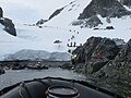
Orne Harbor ( 64°37′S62°32′W / 64.617°S 62.533°W / -64.617; -62.533 ) is a cove one mile wide, indenting the west coast of Graham Land two miles southwest of Cape Anna along the Danco Coast on the west side of the Antarctic Peninsula. Discovered by the Belgian Antarctic Expedition under Gerlache in 1898. The name Orne Harbor was probably in use by Norwegian whalers, because it was used by Scottish geologist David Ferguson following his geologic reconnaissance of this area aboard the whaler Hanka in 1913. [1]

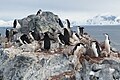
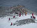
Orne Harbor is a popular excursion site for tourist expeditions to the Antarctic Peninsula. Activities including kayaking in the harbor and visiting a nearby chinstrap penguin colony. [2]

See also

Related Research Articles

<span class="mw-page-title-main">Deception Island</span> Active volcanic island in the South Shetland archipelago

Deception Island is in the South Shetland Islands close to the Antarctic Peninsula with a large and usually "safe" natural harbor, which is occasionally affected by the underlying active volcano. This island is the caldera of an active volcano, which seriously damaged local scientific stations in 1967 and 1969. The island previously held a whaling station. It is now a tourist destination with over 15,000 visitors per year. Two research stations are operated by Argentina and Spain during the summer season. While various countries have asserted sovereignty, it is still administered under the Antarctic Treaty System.

<span class="mw-page-title-main">Antarctic Peninsula</span> Peninsula located in northern Antarctica

The Antarctic Peninsula, known as O'Higgins Land in Chile and Tierra de San Martín in Argentina, and originally as Graham Land in the United Kingdom and the Palmer Peninsula in the United States, is the northernmost part of mainland Antarctica.

The Scaife Mountains is a group of mountains rising west of Prehn Peninsula and between the Ketchum Glacier and Ueda Glacier, at the base of the Antarctic Peninsula.

<span class="mw-page-title-main">Cuverville Island</span> Island of Antarctica

Cuverville Island or Île de Cavelier de Cuverville is a dark, rocky island lying in Errera Channel between Arctowski Peninsula and the northern part of Rongé Island, off the west coast of Graham Land in Antarctica. Cuverville Island was discovered by the Belgian Antarctic Expedition (1897–1899) under Adrien de Gerlache, who named it for Jules de Cuverville (1834–1912), a vice admiral of the French Navy.

<span class="mw-page-title-main">Gerlache Strait</span> Strait in the Palmer Archipelago, Antarctica

Gerlache Strait or de Gerlache Strait or Détroit de la Belgica is a channel/strait separating the Palmer Archipelago from the Antarctic Peninsula. The Belgian Antarctic Expedition, under Lt. Adrien de Gerlache, explored the strait in January and February 1898, naming it for the expedition ship Belgica. The name was later changed to honor the commander himself.

<span class="mw-page-title-main">Brown Station</span> Antarctic base

Brown Station is an Argentine Antarctic base and scientific research station named after Admiral William Brown, the father of the Argentine Navy. It is located on Sanavirón Peninsula along Paradise Harbor, Danco Coast, in Graham Land, Antarctic Peninsula.

<span class="mw-page-title-main">Guest Peninsula</span> Snow-covered peninsula in Marie Byrd Land, Antarctica

The Guest Peninsula is a snow-covered peninsula about 45 nautical miles long between the Sulzberger Ice Shelf and Block Bay, in the northwest part of Marie Byrd Land, Antarctica.

<span class="mw-page-title-main">Cape Royds</span> Landform on Ross Island, Antarctica

Cape Royds is a dark rock cape forming the western extremity of Ross Island, facing on McMurdo Sound, Antarctica. It was discovered by the British National Antarctic Expedition (BrNAE) (1901–1904) and named for Lieutenant Charles Royds, Royal Navy, who acted as meteorologist on the expedition. Royds subsequently rose to become an Admiral and was later Commissioner of the Metropolitan Police, London. The cape is the site of Shackleton's Hut, the expedition camp of the British Antarctic Expedition, 1907–09.

<span class="mw-page-title-main">Useful Island</span>

Useful Island is an island 3.2 km west of Rongé Island, with a string of rocks between, lying in Gerlache Strait off the west coast of Graham Land. It was discovered by the Belgian Antarctic Expedition, 1897–99, under Adrien de Gerlache. The name appears on a chart based upon a 1927 survey by Discovery Investigations personnel on the RRS Discovery.

<span class="mw-page-title-main">Neko Harbour</span> Refuge

Neko Harbour is an inlet of the Antarctic Peninsula on Andvord Bay, situated on the west coast of Graham Land.

<span class="mw-page-title-main">Vidbol Glacier</span> Glacier in Antarctica

Vidbol Glacier is the 5.5 km long and 1.5 km wide glacier on Arctowski Peninsula on Danco Coast in Graham Land on the Antarctic Peninsula draining the north slopes of Pulfrich Peak. Flowing northwestwards west of Henryk Peak and east of Mount Dedo to enter Gerlache Strait at Orne Harbour.

Aphrodite Glacier is a glacier 15 nautical miles (28 km) long flowing north to the east coast of the Antarctic Peninsula 3 nautical miles (6 km) west of Victory Nunatak.

<span class="mw-page-title-main">Ardley Island</span> Island in Antarctica

Ardley Island is an island 1.9 kilometres (1 nmi) long, lying in Maxwell Bay close off the south-west end of King George Island, in the South Shetland Islands of Antarctica. It was charted as a peninsula in 1935 by Discovery Investigations personnel of the Discovery II and named for Lieutenant R.A.B. Ardley, Royal Naval Reserve, an officer on the ship in 1929–31 and 1931–33. Aerial photography has since shown that the feature is an island with Braillard Point being the headland forming the northeast end of Ardley Island. It has been designated an Antarctic Specially Protected Area because of the importance of its seabird colonies.

<span class="mw-page-title-main">Waddington Bay</span> Bay in Graham Land, Antarctica

Waddington Bay is an Antarctic bay 2 nautical miles (3.7 km) long, in a NW-SE direction, and 1 nautical mile (1.9 km) wide, indenting the west coast of Kyiv Peninsula, Graham Land, immediately north of Cape Tuxen. This bay is partially defined on the charts of the Belgian Antarctic Expedition, 1897–99, under Gerlache. It was more fully delineated by the French Antarctic Expedition, 1908–10, under Charcot, who named it for Senator Waddington, president of the Chamber of Commerce at Rouen.

<span class="mw-page-title-main">Watson Peninsula</span> Peninsula of Antarctica

Watson Peninsula is a narrow peninsula 4 km (2.5 mi) long separating Macdougal and Marr Bays on the north coast of Laurie Island, in the South Orkney Islands of Antarctica. It was charted in 1903 by the Scottish National Antarctic Expedition under Bruce, who named it for G.L. Watson, yacht designer and redesigner of the expedition ship Scotia.

<span class="mw-page-title-main">Tupinier Islands</span> Islands of Antarctica

The Tupinier Islands are a group of pyramid-shaped islands lying off the north coast of Trinity Peninsula, about 6 km (3.7 mi) west of Cape Ducorps. They were discovered by the French expedition under Captain Jules Dumont d'Urville, 1837–40, and named after Baron Tupinier (1779–1850), an official of the French Naval Ministry who was instrumental in obtaining government support for the expedition. The islands were recharted by the Falkland Islands Dependencies Survey (FIDS) in 1946.

<span class="mw-page-title-main">Pléneau Island</span> Island in Wilhelm Archipelago, Antarctica

Pléneau Island is an island, 0.8 nautical miles (1.5 km) long, lying just northeast of Hovgaard Island in the Wilhelm Archipelago, Charted as a peninsula of Hovgaard Island by the French Antarctic Expedition, 1903–05, under J.B. Charcot, who named its northeast point for Paul Pléneau, photographer of the expedition. The feature was first shown to be an island on an Argentine government chart in 1957.

<span class="mw-page-title-main">Ferguslie Peninsula</span> Peninsula of Antarctica

Ferguslie Peninsula is a peninsula 2.4 km (1.5 mi) long, lying between Browns Bay and Macdougal Bay on the north coast of Laurie Island, in the South Orkney Islands of Antarctica. The peninsula was charted in 1903 by the Scottish National Antarctic Expedition under William Speirs Bruce, who named it for Ferguslie, the residence of James Coats, chief patron of the expedition.

Stefansson Strait is an ice-filled strait 35 nautical miles long and 3 to 10 nautical miles wide, between the east coast of Palmer Land and Hearst Island, Antarctica.

The Smith Peninsula is an ice-covered, "dog-legged" peninsula 25 nautical miles long and 10 nautical miles wide, extending in an easterly direction between Keller Inlet and Nantucket Inlet from the east coast of Palmer Land, Antarctica.

References