Friday Harbor Airport is a public use airport located just southwest of the town center of Friday Harbor on San Juan Island in the U.S. state of Washington. It is owned by the Port of Friday Harbor. Friday Harbor is also the default airport of Microsoft Flight Simulator X, although Aircraft spawn in the air above the airport and must land there first.
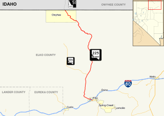
State Route 225 is a state highway in Elko County, Nevada, United States. Known as the Mountain City Highway, it connects the city of Elko to the town of Owyhee near the southwestern Idaho border via Mountain City. The route provides connections to Mountain Home, Idaho and Interstate 84 via Idaho State Highway 51.

Toledo Suburban Airport is a public use airport located two nautical miles (3.7 km) southwest of the central business district of Lambertville, a city in Monroe County, Michigan, United States. It is located just north of Michigan's border with Ohio and northwest of the city of Toledo, Ohio. It is included in the Federal Aviation Administration (FAA) National Plan of Integrated Airport Systems for 2017–2021, in which it is categorized as a general aviation facility.
University Airport is a public-use airport located two nautical miles west of the central business district of Davis, a city in Yolo County, California, United States. It is owned by the University of California and operated by Transportation and Parking Services of the University of California, Davis. Of the ten campuses in the UC system, Davis is the only one with its own airport.

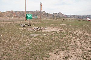
Owyhee Airport is a public use airport located 4 nautical miles west of the central business district of Owyhee, in Elko County, Nevada, United States. It is owned by the Shoshone-Paiute Tribes and is located within the Duck Valley Indian Reservation.

Treasure Coast International Airport is a public airport located three miles (5 km) northwest of the central business district of Fort Pierce, a city in St. Lucie County, Florida, United States. It is owned by the St. Lucie Board of County Commissioners.

Hermiston Municipal Airport is a city-owned, public-use airport located two nautical miles (3.7 km) southeast of the central business district of Hermiston, in Umatilla County, Oregon, United States.
Fernandina Beach Municipal Airport is a city-owned public-use airport located on Amelia Island three nautical miles (6 km) south of the central business district of Fernandina Beach, a city in Nassau County, Florida, United States. It is designated as a reliever airport for Jacksonville International Airport.

Beaver County Airport or is a county-owned public airport three miles northwest of Beaver Falls, in Beaver County, Pennsylvania.

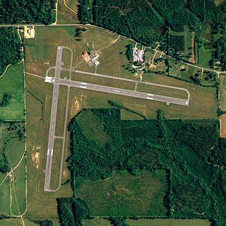
Flagler County Airport is a county-owned public-use airport located three miles (5 km) east of the central business district of Bunnell, a city in Flagler County, Florida, United States. The airport's former FAA location identifiers were X47 and XFL. The airfield was originally constructed by the United States Navy during World War II as Naval Outlying Field Bunnell , an auxiliary airfield for flight training operations originating from nearby Naval Air Station Jacksonville, NAS Daytona Beach and NAS DeLand. Following the end of the war, the airfield was transferred from the Navy to Flagler County for use as a general aviation airport.

Owyhee Reservoir or Owyhee Lake is a reservoir on the Owyhee River in Malheur County, Oregon, United States. Located in far Eastern Oregon near the Idaho border, the reservoir is Oregon's longest at 52 miles (84 km). The 13,900-acre (56 km2) lake is home to several species of fish, including crappie, rainbow trout, largemouth bass, smallmouth bass, yellow perch, and brown bullhead. An artificial lake, it was created in 1932 with the completion of the Owyhee Dam. The lake supplies water for irrigation for 1,800 farms covering 118,000 acres of land in Eastern Oregon and Southwestern Idaho. Seasonal Lake Owyhee State Park is located on the northeast shore and includes a boat ramp.
Middleton Field is a public-use airport located 5 nautical miles west of the central business district of Evergreen, a city in Conecuh County, Alabama, United States. According to the FAA's National Plan of Integrated Airport Systems for 2009–2013, it is categorized as a general aviation facility. Although the airport is owned by the City of Evergreen, it is primarily used for flight training by the U.S. Navy.
Lakehill Airport, is a privately owned airport near Mars, Pennsylvania, U.S., part of the Pittsburgh metropolitan area. It is the smallest of the three airports located in Butler County. The other two are the Butler County Airport, and the Butler Farm Show Airport.

Marianna Municipal Airport is five miles northeast of Marianna, in Jackson County, Florida. The FAA's National Plan of Integrated Airport Systems for 2009–2013 categorized it as a general aviation airport. It was formerly Graham Air Base.

Sylacauga Municipal Airport, also known as Merkel Field, is a city-owned public-use airport located three nautical miles west of the central business district of Sylacauga, a city in Talladega County, Alabama, United States. It is included in the FAA's National Plan of Integrated Airport Systems for 2011–2015, which categorized it as a general aviation facility.
Miami Homestead General Aviation Airport is a county-owned public-use airport in unincorporated Miami-Dade County, Florida, United States, located four nautical miles (7 km) northwest of the central business district of Homestead.

Inverness Airport is a public use airport located two nautical miles (4 km) southeast of the central business district of Inverness, a city in Citrus County, Florida, United States. The airport is owned by Citrus County and contains an aviation unit of the Citrus County Sheriff's Office. It is also located next to the Citrus County Speedway.

Naval Outlying Field Summerdale is a military use airport located in Summerdale, a town in Baldwin County, Alabama, United States. It is under the operational control of NAS Whiting Field and is used for flying training.
Herron Airport, is privately owned airport in New Cumberland, West Virginia, U.S., part of the Pittsburgh Combined Statistical Area. It was opened in November 1946.
Eddie Dew Memorial Airpark, is a privately owned airport near Toronto, Ohio, U.S., part of the Pittsburgh Combined Statistical Area. The airport opened in December 1937. Twenty-two aircraft are reported as being based at the airport; approximately 2,850 aircraft movements per year take place.