
Aleknagik Airport, also known as Aleknagik (New) Airport, is a state-owned, public-use airport located one nautical mile (1.85 km) east of the central business district of Aleknagik, a city in the Dillingham Census Area of the U.S. state of Alaska.
Pinehurst Regional Airport is a public airport located 3 miles (5 km) north of Southern Pines and 5 miles northeast of Pinehurst, in Moore County, North Carolina, USA. The airport covers 500 acres (202 ha) and has one runway. The current runway is paved, 6,502 feet long and 150 feet wide. SOP is primarily used for general aviation.
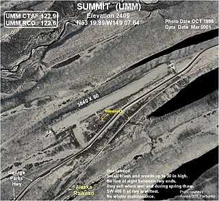
Summit Airport is a state-owned public-use airport located in Summit, in the Matanuska-Susitna Borough of the U.S. state of Alaska. It is about six miles south-southwest of Cantwell, Alaska.
Kalskag Airport is a public airport located one mile (1.6 km) west of the central business district of Upper Kalskag, a city in the Bethel Census Area of the U.S. state of Alaska. The airport is owned by the state. It is situated on the Kuskokwim River, between the cities of Upper Kalskag and Lower Kalskag.

Arlington Municipal Airport is a public airport located one mile (2 km) northeast of the central business district of Arlington, in Gilliam County, Oregon, United States. It is owned by the City of Arlington.

Robert (Bob) Curtis Memorial Airport is a state-owned public-use airport located one nautical mile north of the central business district of Noorvik, a village in the Northwest Arctic Borough of the U.S. state of Alaska.
Ugnu–Kuparuk Airport is a private-use airport located in Kuparuk, Alaska, United States. It is privately owned by ConocoPhillips. which operates the Kuparuk oil field.
Shungnak Airport is a state-owned public-use airport located in Shungnak, a city in the Northwest Arctic of the U.S. state of Alaska.
Wales Airport is a state-owned public-use airport located one nautical mile (2 km) northwest of the central business district of Wales, a city in the Nome Census Area of the U.S. state of Alaska.
Eagle Airport is a state-owned public airport two miles east of Eagle, in the Southeast Fairbanks Census Area of Alaska.
Circle Hot Springs Airport is a state-owned public-use airport serving Circle Hot Springs, in the Yukon-Koyukuk Census Area of the U.S. state of Alaska.

Shageluk Airport is a state-owned public-use airport located one nautical mile (1.85 km) north of the central business district of Shageluk, a city in the Yukon-Koyukuk Census Area of the U.S. state of Alaska.
Red Devil Airport is a public use airport located one nautical mile (1.85 km) northwest of the central business district of Red Devil, in Bethel Census Area of the U.S. state of Alaska.
Point Baker Seaplane Base is a state owned, public use seaplane base located in Point Baker, a community in the Prince of Wales-Hyder Census Area of the U.S. state of Alaska. It is included in the National Plan of Integrated Airport Systems for 2011–2015, which categorized it as a general aviation facility.
Port Protection Seaplane Base is a state owned, public use seaplane base located in Port Protection, a community in the Prince of Wales-Hyder Census Area of the U.S. state of Alaska. It is included in the National Plan of Integrated Airport Systems for 2011–2015, which categorized it as a general aviation facility.
Kokhanok Airport is a state-owned public-use airport located two nautical miles (3.7 km) southwest of the central business district of Kokhanok, in the Lake and Peninsula Borough of the U.S. state of Alaska.

Port Alsworth Airport is a private-use airport serving Port Alsworth which is located in the Lake and Peninsula Borough of the U.S. state of Alaska. As per Federal Aviation Administration records, the airport had 2,634 passenger boardings (enplanements) in calendar year 2019, an increase of 52.87% from the 1,723 enplanements in 2018.
Alsek River Airport is a public-use airport located 44 nautical miles (81 km) southeast of the central business district of Yakutat, a city and borough in the U.S. state of Alaska. It is owned by the USFS Tongass National Forest. As per Federal Aviation Administration records, the airport had 507 passenger boardings (enplanements) in calendar year 2008.
Ugashik Airport is a state-owned public-use airport located one nautical mile (2 km) north of the central business district of Ugashik, in the Lake and Peninsula Borough of the U.S. state of Alaska. It is included in the National Plan of Integrated Airport Systems for 2011–2015, which categorized it as a general aviation airport.
Eddie Dew Memorial Airpark, is a privately owned airport near Toronto, Ohio, U.S., part of the Pittsburgh Combined Statistical Area. The airport opened in December 1937. Twenty-two aircraft are reported as being based at the airport; approximately 2,850 aircraft movements per year take place.