Astoria Regional Airport | |||||||||||||||
|---|---|---|---|---|---|---|---|---|---|---|---|---|---|---|---|
 | |||||||||||||||
| Summary | |||||||||||||||
| Airport type | Public | ||||||||||||||
| Owner | Port of Astoria | ||||||||||||||
| Serves | Astoria, Oregon | ||||||||||||||
| Location | Warrenton, Oregon | ||||||||||||||
| Elevation AMSL | 14 ft / 4 m | ||||||||||||||
| Coordinates | 46°09′29″N123°52′43″W / 46.15806°N 123.87861°W | ||||||||||||||
| Website | PortOfAstoria.com/airport | ||||||||||||||
| Map | |||||||||||||||
 AST Location of airport in Oregon / United States  AST AST (the United States) | |||||||||||||||
 | |||||||||||||||
| Runways | |||||||||||||||
| |||||||||||||||
| Statistics (2019) | |||||||||||||||
| |||||||||||||||
Source: Federal Aviation Administration [1] | |||||||||||||||
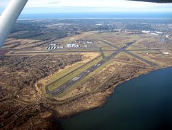
Astoria Regional Airport( IATA : AST, ICAO : KAST, FAA LID : AST) is a joint civil-military public airport in Warrenton, three miles southwest of Astoria, in Clatsop County, Oregon. [1] The airport is owned by the Port of Astoria [1] and is the home of Coast Guard Air Station Astoria.
Contents
The airport has no airline flights. Flights to Portland International Airport were most recently provided by SeaPort Airlines from March 2008 [2] until Spring of 2010. [3] Until 1974-75 Astoria had flights on West Coast Airlines and its successors.
Federal Aviation Administration records say the airport had 1,851 passenger boardings (enplanements) in calendar year 2008, [4] 1,531 in 2009 and 3,482 in 2010. [5] The National Plan of Integrated Airport Systems for 2011–2015 categorized it as a general aviation facility based on enplanements in 2008 (the commercial service category requires 2,500 per year) [6] but it would be categorized as commercial service - non-primary based in enplanements in 2010.