Rome State Airport

Last updated
Rome State Airport
Summary
Airport type Public
Owner Oregon Department of Aviation
Serves Rome, Oregon
Elevation  AMSL 4,053 ft / 1,235 m
Coordinates 42°34′40″N117°53′08″W / 42.57778°N 117.88556°W / 42.57778; -117.88556 Coordinates: 42°34′40″N117°53′08″W / 42.57778°N 117.88556°W / 42.57778; -117.88556
Map
USA Oregon location map.svg
Airplane silhouette.svg
REO
Location of airport in Oregon / United States
Usa edcp relief location map.png
Airplane silhouette.svg
REO
REO (the US)
Runways
Direction Length Surface
ft m
3/21 6,000 1,829 Gravel
Statistics (2009)
Aircraft operations 100

Rome State Airport( IATA : REO, ICAO : KREO, FAA LID : REO) is a public use airport located 20  nautical miles (23  mi, 37  km) southwest of the central business district of Rome, in Malheur County, Oregon, United States. It is owned by the Oregon Department of Aviation. [1]

An IATA airport code, also known as an IATA location identifier, IATA station code or simply a location identifier, is a three-letter code designating many airports around the world, defined by the International Air Transport Association (IATA). The characters prominently displayed on baggage tags attached at airport check-in desks are an example of a way these codes are used.

ICAO airport code four-letter code designating many airports around the world

The ICAOairport code or location indicator is a four-letter code designating aerodromes around the world. These codes, as defined by the International Civil Aviation Organization and published in ICAO Document 7910: Location Indicators, are used by air traffic control and airline operations such as flight planning.

Federal Aviation Administration United States Government agency dedicated to civil aviation matters

The Federal Aviation Administration (FAA) of the United States is a national authority with powers to regulate all aspects of civil aviation. These include the construction and operation of airports, air traffic management, the certification of personnel and aircraft, and the protection of U.S. assets during the launch or re-entry of commercial space vehicles.

Contents

History

The airport was built by the United States Army Air Forces about 1942, and was known as Rome Flight Strip. It was an emergency landing airfield for military aircraft on training flights. It was closed after World War II, and was turned over for local government use by the War Assets Administration (WAA). [2] [3]

United States Army Air Forces Aerial warfare branch of the United States army from 1941 to 1947

The United States Army Air Forces, informally known as the Air Force, was the aerial warfare service of the United States during and immediately after World War II (1939/41–1945), successor to the previous United States Army Air Corps and the direct predecessor of the United States Air Force of today, one of the five uniformed military services. The AAF was a component of the United States Army, which in 1942 was divided functionally by executive order into three autonomous forces: the Army Ground Forces, the Services of Supply, and the Army Air Forces. Each of these forces had a commanding general who reported directly to the Army Chief of Staff.

World War II 1939–1945 global war

World War II, also known as the Second World War, was a global war that lasted from 1939 to 1945. The vast majority of the world's countries—including all the great powers—eventually formed two opposing military alliances: the Allies and the Axis. A state of total war emerged, directly involving more than 100 million people from over 30 countries. The major participants threw their entire economic, industrial, and scientific capabilities behind the war effort, blurring the distinction between civilian and military resources. World War II was the deadliest conflict in human history, marked by 50 to 85 million fatalities, most of whom were civilians in the Soviet Union and China. It included massacres, the genocide of the Holocaust, strategic bombing, premeditated death from starvation and disease, and the only use of nuclear weapons in war.

Facilities and aircraft

Rome State Airport covers an area of 147 acres (59 ha) at an elevation of 4,053 feet (1,235 m) above mean sea level. It has one runway designated 3/21 with a gravel surface measuring 6,000 by 150 feet (1,829 x 46 m). For the 12-month period ending May 13, 2009, the airport had 100 general aviation aircraft operations, an average of 8 per month. [1]

Acre unit of area

The acre is a unit of land area used in the imperial and US customary systems. It is traditionally defined as the area of one chain by one furlong, which is exactly equal to 10 square chains, ​1640 of a square mile, or 43,560 square feet, and approximately 4,047 m2, or about 40% of a hectare. Based upon the International yard and pound agreement of 1959, an acre may be declared as exactly 4,046.8564224 square metres. The acre is a statute measure in the United States and was formerly one in the United Kingdom and almost all countries of the former British Empire, although informal use continues.

Hectare metric unit of area

The hectare is an SI accepted metric system unit of area equal to a square with 100-metre sides, or 10,000 m2, and is primarily used in the measurement of land. There are 100 hectares in one square kilometre. An acre is about 0.405 hectare and one hectare contains about 2.47 acres.

Elevation Height of a geographic location above a fixed reference point

The elevation of a geographic location is its height above or below a fixed reference point, most commonly a reference geoid, a mathematical model of the Earth's sea level as an equipotential gravitational surface . The term elevation is mainly used when referring to points on the Earth's surface, while altitude or geopotential height is used for points above the surface, such as an aircraft in flight or a spacecraft in orbit, and depth is used for points below the surface.

Related Research Articles

Winter Havens Gilbert Airport

Winter Haven's Gilbert Airport is a city-owned, public-use airport located three nautical miles (6 km) northwest of the central business district of Winter Haven, a city in Polk County, Florida, United States. It is owned by the City of Winter Haven. It is also known as Winter Haven Municipal Airport or Gilbert Field. Jack Browns Seaplane Base is located adjacent to the airport, connected by a taxiway.

Ryan Airfield airport

Ryan Airfield, also known as Ryan Field, is a city-owned, public-use airport located 12 miles southwest of the central business district of Tucson, a city in Pima County, Arizona, United States. It is included in the National Plan of Integrated Airport Systems for 2011–2015, which categorized it as a reliever airport. It is mostly used for general aviation but also serves a significant amount of law enforcement and military helicopter activity. Approximately 50% of Ryan's traffic is training-related.

Owyhee Airport

Owyhee Airport is a public use airport located 4 nautical miles west of the central business district of Owyhee, in Elko County, Nevada, United States. It is owned by the Shoshone-Paiute Tribes and is located within the Duck Valley Indian Reservation.

Denton Enterprise Airport

Denton Enterprise Airport, also known as Denton Airport and previously Denton Municipal Airport, is a city-owned, public-use airport located three nautical miles (6 km) west of the central business district of Denton, a city in Denton County, Texas, United States.

Aurora State Airport airport

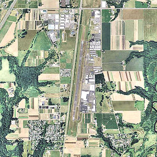
Aurora State Airport is a public airport located one mile (2 km) northwest of the central business district of Aurora, a city in Marion County, Oregon, United States. It is owned by the Oregon Department of Aviation.

Pacific City State Airport

Pacific City State Airport is a public use airport located one nautical mile (2 km) south of the central business district of Pacific City, in Tillamook County, Oregon, United States. It is owned by the Oregon Department of Aviation.

Allen Army Airfield

Allen Army Airfield is a public and military use airport serving Fort Greely and located three miles (5 km) south of the central business district of Delta Junction, a city in the Southeast Fairbanks Census Area of the U.S. state of Alaska. It is owned by the United States Army, which has an agreement with the City of Delta Junction for joint use of the airfield by both military and civilian aircraft.

St. Elmo Airport

St. Elmo Airport is a state-owned public-use airport located two nautical miles west of the central business district of St. Elmo, in Mobile County, Alabama, United States. It is included in the FAA's National Plan of Integrated Airport Systems for 2011–2015, which categorized it as a general aviation facility.

Crisp County–Cordele Airport

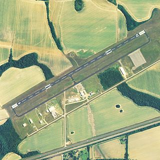
Crisp County–Cordele Airport is a county-owned, public-use airport located two nautical miles (4 km) northeast of the central business district of Cordele, a city in Crisp County, Georgia, United States. It is included in the National Plan of Integrated Airport Systems for 2011–2015, which categorized it as a general aviation facility. The airport does not have scheduled commercial airline service.

Grand Strand Airport

Grand Strand Airport is a county-owned, public-use airport located one nautical mile (1.85 km) northwest of the central business district of North Myrtle Beach, in Horry County, South Carolina, United States. The name Grand Strand refers to a nearby 60-mile stretch of beach.

Fort Sumner Municipal Airport

Fort Sumner Municipal Airport is a village owned, public use airport located two nautical miles (4 km) northeast of the central business district of Fort Sumner, a village in De Baca County, New Mexico, United States. It is included in the National Plan of Integrated Airport Systems for 2011–2015, which categorized it as a general aviation airport.

Mitchell Municipal Airport

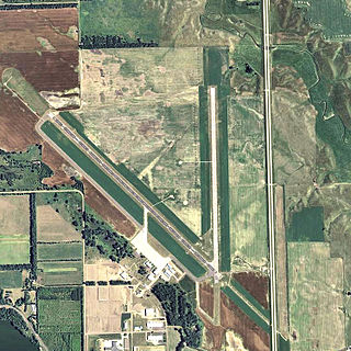
Mitchell Municipal Airport is a city-owned, public-use airport located three nautical miles (6 km) north of the central business district of Mitchell, a city in Davison County, South Dakota, United States. It is included in the National Plan of Integrated Airport Systems for 2011–2015, which categorized it as a general aviation airport.

Carrabelle–Thompson Airport

Carrabelle–Thompson Airport is a public use airport located three nautical miles (6 km) west of the central business district of Carrabelle, a city in Franklin County, Florida, United States. It is owned by the Carrabelle Port and Airport Authority.

Artesia Municipal Airport

Artesia Municipal Airport is a city-owned, public-use airport located three nautical miles (6 km) west of the central business district of Artesia, a city in Eddy County, New Mexico, United States. It is included in the National Plan of Integrated Airport Systems for 2011–2015, which categorized it as a general aviation facility.

Deblois Flight Strip

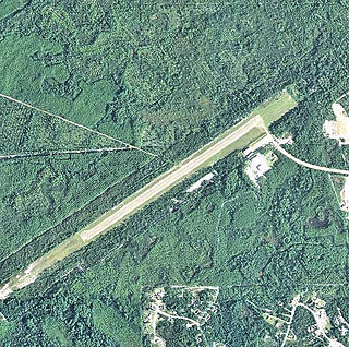
Deblois Flight Strip is a public-use airport located two nautical miles southeast of the central business district of Deblois, a town in Washington County, Maine, United States. It is currently owned by the Maine Department of Transportation, and managed by Randy Gray, Superintendent of Operations for the Eastern Region.

Dell Flight Strip

Dell Flight Strip is a public-use airport located one nautical mile northwest of the central business district of Dell, in Beaverhead County, Montana, United States. It is owned by the Montana Department of Transportation Aeronautics Division and provides general aviation service.

Homerville Airport is a city-owned public-use airport located two nautical miles (3.7 km) northwest of the central business district of Homerville, a city in Clinch County, Georgia, United States.

Bowers Airport public airport just north of Ellensburg, Washington

Bowers Field is a county-owned, public-use airport in Kittitas County, Washington, United States. It is located two nautical miles (4 km) north of the central business district of Ellensburg, Washington. This airport is included in the National Plan of Integrated Airport Systems for 2011–2015, which categorized it as a general aviation facility.

Seward Airport

Seward Airport is a state-owned, public-use airport located two nautical miles northeast of the central business district of Seward, a city in Kenai Peninsula Borough of the U.S. state of Alaska. This airport is included in the FAA's National Plan of Integrated Airport Systems for 2011–2015, which categorized it as a general aviation facility.

Chickasha Municipal Airport

Chickasha Municipal Airport is a city-owned, public-use airport located three nautical miles (6 km) northwest of the central business district of Chickasha, a city in Grady County, Oklahoma, United States. It is included in the National Plan of Integrated Airport Systems for 2011–2015, which categorized it as a general aviation facility.

References

  1. 1 2 3 FAA Airport Master Record for REO ( Form 5010 PDF ). Federal Aviation Administration. Effective May 31, 2012.
  2. PD-icon.svg This article incorporates  public domain material from the Air Force Historical Research Agency website http://www.afhra.af.mil/ .
  3. Shaw, Frederick J. (2004), Locating Air Force Base Sites History’s Legacy, Air Force History and Museums Program, United States Air Force, Washington DC, 2004.
The National Map

The National Map is a collaborative effort of the United States Geological Survey (USGS) and other federal, state, and local agencies to improve and deliver topographic information for the United States. The purpose of the effort is to provide "...a seamless, continuously maintained set of public domain geographic base information that will serve as a foundation for integrating, sharing, and using other data easily and consistently".