Albany Municipal Airport is a general aviation airport located 3 nautical miles (6 km) east of the city of Albany in Linn County, Oregon, United States. It is publicly owned and operated by the City of Albany. It is the oldest known operating airfield in Oregon, opening in 1920. There are 58 aircraft based at the municipal airport; 49 Single engine airplanes, 7 multi engine, and 2 jet airplanes. On average there are 62 aircraft operations per day.

McNary Field is in Marion County, Oregon, two miles southeast of downtown Salem, which owns it. The airport is named for U.S. Senator Charles L. McNary.

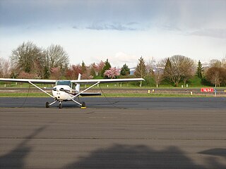
Independence State Airport is a public-use airport located one mile (1.6 km) northwest of the central business district of Independence, a city in Polk County, Oregon, United States. It is owned by the Oregon Department of Aviation.

Astoria Regional Airport is a public airport in Warrenton, three miles southwest of Astoria, in Clatsop County, Oregon. The airport is owned by the Port of Astoria and is the home of Coast Guard Air Station Astoria.

Joseph State Airport is a public use airport located one nautical mile west of the central business district of Joseph, a city in Wallowa County, Oregon, United States. It is owned by the Oregon Department of Aviation.
Lake County Airport is a public airport three miles (5 km) southwest of Lakeview, in Lake County, Oregon.

Sportsman Airpark, is a public airport located one mile southeast of Newberg in Yamhill County, Oregon, USA.

Seaside Municipal Airport, is a General aviation airport located one mile (1.6 km) Northeast of Seaside in Clatsop County, Oregon, USA. It is owned and operated as a municipal airport by the city of Seaside. It is the closest airport to Seaside, Gearhart, and Cannon Beach. The airport has one asphalt runway, a parallel taxiway, a parking apron with space for up to 20 aircraft, and a 5-bay hangar building.

Arlington Municipal Airport is a public airport located one mile (2 km) northeast of the central business district of Arlington, in Gilliam County, Oregon, United States. It is owned by the City of Arlington.
Toketee State Airport, is a public airport located two miles south of Clearwater in Douglas County, Oregon, USA. It is closed between November 1st and May 1st, and pilots are advised that elk and deer can sometimes be found on the runway.

Valley View Airport, is a privately owned, public use airport located 1 mile (1.6 km) northeast of Estacada in Clackamas County, Oregon, United States.
Crescent Lake State Airport, is a public airport located two miles (3.2 km) north of Crescent Lake in Klamath County, Oregon, USA. On-airport camping is allowed, and boat rentals are available nearby. The airport is closed November 1 through May 1 due to snow.

Cape Blanco State Airport, is a public airport located four miles southwest of Denmark in Curry County, Oregon, USA. The airport was constructed during World War II between 1944 & 1945 and was originally leased to the US Navy. Previous owners include Curry County and the Oregon State Highway Department.

Davis Airport is a privately owned, public use airport in Linn County, Oregon, United States. It is located one nautical mile (2 km) south of the central business district of Gates, Oregon, a city in Marion County and Linn County.

Oakridge State Airport, is a public airport located 1 mile (1.6 km) west of Oakridge, in Lane County, Oregon, USA. It has one 3,610 ft long runway.
Pacific City State Airport is a public use airport located one nautical mile (2 km) south of the central business district of Pacific City, in Tillamook County, Oregon, United States. It is owned by the Oregon Department of Aviation.
Powers Airport, is a public airport located 1 mile (1.6 km) southwest of Powers, in Coos County, Oregon, USA.
George Felt Airport, is a public airport located three miles west of Roseburg in Douglas County, Oregon, USA.

Toledo State Airport, is a public airport located one mile southwest of Toledo in Lincoln County, Oregon, USA.
Whippet Field Airport is a private airport located 6 miles northeast of Sisters in Deschutes County, Oregon, USA.


