Related Research Articles

Sweet Home is a city in Linn County, Oregon, United States, with a population of 9,828 at the 2020 census. Sweet Home is referred to as the 'Gateway to the Santiam Playground' due to its proximity to nearby lakes, rivers and the Cascade Mountains.

Detroit Lake is a reservoir impounded by the Detroit Dam on the North Santiam River 46 miles (74 km) southeast of Salem, Oregon, United States. The lake is adjacent to Oregon Route 22 near the city of Detroit. This mesotrophic lake stores water for use by the city of Salem and other nearby communities.

Oregon OR 126 (OR 126) is a 204.63-mile-long (329.32 km) state highway that connects coastal, western, and central parts of the U.S. state of Oregon. A short freeway section of OR 126 in Eugene and Springfield is concurrent with Interstate 105 (I-105).
Santiam Pass is a 4,817-foot (1,468 m) mountain pass in the Cascade Range in central Oregon in the United States. It is located on the border between Linn and Jefferson counties, about 18 mi (29 km) northwest of Sisters, between the prominent volcanic horns of Three Fingered Jack to the north and Mount Washington to the south. Several other smaller volcanoes, including cinder cones and tuyas, are found near the summit of the pass. U.S. Route 20 connects eastern Oregon with the valley of the Santiam River on the west via Santiam Pass. One of the 19 or 20 lakes by the name of Lost Lake is located beside the highway just west of Santiam Pass. The pass may be approached from the west by three distinct routes:

Oregon Route 99E Business is a business route through Salem, Oregon for Oregon Route 99E, which bypasses downtown via Interstate 5 (I-5). A portion of this highway was originally planned to be a freeway, signed as Interstate 305; however the proposed freeway was cancelled after community opposition.

Oregon Route 18 is a state highway that runs between the Oregon Coast, near Lincoln City, and Newberg. OR 18 traverses the Salmon River Highway No. 39 of the Oregon state highway system, named after the river alongside its westernmost segments.

Oregon Route 22 is an Oregon state highway that runs between the Oregon Coast community of Hebo, to a junction with U.S. Route 20 near Santiam Pass in the Cascade Mountains. OR 22 traverses several highways of the Oregon state highway system, including the Three Rivers Highway No. 32, part of the Salmon River Highway No. 39, the Willamina–Salem Highway No. 30, part of the Salem Highway No. 72, and the North Santiam Highway No. 162.

Oregon Route 242, known as a portion of the McKenzie Highway, is an Oregon state highway that runs from Belknap Springs, Oregon through McKenzie Pass in the Oregon Cascades, to Sisters, Oregon, in the United States. The McKenzie Highway was added to the National Register of Historic Places in February, 2011.

Oregon Route 226 is an Oregon state highway that runs between a point east of Albany in the Willamette Valley, and the town of Mehama along the Santiam River. The highway is also known as the Albany–Lyons Highway No. 211, and is 25 miles (40 km) long. It lies mostly within Linn County, except for the very northernmost segment in Mehama, which is in Marion County.

The Oregon Department of Aviation (ODAV) is an agency of the government of the U.S. state of Oregon chiefly responsible for matters relating to the continuing development of aviation as part of the state's transportation system, and the safety of its airways. In addition to operating the 28 airports owned by the State of Oregon, the department licenses more than 450 public or private airports, heliports and landing areas, and registers all pilots and non-military aircraft based within the state. Its activities include overseeing aviation system planning, providing administrative and technical support for community airport planning and development, administering an airport pavement maintenance program, providing small community aviation grants, and conducting aviation and public education programs.
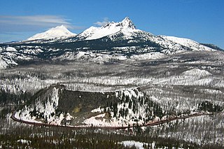
Hogg Rock is a tuya volcano and lava dome in the Cascade Range of northern Oregon, United States, located close to Santiam Pass. Produced by magma with an intermediate andesite composition, it has steep slopes and thick glassy margins. Hogg Rock exhibits normal magnetic polarity and is probably about 80,000 years old.
Alkali Lake State Airport, is a public airport located 8 miles (13 km) northeast of Alkali Lake in Lake County, Oregon, United States.

Santiam State Forest is one of six state forests managed by the Oregon Department of Forestry. The forest is located approximately 25 miles (40 km) southeast of Salem, Oregon, and includes 47,871 acres (193.73 km2) on the western slope of the Cascade Mountains in three Oregon counties: Clackamas, Linn, and Marion. It is bounded on the east by the Willamette National Forest and Mount Hood National Forest. Silver Falls State Park is located west of the forest. The rest of the land surrounding the forest belongs to the Bureau of Land Management or is privately owned. The forest is managed as part of the Department of Forestry's North Cascade District.

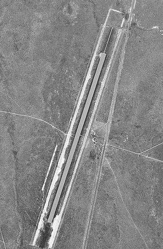
Santiam Junction is a highway junction and unincorporated community in Linn County, Oregon, United States, at the intersection of U.S. Route 20/Oregon Route 126 and Oregon Route 22.
Valley Junction is an unincorporated community in Polk County, Oregon, United States. It is located at the junction of Oregon Route 18 and Oregon Route 22, on the South Yamhill River east of Grand Ronde. A now-abandoned section of the Willamina and Grand Ronde Railway short line passed through Valley Junction. The Fort Yamhill State Heritage Area and Spirit Mountain Casino are nearby.
North Santiam State Recreation Area is a state park in the U.S. state of Oregon, administered by the Oregon Parks and Recreation Department.

U.S. Route 20 (US 20) is a major west–east cross-state highway in the northern part of the U.S. state of Oregon, especially east of the Cascade Mountains. It connects U.S. Route 101 in Newport on the central Oregon Coast to the Idaho state line east of Nyssa.

Austin Junction is an unincorporated community in Grant County, Oregon, United States. It is at the intersection of U.S. Route 26 and Oregon Route 7, about 2.5 miles south of Austin in the Wallowa–Whitman National Forest. The Austin House, a combination café, grocery store, gas station and tavern at this location is named after an early business in nearby Austin. The business is located on Forest Service land and operates with a special-use permit. Austin Junction has a Bates, Oregon mailing address. The elevation is 4,236 feet.

Ames Creek is a small tributary of the South Santiam River in the U.S. state of Oregon. It begins near Chimney Rock in the foothills of the Cascade Range in Linn County. It flows northwest to meet the river at Sweet Home, about 33 miles (53 km) by river from the South Santiam's confluence with the Santiam River. Ames Creek passes under U.S. Route 20 just before entering the river.
John Arthur Ackroyd was an American murderer and suspected serial killer. In 1992, he was sentenced to five life terms in prison for the abduction and murder of Kaye Turner.
References
- ↑ "Santiam Junction". Department of Aviation State Warning Airports. Oregon Department of Transportation. Archived from the original on 18 March 2012. Retrieved 2008-03-17.
- ↑ "SANTIAM JUNCTION STATE AIRPORT OVERVIEW" (PDF). oregon.gov. Retrieved 27 February 2024.