
Aleknagik Airport, also known as Aleknagik (New) Airport, is a state-owned, public-use airport located one nautical mile (1.85 km) east of the central business district of Aleknagik, a city in the Dillingham Census Area of the U.S. state of Alaska.
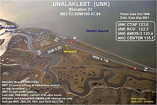
Unalakleet Airport is a state-owned public-use airport located one nautical mile (2 km) north of the central business district of Unalakleet, a city in the Nome Census Area of the U.S. state of Alaska.

Valley View Airport is a privately owned, public use airport located 1 mile (1.6 km) northeast of Estacada in Clackamas County, Oregon, United States.
Crescent Lake State Airport is a public airport located two miles (3.2 km) north of Crescent Lake in Klamath County, Oregon, United States. On-airport camping is allowed, and boat rentals are available nearby. The airport is closed from November 1 through May 1 due to snow.

Oakridge State Airport is a public airport located 1 mile (1.6 km) west of Oakridge, in Lane County, Oregon, United States.

Toledo State Airport is a public airport located one mile (1.6 km) southwest of Toledo in Lincoln County, Oregon, United States.

Ugnu–Kuparuk Airport is a private-use airport located in Kuparuk, Alaska, United States. It is privately owned by ConocoPhillips. which operates the Kuparuk oil field.
Beaver Airport is a state-owned, public-use airport located in the village of Beaver in the Yukon-Koyukuk Census Area of the U.S. state of Alaska.
Shungnak Airport is a state-owned public-use airport located in Shungnak, a city in the Northwest Arctic of the U.S. state of Alaska.
St. Michael Airport is a state-owned, public-use airport located two nautical miles (4 km) west of the central business district of St. Michael, a city in the Nome Census Area of the U.S. state of Alaska.
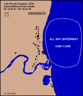
Lake Brooks Seaplane Base is a public-use seaplane base located near Brooks Camp in Katmai National Park, in the Lake and Peninsula Borough of the U.S. state of Alaska. It is owned by the U.S. Department of the Interior.
Prospect Creek Airport is a state-owned public-use airport located three nautical miles (5.5 km) northeast of Prospect Creek, in the Yukon-Koyukuk Census Area of the U.S. state of Alaska.

Arctic Village Airport is a public use airport located one nautical mile (1.8 km) southwest of the central business district of Arctic Village, a Native American village in the Yukon-Koyukuk Census Area of the U.S. state of Alaska. It is owned by the Venetie Tribal Government.

Shageluk Airport is a state-owned public-use airport located one nautical mile (1.85 km) north of the central business district of Shageluk, a city in the Yukon-Koyukuk Census Area of the U.S. state of Alaska.
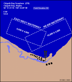
Chignik Bay Seaplane Base is a public-use seaplane base serving Chignik, a city in the Lake and Peninsula Borough of the U.S. state of Alaska.
Nondalton Airport is a state-owned public-use airport located one nautical mile (1.85 km) northwest of the central business district of Nondalton, in the Lake and Peninsula Borough of the U.S. state of Alaska.
Yankee Creek Airport, also known as Yankee Creek 2 Airport, is a privately owned public-use airport located one nautical mile south of the central business district of Yankee Creek, in the Yukon-Koyukuk Census Area of the U.S. state of Alaska.
Herron Airport, is privately owned airport in New Cumberland, West Virginia, U.S., part of the Pittsburgh Combined Statistical Area. It was opened in November 1946, founded by Earle Herron.
Eddie Dew Memorial Airpark, is a privately owned airport near Toronto, Ohio, U.S., part of the Pittsburgh Combined Statistical Area. The airport opened in December 1937. Twenty-two aircraft are reported as being based at the airport; approximately 2,850 aircraft movements per year take place.
Telida Airport is a public use airport located in Telida, in the Yukon-Koyukuk Census Area of the U.S. state of Alaska.
This page is based on this
Wikipedia article Text is available under the
CC BY-SA 4.0 license; additional terms may apply.
Images, videos and audio are available under their respective licenses.