The San Joaquins is a passenger train service operated by Amtrak in California's San Joaquin Valley. Seven daily round trips run between its southern terminus at Bakersfield and Stockton, where the route splits to Oakland or Sacramento.

State Route 152 is a state highway that runs from east to west near the middle of the U.S. state of California from State Route 1 in Watsonville to State Route 99 southeast of Merced. Its western portion provides access to and from Interstate 5 toward Southern California for motorists in or near Gilroy, San Jose, and the rest of the Silicon Valley.

The Altamont Corridor Express is a commuter rail service in California, connecting Stockton and San Jose during peak hours only. ACE is named for the Altamont Pass, through which it runs. Service is managed by the San Joaquin Regional Rail Commission, and operations are contracted to Herzog Transit Services, using AAR assigned reporting mark ACEX. The 86-mile (138 km) route includes ten stops, with travel time about 2 hours and 12 minutes end-to-end. The tracks are owned by Union Pacific Railroad, previously built along the Western Pacific Railroad main line. ACE uses Bombardier BiLevel Coaches and MPI F40PH-3C locomotives.

Pacheco Pass, elevation 1,368 ft (417 m), is a low mountain pass located in the Diablo Range in southeastern Santa Clara County, California. It is the main route through the hills separating the Santa Clara Valley and the Central Valley.

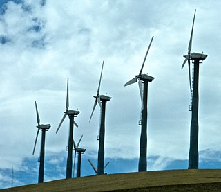
Altamont Pass, formerly Livermore Pass, is a low mountain pass in the Diablo Range of Northern California between Livermore in the Livermore Valley and Tracy in the San Joaquin Valley. The name is actually applied to two distinct but nearby crossings of the range. The lower of the two, at an elevation of 741 ft (226 m), carries two railroad rights-of-way (ROWs) and Altamont Pass Road, part of the old Lincoln Highway and the original alignment of US 50 before it was bypassed c. 1937. The bypass route travels over the higher summit, at 1,009 ft (308 m), and now carries Interstate 580, a major regional highway heavily congested by Central Valley suburbanization.

California High-Speed Rail is a publicly funded high-speed rail system under construction in the U.S. state of California. It is projected to connect the Anaheim Regional Transportation Intermodal Center in Anaheim and Union Station in Downtown Los Angeles with the Salesforce Transit Center in San Francisco via the Central Valley, providing a one-seat ride between Union Station and San Francisco in 2 hours and 40 minutes, a distance of 380 miles (612 km). Future extensions are planned to connect to stations in San Diego County via the Inland Empire, as well as to Sacramento.

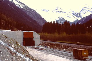
The Mount Macdonald Tunnel, located in the vicinity of Rogers Pass in the Selkirk Mountains of British Columbia, Canada, is a railway tunnel constructed through Mount Macdonald by the Canadian Pacific Railway (CPR).

The Diablo Range is a mountain range in the California Coast Ranges subdivision of the Pacific Coast Ranges. It is located in the eastern San Francisco Bay area south to the Salinas Valley area of northern California, the United States.

The establishment of America's transcontinental rail lines securely linked California to the rest of the country, and the far-reaching transportation systems that grew out of them during the century that followed contributed to the state's social, political, and economic development. When California was admitted as a state to the United States in 1850, and for nearly two decades thereafter, it was in many ways isolated, an outpost on the Pacific, until the First Transcontinental Railroad was completed in 1869.

Throughout the history of Bay Area Rapid Transit, better known as BART, there have been plans to extend service to other areas.

The San Jose–San Francisco–Oakland, CA Combined Statistical Area is a 14-county Combined Statistical Area (CSA) designated by the United States Office of Management and Budget in Northern California that includes the San Francisco Bay Area. The CSA is more extensive than the popular local definition of the Bay Area, which consists of only the nine counties bordering San Francisco and San Pablo Bays: Alameda, Contra Costa, Marin, Napa, San Francisco, San Mateo, Santa Clara, Solano, and Sonoma. This group of counties also elects boards for regional planning and air quality control regulation. The CSA includes Merced, San Joaquin, Santa Cruz, San Benito, and Stanislaus counties, which do not directly border the San Francisco or San Pablo bays, but are economically connected to the other nine counties that do. Merced and Stanislaus Counties were added to the CSA in September 2018.
The California State Transportation Agency (CalSTA) is a state cabinet-level agency responsible for transportation-related departments within the state. The agency was created under Governor Jerry Brown in 2013 after the previous Business, Transportation and Housing Agency's portfolio underwent reorganization.

The California High-Speed Rail Authority was established in 1996 after decades of advocacy for building a high speed rail system in California. The passage of Proposition 1A in 2008, followed by the awarding of federal stimulus funds in 2010, established the initial funding for the California High-Speed Rail system. Construction contracts began to be awarded in 2013, and the groundbreaking ceremony for initial construction was held on January 6, 2015.

Bakersfield is a proposed California High-Speed Rail station in Bakersfield, California. The station is part of the Initial Construction Segment.

Merced station is a proposed California High-Speed Rail station in Merced, California, located in Downtown Merced on Martin Luther King Jr. Way near the interchange with Route 99/59, and is about 7 blocks south from the existing Merced Amtrak station. The station was initially intended to be the northern terminus of the system's Initial Construction Segment. The high-speed rail line runs along the right-of-way of the Union Pacific Railroad at this location.

The California High-Speed Rail system will be built in two phases. Phase 1 will be about 520 miles (840 km) long, and is planned to be completed in 2033, connecting the downtowns of San Francisco, Los Angeles using high-speed rail through the Central Valley with feeder lines served at Merced and an extension to Anaheim. In Phase 2, the route will be extended in the Central Valley north to Sacramento, and from east through the Inland Empire and then south to San Diego. The total system length will be about 800 miles (1,300 km) long. Phase 2 has timeline for completion.
The Caltrain Modernization Program (CalMod) is a $1.9 billion project that will add a positive train control (PTC) system and electrify the main line of the U.S. commuter railroad Caltrain, which serves cities in the San Francisco Peninsula and Silicon Valley, as well as transition from its current diesel-electric locomotive powered trains to electric multiple units (EMU). According to Caltrain, electrification of the tracks will allow it to improve service times via faster acceleration and shorter headways, reduce air pollution and noise, and facilitate a future railway tunnel into downtown San Francisco's Transbay Transit Center.
The Downtown Rail Extension (DTX) is a planned second phase of the San Francisco Transbay Transit Center (TTC). When complete, it will extend the Caltrain Peninsula Corridor commuter rail line from its current northern terminus at 4th and King via a 1.3 mi (2.1 km) tunnel. The new terminus will be close to the Financial District and will provide intermodal connections to BART, Muni, Transbay AC Transit buses, and long-distance buses. In addition, the California High Speed Rail Authority (CHSRA) plans to use DTX and the Caltrain-owned Peninsula Corridor for service on the CHSRA San Francisco–San Jose segment. Because DTX uses a long tunnel, current diesel locomotives are not suitable and the Caltrain Modernization Project (CalMod), which includes electrification of the line and acquisition of electrified rolling stock, is a prerequisite.
The Tri-Valley-San Joaquin Valley Regional Rail Authority is a special-purpose district body formed for the sole purpose of providing a public transit connection between the Bay Area Rapid Transit and Altamont Corridor Express services.
North Lathrop is a future Altamont Corridor Express station in Lathrop, California – the second to be constructed in the city. Whereas the original Lathrop/Manteca station was sited as a compromise to draw commuters from both cities, this station is located closer to residential areas. North Lathrop is designed as a transfer station to allow passengers from San Joaquin Valley shuttle trains to transfer to services bound for San Jose. It is expected to open to revenue service in 2023 as part of the first phase of ACE's expansion to Merced. The station is also planned to serve as the first phase northern terminus of Valley Link, a project by the Tri-Valley-San Joaquin Valley Regional Rail Authority to build a rail connection to Bay Area Rapid Transit's Dublin/Pleasanton station.


