
Austria-Hungary, often referred to as the Austro-Hungarian Empire or the Dual Monarchy, was a multi-national constitutional monarchy in Central Europe between 1867 and 1918. Austria-Hungary was a military and diplomatic alliance of two sovereign states with a single monarch who was titled both emperor of Austria and King of Hungary. Austria-Hungary constituted the last phase in the constitutional evolution of the Habsburg monarchy: it was formed with the Austro-Hungarian Compromise of 1867 in the aftermath of the Austro-Prussian War and was dissolved shortly after Hungary terminated the union with Austria on 31 October 1918.

The Tisza, Tysa or Tisa, is one of the major rivers of Central and Eastern Europe. It was once called "the most Hungarian river" because it flowed entirely within the Kingdom of Hungary. Today, it crosses several national borders.
Novi Sad is the second largest city in Serbia after the capital Belgrade and the capital of the autonomous province of Vojvodina. It is located in the southern portion of the Pannonian Plain on the border of the Bačka and Syrmia geographical regions. Lying on the banks of the Danube river, the city faces the northern slopes of Fruška Gora.

Vojvodina, officially the Autonomous Province of Vojvodina, is an autonomous province that occupies the northernmost part of Serbia, located in Central Europe. It lies within the Pannonian Basin, bordered to the south by the national capital Belgrade and the Sava and Danube Rivers. The administrative center, Novi Sad, is the second-largest city in Serbia.

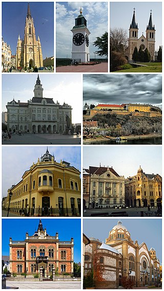
Subotica is a city and the administrative center of the North Bačka District in the autonomous province of Vojvodina, Serbia. Formerly the largest city of Vojvodina region, contemporary Subotica is now the second largest city in the province, following the city of Novi Sad. According to the 2022 census, the city itself has a population of 94,228, and the population of metro area stands at 123,952 people.

Bečej is a town and municipality located in the South Bačka District of the autonomous province of Vojvodina, Serbia. The town has a population of 23,895, while the municipality has 37,351 inhabitants. It is a multiethnic town, predominantly inhabited by Serbs and Hungarians.
Senta is a town and municipality located in the North Banat District of the autonomous province of Vojvodina, Serbia. It is situated on the bank of the Tisa river in the geographical region of Bačka. The town has a population of 18,704, whilst the Senta municipality has 23,316 inhabitants.

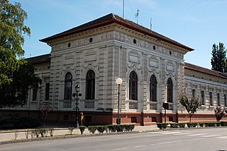
Sombor is a city and the administrative center of the West Bačka District in the autonomous province of Vojvodina, Serbia. The city has a total population of 41,814, while its administrative area has 70,818 inhabitants.
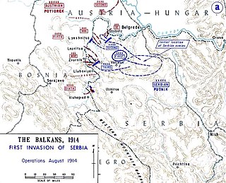
The Battle of Cer was a military campaign fought between Austria-Hungary and Serbia in August 1914, starting three weeks into the Serbian Campaign of 1914, the initial military action of the First World War. It took place around Cer Mountain and several surrounding villages, as well as the town of Šabac. The Battle of Cer is known as the first Allied victory over the Central Powers in the First World War.

The Pannonian Basin, or Carpathian Basin, is a large sedimentary basin situated in southeast Central Europe. The geomorphological term Pannonian Plain is more widely used for roughly the same region though with a somewhat different sense, with only the lowlands, the plain that remained when the Pliocene Epoch Pannonian Sea dried out.

Čoka is a town and municipality located in the North Banat District of the autonomous province of Vojvodina, Serbia. The town has a population of 3,119 and the municipality has 8,556 inhabitants.
Novi Kneževac is a town and municipality located in the North Banat District of the autonomous province of Vojvodina, Serbia. The town has a population of 6,960, while the Novi Kneževac municipality has 11,269 inhabitants according to.

Bačka Topola is a town and municipality located in the North Bačka District of the autonomous province of Vojvodina, Serbia. The municipality is composed of 23 local communities and has a population of 33,321, while the town itself has 14,573 inhabitants.
Srbobran is a town and municipality located in the South Bačka District of the autonomous province of Vojvodina, Serbia. The town is located on the north bank of the Danube-Tisa-Danube canal. The town has a population of 12,009, and the municipality of 16,317.

The July Crisis was a series of interrelated diplomatic and military escalations among the major powers of Europe in the summer of 1914, which led to the outbreak of World War I. The crisis began on 28 June 1914, when Gavrilo Princip, a Bosnian Serb nationalist, assassinated Archduke Franz Ferdinand, heir presumptive to the Austro-Hungarian throne, and his wife Sophie, Duchess of Hohenberg. A complex web of alliances, coupled with the miscalculations of numerous political and military leaders, resulted in an outbreak of hostilities amongst most of the major European nations by early August 1914.

Kovin is a town and municipality located in the South Banat District of the autonomous province of Vojvodina, Serbia. The town has a population of 13,515, while the municipality has 33,722 inhabitants.

Hungarians in Serbia are a recognized national minority in Serbia. According to the 2022 census, the population of ethnic Hungarians in Serbia is 184,442, constituting 2.8% of the total population, which makes them the second-largest ethnic group in the country behind Serbs and the largest minority group. The vast majority of them live in the northern autonomous province of Vojvodina, where they number 182,321 and make up 10.5% of the province's population. Almost 99% of all Hungarians in Serbia live in the province of Vojvodina. Most Hungarians in Serbia are Roman Catholics, while smaller numbers of them are Protestant. Their cultural center is located in Subotica.

The Aranca or Zlatica is a 117 km long river in the Banat region of Romania and Serbia, left tributary of the river Tisa.

Relations between Hungary and Serbia, or Serbo-Hungarian relations form a part of the wider politics of Central and Southeast Europe. The two countries have a long relationship stretching back to the Middle Ages. History of official diplomatic relations of Hungary and Serbia dates back to 21 November 1882, when they were established between the Kingdom of Serbia and Austria-Hungary. Today, Hungary has an embassy in Belgrade and a general consulate in Subotica, while Serbia has an embassy in Budapest and an honorary consulate in Szeged.

Kanjiža formerly Stara Kanjiža is a town and municipality located in the North Banat District of the autonomous province of Vojvodina, Serbia. Kanjiža town has a population of 9,871, while the Kanjiža municipality has 25,343 inhabitants.


