
Vojvodina, officially the Autonomous Province of Vojvodina, is an autonomous province that occupies the northernmost part of Serbia, located in Central Europe. It lies within the Pannonian Basin, bordered to the south by the national capital Belgrade and the Sava and Danube Rivers. The administrative centre, Novi Sad, is the second-largest city in Serbia.

Ruma is a town and municipality in the Srem District of the Autonomous Province of Vojvodina, Serbia. As of 2011, the town has a population of 30,076, while the municipality has a population of 54,339.
Srpska Crnja is a village in Serbia, situated in central-east Banat alongside the border with Romania. It is located in Nova Crnja municipality, Central Banat District, Province of Vojvodina. It is about 120 km away from the capital city of Belgrade, 113 km from Novi Sad, 9 km south-east of Kikinda and 6 km south-west of Jimbolia, Romania. The village has a population of 3753 people and most of its inhabitants are ethnic Serbs (83.77%).
Vojvodina's demographic history reflects its rich history and its former location at the border of the Ottoman and Habsburg empires and at the confluence of various peoples, making it a hotbed of invasion, colonization, and assimilation processes. Currently there are more than 25 ethnic groups living in Vojvodina and six official languages.

Vrbas is a town and municipality located in the South Bačka District of the autonomous province of Vojvodina, Serbia. As of 2022, the town has a population of 20,892, while the municipality has 36,601 inhabitants.

Kula is a town and municipality located in the West Bačka District of the autonomous province of Vojvodina, Serbia. The town has a population of 22,105, while the municipality has a population of 35,592.

Opovo is a town and municipality located in the South Banat District of the autonomous province of Vojvodina, Serbia. The town has a population of 4,546, while Opovo municipality has 10,475 inhabitants.

Tovariševo is a village in Serbia, in the Autonomous Province of Vojvodina. The village has a Serb ethnic majority and its population numbering 2,321 people.
Vojvodina is an autonomous province located in northern Serbia. It consists of the Pannonian Plain in the south, and the Danube and Sava rivers in the north.

Bački Jarak is a town located in the Temerin municipality, in the South Bačka District of Serbia. It is situated in the Autonomous Province of Vojvodina. The town has a Serb ethnic majority and its population numbering 5,687 people.

Jaša Tomić is a town located in the municipality of Sečanj, in the Central Banat District of Serbia. It is situated in the Autonomous Province of Vojvodina. The town has a Serb ethnic majority and a population numbering 2,982 people.

Knićanin is a village in Serbia. It is located in the Zrenjanin municipal area, in the Banat region, Vojvodina province. Its population is 2,034 and most of its inhabitants are ethnic Serbs (97.39%).

Hungarians in Serbia are a recognized national minority in Serbia. According to the 2022 census, the population of ethnic Hungarians in Serbia is 184,442, constituting 2.8% of the total population, which makes them the second-largest ethnic group in the country behind Serbs and the largest minority group. The vast majority of them live in the northern autonomous province of Vojvodina, where they number 182,321 and make up 10.5% of the province's population. Almost 99% of all Hungarians in Serbia live in the province of Vojvodina. Most Hungarians in Serbia are Roman Catholics, while smaller numbers of them are Protestant. Their cultural center is located in Subotica.

Veliki Gaj is a village located in the Plandište municipality, in the South Banat District of Serbia. It is situated in the Autonomous Province of Vojvodina. According to the 2002 census, the population of the village was 790 people, of whom 670 were ethnic Serbs (84.81%).
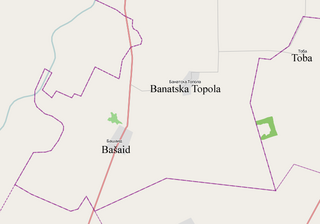
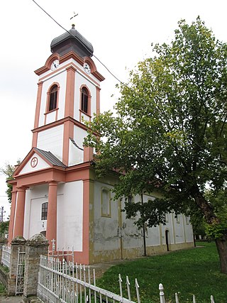
Banatska Topola is a village in the Kikinda municipality, in the North Banat District of the Republic of Serbia. It is situated in the Autonomous Province of Vojvodina. The village has a population of 1,066 of which 570 (53.47%) are ethnic Serbs and 434 (40.71%) are ethnic Hungarians.

Klek is a village located in the Zrenjanin municipality, Central Banat District, Vojvodina, Serbia. The village has a Serb ethnic majority (90.80%), and its population is 3,011.

Stari Lec is a village in Serbia. It is situated in the Plandište municipality, in the South Banat District, Vojvodina province. One of Stari Lec's best known landmarks is Kapetanovo Castle.

Gakovo is a village in Serbia. It is situated in the Sombor municipality, in the West Bačka District, Vojvodina province. The village has a Serb ethnic majority and its population is 2,201.

Kljajićevo is a village in Serbia. It is situated in the Sombor municipality, in the West Bačka District, Vojvodina province. The village has a Serb ethnic majority and its population numbered 6,012 people.

Banatski Despotovac is a village in Serbia. It is located in the municipal area of the City of Zrenjanin, in the Central Banat District, Vojvodina province. The village has a Serb ethnic majority (98.2%) and its population numbers 1,620 people.


