The region Palayamkottai in Tamil is a portmanteau of 'palayam', which refers to a settlement, and 'kottai', which translates to a fort. Historically, Palayamkottai served as the locale of an ancient fort that was employed for the administration of neighbouring districts. Today, the fort lies in ruins and is almost camouflaged by its surrounding old residential edifices. While the classical Tamil pronunciation of the neighbourhood's name is the aforementioned Palayamkottai, the vernacular pronunciation of the settlement is more akin to Palayankottai or Palayankotta, with the latter being more widely preferred by the locals.
Prior to 1994, Tirunelveli and Palayamkottai were formerly administered as two independent municipalities. Tirunelveli and Palayamkottai along with surrounding areas were subsequently merged and established Tirunelveli City, now administered by the Tirunelveli Municipal Corporation.
Palayamkottai is situated on the eastern bank of the perennial Thamirabarani river. The region is very fertile and supports a thriving agrarian community in the midst of many urbanised areas. Regular monsoon rains coupled with the Thamirabarani water sustain the primarily agrarian villages around the city. Palayamkottai is located on the National Highway in close proximity to many bigger cities (international seaport: Tuticorin - 45km; international airports: Trivandrum - 140km, Madurai - 150 km; domestic airport: Tuticorin - 25km) hence supporting trade and commerce.
Climate
Climate data for Palayamkottai (1981–2010, extremes 1947–2012)
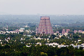
Hinduism is the dominant faith in Palayamkottai. The city has several Hindu temples: the Gopalaswamy temple, Thiripuraanthakaeshwarar temple, Ramar temple, and the Amman temple.
The renovation of the Gopalaswamy temple was completed by the Government of Tamil Nadu recently. It is a Vishnu temple that embodies the cultural and architectural legacy of the city. The herbal wall paintings found inside the sanctum sanctorum are considered to be rare. Built in the 11th century, the institution held its Kumbhabhishekham (consecration ceremony) on 9 July 2009.[3]
Gopalaswamy Temple
A popular mosque in the city is located on the old Police Hospital road, with hundreds of Islamic followers chanting their prayers regularly. Melapalayam is the Muslim quarter of the city, with several mosques and schools.
The city is an epicenter in south Tamil Nadu for Christianity, scattered with a number of churches affiliated to the Tirunelveli Diocese Society of Jesus Jesuits, Church of South India (CSI), others.
Holy Trinity Cathedral
Joseph Constantine Beschi, better known among locals as 'Veeramaamunivar', propagated Christianity in the area. St.Xaviers' Cathedral church, situated at the heart of St. Xaviers' College and established by Jesuit priests, was among the earliest Catholic Churches in Palayamkottai. The St.Xaviers' College church is dedicated to Our Lady of the Assumption.
Major localities in Palayamkottai are Vannarapettai, Murugankuruchi, Market, Samathanapuram, Kamarajar Nagar, Rahmathnagar, Perumalpuram, Maharaja nagar, High Grounds, VM Chatram and KTC Nagar and posh town called Santhi Nagar out of which Vannarpettai, Murugankurichi and Market are concentrated with largely commercial activities. There are also several other minor suburban areas which collectively contribute to the overall cityscape of Palayamkottai.
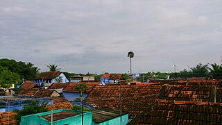
a typical residential area
The little city also has a Government Museum with a huge and realistic fibreglass Tyrannosaurus rex which is popular among the young people of Palayamkottai. The museum houses a small collection of ancient artifacts found in the areas surrounding the city. Some of its literary collections include ancient Tamil inscriptions in palm leaves.[citation needed]
Palayamkottai also has one of the most popular Science Centres in South India, a satellite unit of Visvesvaraya Industrial and Technological Museum, Bangalore. Since the Science Centre lies between Palayamkottai and Tirunelveli (the twin cities) and as it is difficult to mark a border between the two, it is often called as the Tirunelveli District Science Centre (by the district's name). It is a common hangout area for young people, and is frequently visited by teams of school students to explore and learn the principles of science through the centre's interesting outdoor equipment and experiments.[citation needed]
Hospitals
Palayamkottai has many hospitals and other medical facilities. Among them, Our Lady's Hospital, founded nearly 50 years ago by a Belgian nun called Sister Delphine Bruyndonx, was and still remains one of Palayamkottai's popular hospitals for people who are poor or disadvantaged. Sister Delphine was popularly called the Teresa of Tirunelveli by all the people who knew her, because she had served this society since a time when it did not have any electricity.[citation needed]
CSI Bell Pins Mission Hospital and the recently renovated CSI Jeyaraj Annapackiam Hospital in Palayamkottai provide free and reduced cost medical services to the local community. The Tirunelveli Medical college Hospital - a tertiary referral center, located in the High Grounds provides free services to poor people. Palayamkottai also has a specialized kidney care centre and heart surgery centre. The city also has four blood banks.[citation needed]
There is a big market in central Palayamkottai, serviced by many bus routes. Also very popular among locals, is the Ulavar Santhai where farmers sell their products directly. The produce is very fresh and very cheap, and the market is usually very crowded in the morning with eager housewives exercising their haggling skills with the illiterate farmers. The success of the Ulavar Santhai market in Palayamkottai was under a deep speculation during the changing of governments. Now, with the ruling party DMK back in power, (which originally introduced the concept) the Ulavar Santhai is maintained well and is a grocery market for the locals.
Although there are not many supermarkets in Palayamkottai, there are practically all kinds of shops catering to the local people's needs.
Public facilities
Palayamkottai also has a fire-fighting service which conducts camps in local schools annually. The postal service has a statue of Nandhis (mascot of the Indian Postal department) at the facade. It also has the post offices, police stations, big malls, markets, etc.
Palayamkottai has a jail called Palayamkottai Central Prison, which housed several eminent people during the pre-Independence era and afterwards. The Tamil languagepoetSubramanya Bharathi spent a part of his life here. The District Central Jail is notable for its large capacity and tight security. The prison is a popular landmark along the periphery of the city. Even the former Chief Minister, J.Jayalalitha (late) was thrice held in the Palayamkottai jail.
Transportation
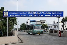
Entrance to Dr. MGR Bus Stand
Palayamkottai Bus Stand, or Palai Bus Stand as it is popularly called by the locals, was the major connecting hub of the City bus network. In 2003, the then Chief minister J.Jayalalithaa inaugurated a major new bus terminal, the Bharat Ratna Dr. MGR Bus Stand, for Tirunelveli in Veinthankulam on Tiruvananthapuram High Road. The new bus terminal connects Palayamkottai and Tirunelveli in an extensive network of neighbouring towns, cities and also the major metropolitan cities of Chennai, Bangalore and Hyderabad. The Palayamkottai bus terminal is also a major stopover for all buses going to Kanyakumari and Nagercoil. There are also numerous connections between the local Palayamkottai bus-stops and Tirunelveli town.
Share-autos (autorickshaws that car-pool paying customers on a common route) ply extensively along Palayamkottai's streets and are easy to flag down. The regular yellow-black Greaves Garuda autorickshaws, although plenty in number, are considered to be the common man's taxis of Palayamkottai. Autorickshaw drivers are known to overcharge tourists. Cars as taxis, are generally only available in taxi stands where tourists and locals use them to travel to short distances outside of the city. As a common practise, people of Palayamkottai or Tirunelveli do not use taxis as an alternate public transportation to buses or trains. Ola taxis have gained popularity with other private taxis as they are cheap than autos.
Palayamkottai has schools for the blind, deaf and mentally handicapped children. These organizations are predominantly run by the Tirunelveli Diocese of Church of South India, and are:
Askwith School for the Visually Handicapped
Florence Swainson School for the Hearing Impaired
Bishop Sargent School for the Mentally Retarded
Colleges
Soon after completing Higher Secondary education, most young people opt for a college education right within the city.
St.John's College – Palayamkottai, Tirunelveli Established in 1844 by Church Missionary Society. In 1878 , it got affiliated by Madars University as second grade college.
St.Xavier's College recently celebrated its 150th anniversary of the Jesuit Priests who founded the great institution. The college has also opened up a new library in 2005 with many modern amenities. The campus also has halls of residences for its large number of resident students. St. Xavier's College of Education and St.John's College are the other xavier institutes with an age restriction for admission, similar to most other colleges in India.
Sarah Tucker College, established in 1895 by the Church Missionary Society , was the first college for women in South India. It is named after Ms.Sarah Tucker, a physically challenged lady confined to her room in England, who was moved by the reports of the appalling condition of the women in this region due to their illiteracy. She stepped in with a crusading spirit to provide education and uplift them. This girls-only college has over eleven departments of education today.
Sports
Palayamkottai has many playgrounds filled with hyperactive young cricketers. Palayamkottai has two major public playgrounds: the "VOC maithanam" and the "Anna Stadium". Grand celebrations during the Republic day and Independence day are conducted by various schools in the VOC ground. State Level Hockey tournaments sponsored by Bell Pins are held in VOC grounds annually. A park and an indoor stadium has been built here in this ground, in order to cover the small children and youngsters. The Anna Stadium holds field hockey and Kabbadi matches at both district and state level. The stadium has an excellent professional German Hockey Turf, which trains a lot of young and energetic teams and Sports Development Authority of Tamil Nadu (SDAT) has recently released tenders for installation of synthetic athletic track in it.[9] The stadium also houses a well maintained swimming pool.
Related Research Articles
Srirangam, is a neighbourhood in the city of Tiruchirappalli in the Indian state of Tamil Nadu. A river island, Srirangam is bounded by the Kaveri River on one side and its distributary Kollidam on the other side. Considered as the first among the 108 Divya Desams, it is famous for Sri Ranganathaswamy Temple, the largest temple complex in India and the biggest functioning Hindu temple in the world. Srirangam is also home to a significant population of Sri Vaishnavites.
Thoothukudi is a port city, a municipal corporation and an industrial city in Thoothukudi district in the Indian state of Tamil Nadu. The city lies in the Coromandel Coast of Bay of Bengal. Thoothukudi is the capital and headquarters of Thoothukudi district. It is located about 590 kilometres southwest of Chennai, 190 kilometres northeast of Thiruvananthapuram and 580 kilometres southeast of Bangalore. According to Confederation of Indian Industry, Thoothukudi has the second highest Human Development Index in Tamil Nadu next to Chennai. Thoothukudi City serves as the headquarters of Tamilnad Mercantile Bank Limited. Major educational establishments in the city include Government Thoothukudi Medical College, Fisheries College and Research Institute, Tamil Nadu Maritime Academy, V.O. Chidambaram College, Kamaraj College, Anna University and Government Polytechnic College. V. O. Chidambaranar Port Trust is one of the fastest growing Major Ports in India. Thoothukudi is an "Emerging Energy and Industrial hub of South India".
Tirunelveli (Tamil: [tiɾɯnelʋeːli], also known as Nellai and historically as Tinnevelly, is a major city in the Indian state of Tamil Nadu. It is the administrative headquarters of the Tirunelveli District. It is the sixth-largest municipal corporation in the state after Chennai, Coimbatore, Madurai, Tiruchirappalli and Salem. Tirunelveli is located 624 km southwest of the state capital Chennai, 58 km away from Thoothukudi, and 73 km from Kanyakumari. The downtown is located on the west bank of the Thamirabarani River; its twin Palayamkottai is on the east bank. Palayamkottai is called the Oxford of South India as it has many schools and colleges. It has several important government offices.
The Thamirabarani or Tamraparni or Porunai is a perennial river that originates from the Agastyarkoodam peak of Pothigai hills of the Western Ghats, above Papanasam in the Ambasamudram taluk. It flows through Tirunelveli and Thoothukudi districts of the Tamil Nadu state of southern India into the Gulf of Mannar. It was called the Tamraparni River in the pre-classical period, a name it lent to the island of Sri Lanka. The old Tamil name of the river is Porunai. From the source to sea, the river is about 128 kilometres (80 mi) long and is the only perennial river in Tamil Nadu. This river flows towards north direction initially. However, it changes to east direction later.
Tirunelveli district is one of the 38 districts of Tamil Nadu state in India. It is the largest district in terms of area with Tirunelveli as its headquarters. The district was formed on 1 September 1790 by the British East India Company, and comprised the present Tirunelveli and Thoothukudi, Tenkasi and parts of Virudhunagar and Ramanathapuram district. As of 2011, the undivided district had a population of 3,077,233.
Nazareth is a town in the Thoothukudi district in the Indian state of Tamil Nadu.
Authoor is a panchayat town in Thoothukudi district of the Indian state of Tamil Nadu.
Cheranmahadevi is a panchayat town in Tirunelveli district in the state of Tamil Nadu, India.
Kadambur is a panchayat town in Kayathar taluk of the Thoothukudi district in the Indian state of Tamil Nadu. The temples in and around Kadambur portray the authentic Chola art and architecture. There is also another village with the same name Kadambur in the district of Salem under Gangavalli taluk.
Kalakad is a Municipality in Tirunelveli district in the Indian state of Tamil Nadu. Kalakad is one of the 3 Municipalities of Tirunelveli District, and is one of the fastest-growing towns in the district.
Sankar Nagar or Thalaiyuthu is a panchayat town in Tirunelveli district in the Indian state of Tamil Nadu. It is located about 8 km north of Tirunelveli on the way to Madurai on highway NH 44. The town is popularly called as Sankar Nagar because of the Sankar Cement factory which initiated settlement in the area.
Tiruvaikuntam is a panchayat town in Thoothukudi district in the Indian state of Tamil Nadu. It is located on the banks of the river Thamirabarani.
Uvari is a coastal village in Thisayanvilai Taluk, Tirunelveli district, Tamil Nadu, India. It is also called Karaichuthu Uvari. The total geographical area of the Uvari is around 3 km2 (1.2 sq mi).
Pettai is an industrial suburban area in Tirunelveli. It is approximately 6 kilometers of downtown Tirunelveli along the Southern Railway line to Tenkasi. It is being administered by the Tirunelveli City Municipal Corporation.
Aazhigudi is a village in the Tuticorin District of Tamil Nadu, India. It is 12 km from Tirunelveli, and the river Thamirabarani passes to the east. It falls under the jurisdiction of Srivaikundam taluk.
Tirunelveli City being the district headquarters of Tirunelveli District in the Indian state of Tamil Nadu has a very extensive transport network. Tirunelveli district is a vital tourist destination with lot of religious places, monuments and hill stations. Tirunelveli is also a major junction for transportation around Tirunelveli, Thoothukudi and Kanyakumari Districts.
Pugalur is a municipality in Karur district in Tamil Nadu, India. It has two parts: Nanjai Pugalur and Punjai Pugalur. Nanjai refers to land with plenty of water, and Punjai refers to land with few bodies of water.
Pappakudi block is a revenue block in the Tirunelveli district of Tamil Nadu, India. It has a total of 15 panchayat villages. Pappakudi a village located in the banks of Thamirabarani river.
Melapalayam is a neighborhood of Tirunelveli City in Tamil Nadu, India situated on the east bank of the Thamirabarani River. The neighborhood's name comes from its location west of Palayamkottai. Eighty percent of the population is Muslim.
Kadanganeri is a village located at Alangulam Taluk in Tenkasi district of Tamil Nadu, India. Kadanganeri is a Village Panchayat comes under Alangulam block.
This page is based on this Wikipedia article Text is available under the CC BY-SA 4.0 license; additional terms may apply. Images, videos and audio are available under their respective licenses.