
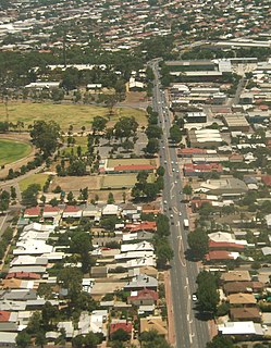
Para Hills is a residential suburb of Adelaide, South Australia. There is a light aircraft airport close to its boundary, and numerous sporting facilities, abundant parks and schools and two medium-sized shopping centres. Most of the suburb is in the City of Salisbury while some is in the City of Tea Tree Gully.
Oxford Falls is a suburb of northern Sydney, in the state of New South Wales, Australia 20 kilometres north-east of the Sydney central business district in the local government area of Northern Beaches Council. Oxford Falls is part of the Northern Beaches region and also considered to be part of the Forest District, colloquially known as The Forest.
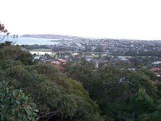
North Manly is a suburb of northern Sydney, in the state of New South Wales, Australia 17 kilometres north-east of the Sydney central business district in the local government area of Northern Beaches Council. It is part of the Northern Beaches region.
North Curl Curl is a suburb in northern Sydney, in the state of New South Wales, Australia 19 kilometres north-east of the Sydney central business district, in the local government area of Northern Beaches Council. It is part of the Northern Beaches region.
Kemps Creek is a suburb of Sydney, in the state of New South Wales, Australia. It is approximately 39 kilometres (24 mi) west of the Sydney central business district, in the local government areas of the City of Penrith and City of Liverpool. It is part of the Greater Western Sydney region.

Londonderry is a suburb of Greater Western Sydney, in the state of New South Wales, Australia. It is 60 kilometres north-west of the Sydney central business district, in the local government area of the City of Penrith.

Westbourne Park is an inner southern suburb of Adelaide, the State capital of South Australia. The suburb was named after Westbourne, a village in Sussex, England, and was laid out in 1881.
Beulah Park is a suburb of Adelaide, South Australia in the City of Burnside.
Payneham is an eastern suburb of Adelaide in the City of Norwood Payneham St Peters. It is part of a string of suburbs in Adelaide's east with a high proportion of Adelaide's Italian-Australian and French-Australian residents, many of whom can be traced back to the large-scale migration following the Second World War.

Plympton Park is a western suburb of Adelaide 8 km from the CBD, in the state of South Australia and falls under the City of Marion. The post code for Plympton Park is 5038. It is adjacent to Park Holme, Plympton, South Plympton, and Morphettville. It is bordered to the east by Marion Road, to the west by Park Terrace, to the south by Taranna Avenue and to the north by the Glenelg tram line.
Pennington is a northern suburb of Adelaide, South Australia, located about 10 km from the Adelaide city centre. It is located in the City of Charles Sturt.
Yatala Vale is an outer northeastern rural suburb of Adelaide, South Australia. It is located in the City of Tea Tree Gully local government area, and is adjacent to Golden Grove and Fairview Park, as well as the rural districts of Upper Hermitage and Gould Creek.

Valley View is a suburb of Adelaide, South Australia. It spans three separate local government areas. They are the City of Salisbury, the City of Port Adelaide Enfield, and the City of Tea Tree Gully. The suburb's boundaries are defined by the intersection of Walkleys, Grand Junction and North East Roads in the south, and Wright and Kelly Roads in the north and east.

Parafield Gardens is a suburb of Adelaide, South Australia. The suburb is largely residential, with a pocket of industrial land in the southwest corner. There are two small shopping centres in the area, one on Salisbury Highway, and another on Sheperdson Road.

Stannifer is a small rural village, on the Northern Tablelands, New South Wales, Australia. The village is situated nine kilometres north of Tingha, New South Wales on the Elsmore Road and is within Inverell Shire. Middle Creek, a tributary of the Macintyre River is nearby.
West Hindmarsh is a suburb of Adelaide, located in the City of Charles Sturt local government area. It is around 4 km west northwest of the Adelaide city centre. It is bounded on the south by the River Torrens, east by South Road, north by Port Road and west by streets separating it from the suburb of Welland which has the same north and south boundaries. Grange Road crosses the middle of the suburb.
Bolivar is an outer northern suburb of Adelaide, South Australia. It is located in the City of Salisbury.
Willaston is a northern suburb 39 kilometres (24 mi) northeast of the Adelaide city centre in South Australia. It is located in the Town of Gawler.

Smithfield Plains is a northern suburb of Adelaide, South Australia in the City of Playford.
Salisbury Downs is a suburb located in the City of Salisbury, Adelaide, South Australia. The suburb is bordered by Kings Road, the Little Para River, Burton Road, Spains Road and the Gawler railway line.


