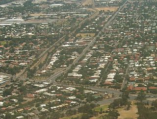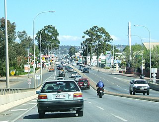
Para Hills is a residential suburb of Adelaide, South Australia. There is a light aircraft airport close to its boundary, and numerous sporting facilities, abundant parks and schools and two medium-sized shopping centres. Most of the suburb is in the City of Salisbury while some is in the City of Tea Tree Gully.

Gulfview Heights is a small suburb of Adelaide, South Australia and is within the City of Salisbury and City of Tea Tree Gully local government area. It is adjacent to Wynn Vale, Salisbury East and Para Hills.

Prospect is the seat of the City of Prospect and an inner northern suburb of greater Adelaide. It is located 5 km (3.1 mi) north of Adelaide's centre.

Enfield is a suburb in Adelaide, Australia. The suburb is about a 10-minute drive north from Adelaide city centre. The suburb is bordered by Gepps Cross to the north, Blair Athol to the west, Clearview to the east, and Prospect, Sefton Park and Broadview to the south.

Greenwith is an outer-north-eastern suburb of Adelaide, the capital city of South Australia, and is within the City of Tea Tree Gully local government area. It is adjacent to Golden Grove and Salisbury Heights. Greenwith is the northernmost part of the Golden Grove urban land development.

Glen Osmond is a suburb of Adelaide, South Australia in the City of Burnside which is in the foothills of the Adelaide Hills. It is well known for the road intersection on the western side of the suburb, where the South Eastern Freeway from the Adelaide Hills and the main route from Melbourne splits into National Route A17 Portrush Road, Glen Osmond Road, Adelaide and state route A3 Cross Road west towards the coast and southern suburbs.

Eastwood is a small triangular inner-southern suburb of Adelaide, South Australia in the City of Burnside.
Kensington Park is an eastern suburb of Adelaide in the City of Burnside in South Australia. It is bordered by Magill Road to the north, Glynburn Road to the east, Kensington Road to the south, and Gurrs and Shipsters Roads to the west.

Cavan is a suburb north of Adelaide, within the City of Salisbury local government area.

Edwardstown is an inner southern-western suburb located 6 km southwest of Adelaide in the City of Marion.
Salisbury East is a suburb of Adelaide, South Australia, located 20 kilometres north of the Adelaide CBD. The residential part of the suburb is in the local government area (LGA) of the City of Salisbury, however the eastern part of the Cobbler Creek Recreation Park is in the boundaries of the City of Tea Tree Gully.

Valley View is a suburb of Adelaide, South Australia. It spans three separate local government areas. They are the City of Salisbury, the City of Port Adelaide Enfield, and the City of Tea Tree Gully. The suburb's boundaries are defined by the intersection of Walkleys, Grand Junction and North East Roads in the south, and Wright and Kelly Roads in the north and east.

Modbury North is a suburb 14 km northeast of Adelaide, capital city of South Australia.

Parafield Gardens is a suburb of Adelaide, South Australia. The suburb is largely residential, with a pocket of industrial land in the southwest corner. There are two small shopping centres in the area, one on Salisbury Highway, and another on Sheperdson Road.

Burton is a small residential suburb approximately 21 kilometres north of the CBD of Adelaide, South Australia. It is located five km north-west of Salisbury in the flat terrain of the Adelaide Plains. The suburb contains two wetland reserves, including Kaurna Park.
Paralowie is a suburb in the north of Adelaide, South Australia, 21.4 km north of the Adelaide city centre. It is predominantly a residential suburb.

Salisbury is a northern suburb in Adelaide, South Australia. It is the seat of the City of Salisbury, and in the South Australian Legislative Assembly electoral district of Ramsay and the Australian House of Representatives division of Spence. The suburb is a service area for the City of Salisbury district, with an abundance of parklands, shops, cafes and restaurants. Parabanks Shopping Centre is also located in Salisbury, which includes Woolworths, Coles and Big W as its signature retailers.
Brahma Lodge is a northern suburb of Adelaide, South Australia. It is located in the City of Salisbury.

Salisbury North is a suburb in the City of Salisbury, part of the greater Adelaide conurbation in South Australia. It was built by the South Australian Housing Trust on a greenfield site in the early 1950s, mainly to house employees of the nearby Long Range Weapons Establishment. It is bounded on the north by the Adelaide–Port Augusta railway line; on the east by the Gawler railway line; on the south by the Little Para River and Waterloo Corner Road; and on the west by Bolivar Road.
Salisbury Downs is a suburb located in the City of Salisbury, Adelaide, South Australia. The suburb is bordered by Kings Road, the Little Para River, Burton Road, Spains Road and the Gawler railway line.


