Pate (Paté) Island (Swahili pronunciation:[ˈpate]) is located in the Indian Ocean close to the northern coast of Kenya, to which it belongs. It is the largest island in the Lamu Archipelago, which lie between the towns of Lamu and Kiunga in the former Coast Province. The island is almost completely surrounded by mangroves.
Like much of the Swahili Coast, Pate's history was marked by a steady transition from agricultural communities in the early first millennium into a specialized, urban trading society around the 10th century, likely earlier. Islam spread down the coast from African Muslims in the Horn of Africa, helping to develop what would be known as the Swahili culture. Despite myths to the contrary, Pate was neither an Arab nor Persian colony, but an African town frequented by trading Arabs, Persians, Indians, and others. It was the centre of the Pate sultanate from the 13th–19th centuries. The Swahili port of Pate long vied with Lamu and Takwa (on Manda Island) for economic dominance of the area, and came into prominence around the 14th century. It was subjugated by Lamu, however, in the late 19th century. [citation needed]
Public transportation is provided by a few mini buses (known as matatus). The main administrative centre on the island, with the police station, is in Faza.
Faza town, on the North coast, known by the name of Ampaza by the Portuguese,[1] dates back at least to the 14th century. In 1587, the Portuguese destroyed Faza, because the local Sheikh had supported Mir Ali Bey, a notorious privateer who had earlier played a key role in ousting the Portuguese from Muscat. The Portuguese arrived from Goa with some 650 men on their punitive expedition, and unleashed their fury on Faza. Everybody they could find was killed, including the local Sheikh. The Portuguese preserved his head in a barrel of salt for display in India. After four days of looting they invited Faza's arch-rivals[who?] from Pate town to take away anything that they liked from Faza.[2]
Faza was later resettled. The Portuguese in Faza constructed a chapel there, however, nothing remains of it. In the 18th century Faza again fell into decline due to the rise of Pate. The English Consul Holmwood visited the place in 1873 and found it "dirty and infected with diseases".[3]
The Pate Sultanate was a sultanate from at least the beginning of the 13th century until 1895. From 1858 on it was the domain known as Wituland. Archeological evidence suggests Pate was a prominent location in local trade networks by the 10th century.[4]
Pate Town is situated on the south-west coast of the island. According to the Pate Chronicle, the town of Pate was founded by refugees from Oman in the 8th century. It was re-founded in 1203 by members of the Nabhani family, also from Oman. The Pate Chronicle also claims that in the 14th century, Pate was so powerful that it had conquered most of the towns on the Swahili coast.[5] However, recent archaeological findings (by Neville Chittick and later, Mark Horton) suggest that the references in the Chronicle to Pate's early history are wrong, and that the town is younger.
The 18th century was known as the "Golden Age of Pate", when the town was at its height of powers and also prospered in fine arts. Builders constructed some of the finest houses on the Swahili coast, with extensive elaborate plaster works. Goldsmiths made intricate jewellery, fine cloths (including silks) were made by Pate's weavers, and carpenters produced fine wooden furniture. The use and production of the musical instrument known as Siwa were most famous. Two examples of Siwas are held in the museum in Lamu.
Both men and women wrote poetry in the Kiamu dialect of Swahili. The Utendi wa Tambuka, one of the earliest known documents in Swahili, was written in the royal Yunga palace in Pate Town. The downfall of Pate town came as a consequence of continuous quarrelling/warring with its neighbours from the end of the 18th century.[6]
In 1811, two British naval officers, Smee and Hardy, visited Pate, and witnessed the infighting.[7]
In 1813, the famous "Battle of Shela" took place at Shela. This was an attempt by Pate, allied with the Mazrui clan from Mombasa/Oman, to subject Lamu. The attempt failed totally, and many were killed. Only a handful of people managed to return to Pate, and their losses were felt for years.[6]
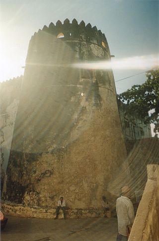
Thomas Boteler, who visited Pate in 1823, described seeing the remains of a Portuguese fort, but said that the place looked otherwise poor.[8] The poet Mwana Kupona (d. 1860) also lived at Pate Town. By 1892, the number of inhabitants had fallen to 300, down from 7,000. Today, the town has recovered some. Agriculture is the main economic activity.[6]
Siyu town is situated on the North coast of Pate island. As no major excavations have been done in Siyu, its age is not known, but it might date from the 13th century. Gaspar de Santo Bernadino visited the town in 1606, and stated that it was the largest town on the island.[9]
Siyu's main claim to historical fame is that it through several battles withstood the Sultans of Zanzibar. In 1843 the Sheikh of Siyu, Bwana Machaka wa Shee, and the new Sheikh of Pate, repudiated the sovereignty of Seyyid Said, Sultan of Oman and Zanzibar. In response, Seyyid Said assembled an army consisting of 2000 people from Muscat, Baluchistan and Lamu. Leading them was his cousin, General Seyyid Hemed bin Ahmed Al-Busaidy, known as "Amir Hemed". He had previously been Governor of Bandar Abbas (in 1824). He landed at Faza in early January 1844. On 6 January they moved towards Siyu, but were ambushed and forced back to Faza. After three weeks without a victory Amir Hemed sailed off.[citation needed]
In 1845 Siyu gave Seyyid Said one of his greatest military defeats, in this battle the famous Amir Hemed was killed and was buried in Rasini where his grave exists to date. Seyyid Said used to pay tribute to his grave at Rasini every year. It is believed Amir Hemed was very swift with his sword to the extent of stopping all arrows and spears shot at him in battlefield. The soldiers of Siu knew about this and during this battle two archers from the Siu army shot two arrows at him in one second targeting his armpit. When Amir Hemed swiftly lifted his sword to stop the first arrow the second shot his chest from the arm pit. It was a poisoned arrow and it killed him instantly. Seyyid Said planned a revenge to avenge the death of his cousin. After a while he cheated almost all the rulers, advisors and generals of Siu into a diplomatic mission with him in Zanzibar, but he turned this into a massacre mission for the rulers of Siu. They were advised by the sultan to leave behind all their weapons since it was a diplomatic one. Upon arrival in Zanzibar, Seyyid Said individually asked every individual in the Siu mission the whereabouts of Amir Hemed and everybody who answered that he is dead was killed instantly by the Sultan. Some of the diplomats who answered that Amir Hemed is still alive were spared but they were imprisoned for life at fort Jesus in Mombasa which was also under the Sultan then. After the Sultan of Zanzibar massacred almost all the rulers of Siu, he forcefully arrested the ones remained in Siu town and deported them to Mombasa for imprisonment at fort Jesus along with the others who survived the Zanzibar Massacre.[citation needed]
When Siyu finally succumbed to Zanzibar's dominance, under Sultan Majid in 1863, it was one of the last towns on the whole of the Swahili Coast to do so.[10]
Kizingitini
Kizingitini is situated on the North coast (east of Faza) and is the largest fishing port on the island. Lying slightly north of Rasini, the fishing port straddles 2° 4'11.90"S and 41° 8'29.92"E, and is the southern reach of the Kizingitini-Kiunga Spiny lobster fishery.
Shanga is an important archaeological site, situated on the South-East coast of the island. It was excavated during an eight-year period, starting in 1980. The earliest settlement was dated to the 8th century, and the conclusion drawn from archaeological evidence (locally minted coins, burials) indicate that a small number of local inhabitants were Muslim, probably from the late 8th century onwards, and at least from the early ninth.[11] The excavations also revealed a major break in the development of Shanga in the mid or late 11th century, with the destruction and the rebuilding of the Friday Mosque[12] Horton relates this to the writing of the historian João de Barros, about members of an Arab tribe, generally believed to be Qarmatians, who arrived at the Swahili coast. De Barros connects these new arrivals with a republican style of government.[13][14]
Shanga was abandoned between 1400–1425; the event was recorded in both the History of Pate and in oral tradition. The Washanga ("the people of Shanga") consist of a clan who still live in the nearby Swahili town of Siyu.[15] Rezende's description of Siyu in 1634 states that "the kingdom of Sio has no king but is ruled by governors"[16]
Evidence of Chinese exploration
In 1999, Nicholas Kristof of the New York Times reported a surprising encounter on the island of Pate. He found a village of stone huts. He talked to an elderly man living in the village who said that he was a descendant of Chinese explorers who were shipwrecked there centuries before. The Chinese had supposedly traded with the locals, and had even loaded giraffes onto their ship to take back to China. However, the Chinese ran aground on a nearby reef. Kristof found evidence that confirmed the man's story. Such evidence included the Asian features of the people in the village, plus Asian-looking porcelain artefacts.[17][18]
National Geographic then published an article by Frank Viviano in July 2005. He had visited Pate island during the time he stayed on Lamu. Ceramic fragments had been found around Lamu, which the administrative officer of the local Swahili history museum claimed were of Chinese origin; specifically, from Zheng He's voyage to the Swahili Coast. The eyes of the Pate people resembled Chinese. Famao and Wei were some of the names among them which were speculated to be of Chinese origin. Their ancestors were said to be from indigenous women who intermarried with Chinese Ming sailors when they were shipwrecked. Two places on Pate were called "Old Shanga", and "New Shanga", which the Chinese sailors had named. A local guide who claimed descent from the Chinese showed Frank a graveyard made out of coral on the island, indicating that they were the graves of the Chinese sailors, which the author described as "virtually identical" to Chinese Ming dynasty tombs, complete with "half-moon domes" and "terraced entries".[19]
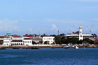
Zanzibar is an insular semi-autonomous region which united with Tanganyika in 1964 to form the United Republic of Tanzania. It is an archipelago in the Indian Ocean, 25–50 km (16–31 mi) off the coast of the African mainland, and consists of many small islands and two large ones: Unguja and Pemba Island. The capital is Zanzibar City, located on the island of Unguja. Its historic centre, Stone Town, is a World Heritage Site.
Stonetown of Zanzibar, also known as Mji Mkongwe, is the old part of Zanzibar City, the main city of Zanzibar, in Tanzania. The newer portion of the city is known as Ng'ambo, Swahili for 'the other side'. Stone Town is located on the western coast of Unguja, the main island of the Zanzibar Archipelago. Former capital of the Zanzibar Sultanate, and flourishing centre of the spice trade as well as the Indian Ocean slave trade in the 19th century, it retained its importance as the main city of Zanzibar during the period of the British protectorate. When Tanganyika and Zanzibar joined each other to form the United Republic of Tanzania, Zanzibar kept a semi-autonomous status, with Stone Town as its local government seat.
The Swahili people comprise mainly Bantu, Afro-Arab, and Comorian ethnic groups inhabiting the Swahili coast, an area encompassing the East African coast across southern Somalia, Kenya, Tanzania, and northern Mozambique, and various archipelagos off the coast, such as Zanzibar, Lamu, and the Comoro Islands.
Lamu or Lamu Town is a small town on Lamu Island, which in turn is a part of the Lamu Archipelago in Kenya. Situated 341 kilometres (212 mi) by road northeast of Mombasa that ends at Mokowe Jetty, from where the sea channel has to be crossed to reach Lamu Island, it is the headquarter of Lamu County and a UNESCO World Heritage Site.
Wituland was a territory of approximately 3,000 square kilometres (1,200 sq mi) in East Africa centered on the town of Witu, just inland from the Indian Ocean port of Lamu, north of the mouth of the Tana River in what is now Kenya.
The Lamu Archipelago is located in the Indian Ocean close to the northern coast of Kenya, to which it belongs. The islands lie between the towns of Lamu and Kiunga, near the Coast Province. It is a part of Lamu District.
Lamu Island is a port, city, and island just off the shore of Kenya in the Indian Ocean approximately 150 miles from Mombasa. It is a part of the East African country of Kenya. Lamu was founded in the 12th century. Lamu is one of the longest-established and best-preserved remaining settlements of the Swahili tradition in east Africa that remains today. The island has continually been inhabited for over seven hundred years, and continues to be an important center in eastern Africa.
Swahili architecture is a term used to designate a whole range of diverse building traditions practiced or once practiced along the eastern and southeastern coasts of Africa. Rather than simple derivatives of Islamic architecture from the Arabic world, Swahili stone architecture is a distinct local product as a result of evolving social and religious traditions, environmental changes, and urban development.
The Kilwa Sultanate was a sultanate, centered at Kilwa, whose authority, at its height, stretched over the entire length of the Swahili Coast. According to the legend, it was founded in the 10th century by Ali ibn al-Hassan Shirazi, a Persian prince of Shiraz.
The Ottoman–Portuguese Conflicts (1586–1589) were armed military engagements which took place between the Portuguese Empire and the Ottoman Empire along the coast of eastern Africa.
Mwana Kupona binti Msham was a Swahili poet of the 19th century, author of a poem called Utendi wa Mwana Kupona, which is one of the most well-known works of early Swahili literature.
The Swahili coast is a coastal area of Southeast Africa, bordered by the Indian Ocean and inhabited by the Swahili people. It includes Sofala ; Mombasa, Gede, Pate Island, Lamu, and Malindi ; and Dar es Salaam and Kilwa. In addition, several coastal islands are included in the Swahili coast, such as Zanzibar and Comoros.
Tumbatu is a historic Swahili settlement located on Tumbatu Island, Kaskazini A District of Unguja North Region in Tanzania. This site is a significant archaeological site that contains a large number of collapsed coral stone structures including private houses and several mosques, the largest of which is located on the shore facing the village of Mkokotoni on Unguja. Pearce initially looked into the ruins in 1915 and wrote about the mosques, palace, and other stone homes.
Faza is a small town on the North coast on Pate Island, within the Lamu Archipelago in Kenya's former Coast Province.
Siyu is a settlement on the north coast of Pate Island, within the Lamu Archipelago in Kenya's Coast Province.
Lamu Fort is a fortress in the town of Lamu in northeastern Kenya. Originally situated on the waterfront, the fort today is located in a central position in the town, about 70 metres (230 ft) from the main jetty on the shore.
The Battle of Shela occurred around 1812 on the sand dunes near the village of Shela on Lamu Island, in what is now Kenya, just south of the larger village of Lamu. The people of Lamu won against superior forces from Mombasa and Pate. The battle led to the domination of the coast by the rulers of Oman.
Rasini, also known as Kikoni, is a small town in the southern Lower Juba province of Somalia.
Shanga is an archaeological site located in Pate Island off the eastern coast of Africa. The site covers about 15 hectares. Shanga was excavated during an eight-year period in which archaeologists examined Swahili origins. The archaeological evidence in the form of coins, pottery, glass and beads all suggest that a Swahili community inhabited the area during the eighth century. Evidence from the findings also indicates that the site was a Muslim trading community that had networks in Asia.
Maritime archaeology in East Africa spans the range from the horn of Somalia south to Mozambique, and includes the various islands and island chains dotting the map off the coast of Somalia, Mozambique, Tanzania and Kenya. Primary areas along this coast include the Zanzibar, Lamu, and Kilwa Archipelagos. Although East African societies developed nautical capabilities for themselves, most of the maritime artifacts point to external merchants from Mediterranean cultures like Egypt and Greece, Indian and Chinese from South and East Asia in the early stages, to the great European powers during the Ages of Colonization and Imperialism.
References
↑ Svat Soucek, " The Portuguese and the Turks in the Persian gulf " in Studies in Ottoman Naval History and Maritime Geography., Analecta isisiana, n°102, The Isis press, Istanbul, 2008. ISBN978-975-428-365-5, p. 101-106.
Martin, Chryssee MacCasler Perry and Esmond Bradley Martin: Quest for the Past. An historical guide to the Lamu Archipelago. 1973.
Mark Horton; with contributions by Helen W. Brown and Nina Mudida: Shanga: the archaeology of a Muslim trading community on the coast of East Africa. Memoirs of the British Institute in Eastern Africa; No. 14 London: British Institute in Eastern Africa, 1996. ISBN1-872566-09-X
Brown, H. (1985) History of Siyu: the development and decline of a Swahili town on the northern Swahili coast. Unpublished PhD thesis, Indiana University.
Brown, H. (1988) Siyu: town of the craftsmen. Azania 26, pp 1–4.
Freeman-Grenville (1962) The East-African coast: select documents from the first to the earlier nineteenth century. London: Oxford University Press.
Kirkman, James: Men and Monuments on the East African Coast .
King'ei Kitula: Mwana Kupona: Poetess from Lamu,ISBN9966-951-05-9, Sasa Sema Publications, 2000.
Strandes, Justus: The Portuguese Period in East Africa.
Tolmacheva, Marina; Weiler, Dagmar (translator): The Pate Chronicle: Edited and Translated from Mss 177, 321, 344, and 358 of the Library of the University of Dar Es Salaam (African Historical Sources) ISBN0-87013-336-5
Werner, A; Hichens, W: The Advice of Mwana Kupona upon The Wifely Duty, Azania Press, 1934.
This page is based on this Wikipedia article Text is available under the CC BY-SA 4.0 license; additional terms may apply. Images, videos and audio are available under their respective licenses.