Pecorara

Last updated
Pecorara
Comune
Comune di Pecorara
Italy provincial location map 2015.svg
Red pog.svg
Pecorara
Location of Pecorara in Italy
Coordinates: 44°53′N9°23′E / 44.883°N 9.383°E / 44.883; 9.383 Coordinates: 44°53′N9°23′E / 44.883°N 9.383°E / 44.883; 9.383
Country Italy
Region Emilia-Romagna
Province Province of Piacenza (PC)
Frazioni Cicogni, Praticchia, Busseto, Costalta, Sevizzano, Marzonago, Montemartino, Morasco, Roncaglie
Area
  Total 53.8 km2 (20.8 sq mi)
Population (Dec. 2004)
  Total 884
  Density 16/km2 (43/sq mi)
Demonym(s) Pecoraresi
Time zone CET (UTC+1)
  Summer (DST) CEST (UTC+2)
Postal code29010
Dialing code 0523
Website Official website

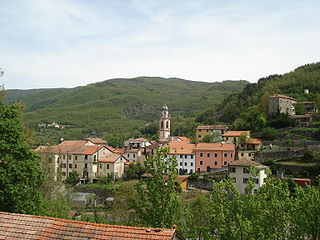
Pecorara is a comune (municipality) in the Province of Piacenza in the Italian region Emilia-Romagna, located about 160 kilometres (99 mi) northwest of Bologna and about 30 kilometres (19 mi) southwest of Piacenza. As of 31 December 2004, it had a population of 884 and an area of 53.8 square kilometres (20.8 sq mi). [1]

<i>Comune</i> third-level administrative divisions of the Italian Republic

The comune is a basic administrative division in Italy, roughly equivalent to a township or municipality.

Province of Piacenza Province of Italy

The province of Piacenza is a province in the Emilia-Romagna region of Italy. Its provincial capital is the city Piacenza. As of 2016, it has a total population of 286,572 inhabitants over an area of 2,585.86 square kilometres (998.41 sq mi), giving it a population density of 111.38 inhabitants per square kilometre. The city Piacenza has a population of 102,269, as of 2015. The provincial president is Patrizia Barbieri and it contains 48 comuni. The province dates back to its founding by the Romans in 218 BCE.

Italy republic in Southern Europe

Italy, officially the Italian Republic, is a European country consisting of a peninsula delimited by the Italian Alps and surrounded by several islands. Located in the middle of the Mediterranean sea and traversed along its length by the Apennines, Italy has a largely temperate seasonal climate. The country covers an area of 301,340 km2 (116,350 sq mi) and shares open land borders with France, Slovenia, Austria, Switzerland and the enclaved microstates of Vatican City and San Marino. Italy has a territorial exclave in Switzerland (Campione) and a maritime exclave in the Tunisian sea (Lampedusa). With around 60 million inhabitants, Italy is the fourth-most populous member state of the European Union.

Contents

The municipality of Pecorara contains the frazioni (subdivisions, mainly villages and hamlets) Cicogni, Praticchia, Busseto, Costalta, Sevizzano, Marzonago, Montemartino, Morasco, and Roncaglie.

"Frazione" is the Italian name given in administrative law to a type of territorial subdivision of a comune; for other administrative divisions, see municipio, circoscrizione, quartiere. It is cognate to the English word fraction, but in practice is roughly equivalent to "parishes" or "wards" in other countries.

Cicogni is a town in the comune of Alta Val Tidone in the Italian region Emilia-Romagna, located about 40 km southwest of Piacenza.

Pecorara borders the following municipalities: Bobbio, Nibbiano, Pianello Val Tidone, Piozzano, Romagnese, Travo, Zavattarello.

Bobbio Comune in Emilia-Romagna, Italy

Bobbio is a small town and commune in the province of Piacenza in Emilia-Romagna, northern Italy. It is located in the Trebbia River valley southwest of the town Piacenza. There is also an abbey and a diocese of the same name. Bobbio is the administrative center of the Unione Montana Valli Trebbia e Luretta.

Nibbiano Italian comune

Nibbiano is a former comune (municipality) in the Province of Piacenza in the Italian region Emilia-Romagna. On 1 January, it was merged with Caminata and Pecorara into the new comune of Alta Val Tidone.

Pianello Val Tidone Comune in Emilia-Romagna, Italy

Pianello Val Tidone is a comune (municipality) in the Province of Piacenza in the Italian region Emilia-Romagna, located about 160 kilometres (99 mi) northwest of Bologna and about 25 kilometres (16 mi) southwest of Piacenza.

Demographic evolution

Pecorara

Related Research Articles

Piacenza dAdige Comune in Veneto, Italy

Piacenza d'Adige is a comune (municipality) in the Province of Padua in the Italian region Veneto, located about 70 kilometres (43 mi) southwest of Venice and about 40 kilometres (25 mi) southwest of Padua. As of 31 December 2004, it had a population of 1,371 and an area of 18.6 square kilometres (7.2 sq mi).

Agazzano Comune in Emilia-Romagna, Italy

Agazzano is a comune (municipality) in the Province of Piacenza in the Italian region Emilia-Romagna, located about 150 kilometres (93 mi) northwest of Bologna and about 20 kilometres (12 mi) southwest of Piacenza. As of 31 December 2004, it had a population of 2,021 and an area of 35.9 square kilometres (13.9 sq mi).

Calendasco Comune in Emilia-Romagna, Italy

Calendasco is a comune (municipality) in the Province of Piacenza in the Italian region Emilia-Romagna, located about 150 kilometres (93 mi) northwest of Bologna and about 9 kilometres (6 mi) northwest of Piacenza.

Caminata Italian comune

Caminata is a town and former comune (municipality) in the Province of Piacenza in the Italian region Emilia-Romagna, located about 170 kilometres (110 mi) northwest of Bologna and about 35 kilometres (22 mi) southwest of Piacenza. It is now part of the comune of Alta Val Tidone.

Caorso Comune in Emilia-Romagna, Italy

Caorso is a comune (municipality) in the Province of Piacenza in the Italian region Emilia-Romagna, located about 130 kilometres (81 mi) northwest of Bologna and about 13 kilometres (8 mi) east of Piacenza.

Cerignale Comune in Emilia-Romagna, Italy

Cerignale is a comune (municipality) in the Province of Piacenza in the Italian region Emilia-Romagna, located about 160 kilometres (99 mi) west of Bologna and about 50 kilometres (31 mi) southwest of Piacenza. As of 31 December 2004, it had a population of 197 and an area of 31.5 square kilometres (12.2 sq mi).

Coli, Emilia-Romagna Comune in Emilia-Romagna, Italy

Coli is a comune (municipality) in the Province of Piacenza in the Italian region Emilia-Romagna, located about 160 kilometres (99 mi) west of Bologna and about 40 kilometres (25 mi) southwest of Piacenza. As of 31 December 2004, it had a population of 1,030 and an area of 72.2 square kilometres (27.9 sq mi).

Corte Brugnatella Comune in Emilia-Romagna, Italy

Corte Brugnatella is a comune (municipality) in the Province of Piacenza in the Italian region Emilia-Romagna, located about 160 kilometres (99 mi) west of Bologna and about 45 kilometres (28 mi) southwest of Piacenza.

Farini, Emilia-Romagna Comune in Emilia-Romagna, Italy

Farini is a comune (municipality) in the Province of Piacenza in the Italian region Emilia-Romagna, located about 140 kilometres (87 mi) west of Bologna and about 40 kilometres (25 mi) southwest of Piacenza. As of 31 December 2004, it had a population of 1,744 and an area of 112.0 square kilometres (43.2 sq mi).

Gazzola Comune in Emilia-Romagna, Italy

Gazzola is a comune (municipality) in the Province of Piacenza in the Italian region Emilia-Romagna, located about 150 kilometres (93 mi) northwest of Bologna and about 15 kilometres (9 mi) southwest of Piacenza. As of 31 December 2004, it had a population of 1,856 and an area of 44.1 square kilometres (17.0 sq mi).

Gossolengo Comune in Emilia-Romagna, Italy

Gossolengo is a comune (municipality) in the province of Piacenza in the Italian region Emilia-Romagna, located about 150 kilometres (93 mi) northwest of Bologna and about 9 kilometres (6 mi) southwest of Piacenza, in the valley of the Trebbia river.

Morfasso Comune in Emilia-Romagna, Italy

Morfasso is a comune (municipality) in the Province of Piacenza in the Italian region Emilia-Romagna, located about 130 kilometres (81 mi) west of Bologna and about 35 kilometres (22 mi) south of Piacenza. As of 31 December 2011, it had a population of 1,090 and an area of 83.6 square kilometres (32.3 sq mi).

Ottone, Emilia-Romagna Comune in Emilia-Romagna, Italy

Ottone is a comune (municipality) in the Province of Piacenza in the Italian region Emilia-Romagna, located about 160 kilometres (99 mi) west of Bologna and about 60 kilometres (37 mi) southwest of Piacenza, in the upper Val Trebbia on the Ligurian Apennine. Ottone is the westernmost comune of Emilia-Romagna. The Mount Alfeo is located in its territory.

Pontenure Comune in Emilia-Romagna, Italy

Pontenure is a comune (municipality) in the Province of Piacenza in the Italian region Emilia-Romagna, located about 140 kilometres (87 mi) northwest of Bologna and about 9 kilometres (6 mi) southeast of Piacenza.

Rivergaro Comune in Emilia-Romagna, Italy

Rivergaro is a comune (municipality) in the Province of Piacenza in the Italian region Emilia-Romagna, located about 150 kilometres (93 mi) northwest of Bologna and about 20 kilometres (12 mi) southwest of Piacenza. As of 31 December 2011, it had a population of 6,843 and an area of 43.8 square kilometres (16.9 sq mi).

San Giorgio Piacentino Comune in Emilia-Romagna, Italy

San Giorgio Piacentino is a comune (municipality) in the Province of Piacenza in the Italian region Emilia-Romagna, located about 140 kilometres (87 mi) northwest of Bologna and about 11 kilometres (7 mi) south of Piacenza.

San Pietro in Cerro Comune in Emilia-Romagna, Italy

San Pietro in Cerro is a comune (municipality) in the Province of Piacenza in the Italian region Emilia-Romagna, located about 120 kilometres (75 mi) northwest of Bologna and about 20 kilometres (12 mi) east of Piacenza. As of 31 December 2004, it had a population of 962 and an area of 27.5 square kilometres (10.6 sq mi).

Zerba Comune in Emilia-Romagna, Italy

Zerba is a comune (municipality) in the Province of Piacenza in the Italian region Emilia-Romagna, located about 170 kilometres (110 mi) west of Bologna and about 50 kilometres (31 mi) southwest of Piacenza. As of 31 December 2004, it had a population of 123 and an area of 25.0 square kilometres (9.7 sq mi).

Santo Stefano Lodigiano Comune in Lombardy, Italy

Santo Stefano Lodigiano is a comune (municipality) in the Province of Lodi in the Italian region Lombardy, located about 60 kilometres (37 mi) southeast of Milan and about 25 kilometres (16 mi) southeast of Lodi.

Alta Val Tidone Comune in Emilia-Romagna, Italy

Alta Val Tidone is a new comune (municipality) in the Province of Piacenza in the Italian region Emilia-Romagna, located about 180 kilometres (110 mi) northwest of Bologna and about 30 kilometres (19 mi) southwest of Piacenza.

References

  1. All demographics and other statistics: Italian statistical institute Istat.