Related Research Articles

Camborne is a town in Cornwall, England. The population at the 2011 Census was 20,845. The northern edge of the parish includes a section of the South West Coast Path, Hell's Mouth and Deadman's Cove.
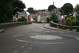
Coombe is a hamlet in west Cornwall, England, United Kingdom. It is situated two miles (3 km) north of the town of Camborne in the valley of the Red River at grid reference SW 629 424.

Goldsithney is a village in west Cornwall, England, United Kingdom. It is on the B3280 at grid reference SW546306, about four miles (6 km) east of Penzance and one mile (1.6 km) east of Marazion. It is in the civil parish of Perranuthnoe.
Mylor Bridge is a village in Cornwall, England, United Kingdom. It is in Mylor civil parish at the head of Mylor Creek, about five miles north of Falmouth.
Carnyorth is a hamlet in west Cornwall, England, United Kingdom. It is approximately one mile (1.6 km) south of Pendeen and six miles (10 km) northwest of Penzance. It is in the civil parish of St Just in Penwith

Gwinear–Gwithian is a coastal civil parish in west Cornwall, England, United Kingdom. It includes the villages of Connor Downs, Gwinear, Gwithian, Reawla and Rosewarne. The parish is situated approximately two miles (3 km) east of Hayle two miles (3 km) west of Camborne.
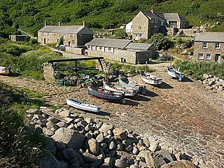
Penberth is a valley, coastal village and cove on the Penwith peninsula in Cornwall, England. It is approximately 7 miles (11 km) southwest of Penzance. Most of the village is within the parish of St Buryan and the boundary with St Levan follows the Penberth river.

Manaccan is a civil parish and village on the Lizard peninsula in south Cornwall, England, United Kingdom. The village is about five miles (8 km) south-southwest of Falmouth.

Crows-an-Wra is a hamlet in West Cornwall, England, United Kingdom. It is situated in the civil parish of St Buryan, Lamorna and Paul approximately four miles (6 km) northeast of Land's End.

Newbridge is a hamlet in the civil parish of Madron on the Penwith peninsula in west Cornwall, England, United Kingdom. It is on the A3071 road between St Just and Penzance, about three miles (5 km) west of the latter.

Troon is a village in Cornwall, UK, 1+1⁄2 miles southeast of Camborne. The village lies at around 560 feet (170 m) above sea level. An electoral ward named Troon and Beacon covers the area north from Troon to the outskirts of Camborne. The population at the 2011 census was 5,410.

Brea is a village in Cornwall, England, UK, between the towns of Camborne and Redruth. It is in the civil parish of Carn Brea and consists of Brea, Lower Brea, and Higher Brea. A small stream, the Red River, flows through the village and a hill, Carn Brea dominates the landscape to the east, along with its monument to Francis Basset.
Bridge is a village in Cornwall, England, United Kingdom. It is in the civil parish of Portreath and lies about 1 km east of Portreath village and harbour. The population of Bridge is not recorded separately in censuses, and makes up a small proportion of the 1,581 living in the parish as a whole.

Calenick is a hamlet in the civil parish of Kea, about a mile south of Truro in Cornwall, England, UK. It is at the head of Calenick Creek, which opens into the River Truro near Sunny Corner.

Kehelland is a hamlet northwest of Camborne in west Cornwall, England.

Camborne Treslothan was an electoral division of Cornwall in the United Kingdom which returned one member to sit on Cornwall Council between 2013 and 2021. It was abolished at the 2021 local elections, being succeeded by Four Lanes, Beacon and Troon.

Camborne Treswithian was an electoral division of Cornwall in the United Kingdom which returned one member to sit on Cornwall Council between 2013 and 2021. It was abolished at the 2021 local elections, being succeeded by Camborne West and Treswithian.

Camborne Roskear was an electoral division of Cornwall in the United Kingdom which returned one member to sit on Cornwall Council between 2013 and 2021. It was abolished at the 2021 local elections, being succeeded by Camborne Roskear and Tuckingmill.
Camborne Trelowarren is an electoral division of Cornwall in the United Kingdom and returns one member to sit on Cornwall Council. The current Councillor is Paul White, an Independent. The current division is distinct from that of the same name used from 2013 to 2021, after boundary changes at the 2021 local elections.
Four Lanes, Beacon and Troon is an electoral division of Cornwall in the United Kingdom which returns one member to sit on Cornwall Council. It was created at the 2021 local elections, being created from the former divisions of Camborne Treslothan and Four Lanes. The current councillor is Sally Weedon, a Conservative.
References
- ↑ Place-names in the Standard Written Form (SWF) Archived 15 May 2013 at the Wayback Machine : List of place-names agreed by the MAGA Signage Panel Archived 15 May 2013 at the Wayback Machine . Cornish Language Partnership.
- ↑ Ordnance Survey: Landranger map sheet 203 Land's End & Isles of Scilly (St Ives & Lizard Point) (Map). Ordnance Survey. 2009. ISBN 978-0-319-23289-7.
- ↑ Ordnance Survey One-inch Map of Great Britain; Land's End, sheet 189. 1961
- ↑ "E05 Electoral Ward/Division Camborne Treslothan". Office for National Statistics . Retrieved 5 June 2021.
- ↑ "Cornwall Council Interactive Map". Cornwall Council . Retrieved 5 June 2021.
| Unitary authorities | |
|---|---|
| Major settlements (cities in italics) |
|
| Rivers | |
| Topics | |
50°12′40″N5°17′13″W / 50.211°N 5.287°W
| | This Cornwall location article is a stub. You can help Wikipedia by expanding it. |