Pescolanciano

Last updated
Pescolanciano
Comune
Comune di Pescolanciano
Pescolanciano.jpg
View of Pescolanciano
Italy provincial location map 2015.svg
Red pog.svg
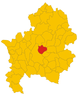
Pescolanciano
Location of Pescolanciano in Italy
Coordinates: 41°41′N14°20′E / 41.683°N 14.333°E / 41.683; 14.333 Coordinates: 41°41′N14°20′E / 41.683°N 14.333°E / 41.683; 14.333
Country Italy
Region Molise
Province Isernia (IS)
Frazioni lLa Castagna
Government
  Mayor Manolo Sacco
Area
  Total 34.73 km2 (13.41 sq mi)
Elevation 800 m (2,600 ft)
Population (30 September 2016) [1]
  Total 847
  Density 24/km2 (63/sq mi)
Demonym(s) Pescolancianesi
Time zone CET (UTC+1)
  Summer (DST) CEST (UTC+2)
Postal code86097
Dialing code 0865
Website Official website

Pescolanciano is a comune (municipality) in the Province of Isernia in the Italian region Molise, located about 30 kilometres (19 mi) northwest of Campobasso and about 12 kilometres (7 mi) northeast of Isernia.

<i>Comune</i> third-level administrative divisions of the Italian Republic

The comune is a basic administrative division in Italy, roughly equivalent to a township or municipality.

Province of Isernia Province of Italy

The province of Isernia is a province in the region of Molise in Italy. The provincial capital is the city Isernia and the president of the province is Luigi Brasiello. The province of Isernia has an area of 1,535.24 square kilometres (592.76 sq mi) and a population of 86,405 inhabitants as of 2016. It contains 52 comunes in the province, listed at comunes of the Province of Isernia.

Italy republic in Southern Europe

Italy, officially the Italian Republic, is a European country consisting of a peninsula delimited by the Italian Alps and surrounded by several islands. Located in the middle of the Mediterranean sea and traversed along its length by the Apennines, Italy has a largely temperate seasonal climate. The country covers an area of 301,340 km2 (116,350 sq mi) and shares open land borders with France, Slovenia, Austria, Switzerland and the enclaved microstates of Vatican City and San Marino. Italy has a territorial exclave in Switzerland (Campione) and a maritime exclave in the Tunisian sea (Lampedusa). With around 60 million inhabitants, Italy is the fourth-most populous member state of the European Union.

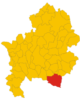
Pescolanciano borders the following municipalities: Agnone, Carovilli, Chiauci, Civitanova del Sannio, Miranda, Pietrabbondante, Sessano del Molise.

Agnone Comune in Molise, Italy

Agnone is a comune in the province of Isernia, in the Molise region of southern Italy. Agnone is known for the manufacturing of bells by the Marinelli Bell Foundry. It is some 53 kilometres (33 mi) northwest of Campobasso. The town of Agnone proper is complemented with other populated centers like Fontesambuco, Villa Canale and Rigaini.

Carovilli Comune in Molise, Italy

Carovilli is a comune (municipality) in the Province of Isernia in the Italian region Molise, located about 35 kilometres (22 mi) northwest of Campobasso and about 14 kilometres (8.7 mi) northeast of Isernia. As of 31 December 2004, it had a population of 1,508 and an area of 41.6 square kilometres (16.1 sq mi).

Chiauci Comune in Molise, Italy

Chiauci is a comune (municipality) in the Province of Isernia in the Italian region Molise, located about 25 kilometres (16 mi) northwest of Campobasso and about 15 kilometres (9 mi) northeast of Isernia.

Sights include the Castello D'Alessandro, built perhaps around 583 duing the reign of Lombard king Alboin, or later under Charlemagne. The first historical mentions are from the 13th century. Located on the spur overlooking the town, it has a massive pentagonal plan.

Lombards Historical ethnical group

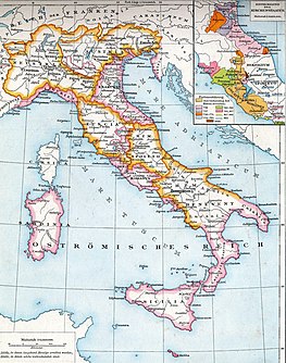
The Lombards or Longobards were a Germanic people who ruled most of the Italian Peninsula from 568 to 774.

Alboin King of the Lombards

Alboin was king of the Lombards from about 560 until 572. During his reign the Lombards ended their migrations by settling in Italy, the northern part of which Alboin conquered between 569 and 572. He had a lasting effect on Italy and the Pannonian Basin; in the former his invasion marked the beginning of centuries of Lombard rule, and in the latter his defeat of the Gepids and his departure from Pannonia ended the dominance there of the Germanic peoples.

Charlemagne King of the Franks, King of Italy, and Holy Roman Emperor

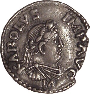
Charlemagne or Charles the Great, numbered Charles I, was king of the Franks from 768, king of the Lombards from 774, and emperor of the Romans from 800. He united much of western and central Europe during the Early Middle Ages. He was the first recognised emperor to rule from western Europe since the fall of the Western Roman Empire three centuries earlier. The expanded Frankish state that Charlemagne founded is called the Carolingian Empire. He was later canonized by Antipope Paschal III.

Related Research Articles

Bagnoli del Trigno Comune in Molise, Italy

Bagnoli del Trigno is a comune (municipality) in the Province of Isernia in the Italian region Molise, located about 25 kilometres (16 mi) northwest of Campobasso and about 20 kilometres (12 mi) northeast of Isernia.

Belmonte del Sannio Comune in Molise, Italy

Belmonte del Sannio is a comune (municipality) in the Province of Isernia in the Italian region Molise, located about 35 kilometres (22 mi) northwest of Campobasso and about 30 kilometres (19 mi) northeast of Isernia.

Carpinone Comune in Molise, Italy

Carpinone is a comune (municipality) in the Province of Isernia in the Italian region Molise, located about 30 kilometres (19 mi) west of Campobasso and about 7 kilometres (4 mi) east of Isernia. As of 31 December 2004, it had a population of 1,273 and an area of 32.5 square kilometres (12.5 sq mi).

Castel del Giudice Comune in Molise, Italy

Castel del Giudice is a comune (municipality) in the Province of Isernia in the Italian region of Molise, located about 50 kilometres (31 mi) northwest of Campobasso and about 30 kilometres (19 mi) north of Isernia.

Castelpetroso Comune in Molise, Italy

Castelpetroso is a comune (municipality) in the Province of Isernia in the Italian region Molise, located about 25 kilometres (16 mi) west of Campobasso and about 10 kilometres (6 mi) southeast of Isernia. As of 31 December 2004, it had a population of 1,708 and an area of 22.6 square kilometres (8.7 sq mi).

Castelpizzuto Comune in Molise, Italy

Castelpizzuto is a comune (municipality) in the Province of Isernia in the Italian region Molise, located about 30 kilometres (19 mi) west of Campobasso and about 11 kilometres (7 mi) southeast of Isernia. As of 31 December 2004, it had a population of 156 and an area of 15.2 square kilometres (5.9 sq mi).

Civitanova del Sannio Comune in Molise, Italy

Civitanova del Sannio is a comune (municipality) in the Province of Isernia in the Italian region Molise, located about 25 kilometres (16 mi) northwest of Campobasso and about 15 kilometres (9 mi) northeast of Isernia.

Conca Casale Comune in Molise, Italy

Conca Casale is a comune (municipality) in the Province of Isernia in the Italian region Molise, located about 50 kilometres (31 mi) west of Campobasso and about 20 kilometres (12 mi) southwest of Isernia.

Forlì del Sannio Comune in Molise, Italy

Forlì del Sannio is a comune (municipality) in the Province of Isernia in the Italian region Molise, located about 45 kilometres (28 mi) northwest of Campobasso and about 12 kilometres (7 mi) northwest of Isernia.

Longano Comune in Molise, Italy

Longano is a comune (municipality) in the Province of Isernia in the Italian region of Molise, located about 35 kilometres (22 mi) west of Campobasso and about 9 kilometres (6 mi) south of Isernia. As of 31 December 2004, it had a population of 720 and an area of 27.1 square kilometres (10.5 sq mi).

Miranda, Molise Comune in Molise, Italy

Miranda is a comune (municipality) in the Province of Isernia in the Italian region Molise, located about 35 kilometres (22 mi) northwest of Campobasso and about 6 kilometres (4 mi) north of Isernia. As of 31 December 2004, it had a population of 1,065 and an area of 22.3 square kilometres (8.6 sq mi).

Pesche Comune in Molise, Italy

Pesche is a comune (municipality) in the Province of Isernia in the Italian region Molise, located about 30 kilometres (19 mi) west of Campobasso and about 5 kilometres (3 mi) northeast of Isernia. As of 31 December 2004, it had a population of 1,459 and an area of 12.7 square kilometres (4.9 sq mi).

Pettoranello del Molise Comune in Molise, Italy

Pettoranello del Molise is a comune (municipality) in the Province of Isernia in the Italian region Molise, located about 30 kilometres (19 mi) west of Campobasso and about 6 kilometres (4 mi) southeast of Isernia.

Roccamandolfi Comune in Molise, Italy

Roccamandolfi is a comune (municipality) in the Province of Isernia in the Italian region Molise, located about 25 kilometres (16 mi) southwest of Campobasso and about 15 kilometres (9 mi) southeast of Isernia.

Roccasicura Comune in Molise, Italy

Roccasicura is a comune (municipality) in the Province of Isernia in the Italian region Molise, located about 40 kilometres (25 mi) northwest of Campobasso and about 11 kilometres (7 mi) north of Isernia. As of 31 December 2004, it had a population of 610 and an area of 29.0 square kilometres (11.2 sq mi).

SantAngelo del Pesco Comune in Molise, Italy

Sant'Angelo del Pesco is a comune (municipality) in the Province of Isernia in the Italian region Molise, located about 50 kilometres (31 mi) northwest of Campobasso and about 30 kilometres (19 mi) north of Isernia.

Sessano del Molise Comune in Molise, Italy

Sessano del Molise is a comune (municipality) in the Province of Isernia in the Italian region Molise, located about 30 kilometres (19 mi) northwest of Campobasso and about 9 kilometres (6 mi) northeast of Isernia. As of 31 December 2004, it had a population of 871 and an area of 24.7 square kilometres (9.5 sq mi).

Vastogirardi Comune in Molise, Italy

Vastogirardi is a comune (municipality) in the Province of Isernia in the Italian region Molise, located about 40 kilometres (25 mi) northwest of Campobasso and about 20 kilometres (12 mi) north of Isernia. As of 31 December 2004, it had a population of 789 and an area of 60.9 square kilometres (23.5 sq mi).

References

  1. All demographics and other statistics: Italian statistical institute Istat.