Petite Rivière

Last updated
Petite Rivière
PetiteRiviereNS2004.jpg
Petite Rivière
Location
Country Canada
Physical characteristics
Mouth  
 - location
Green Bay
 - elevation
Sea level
Basin size244 km2 (94 sq mi)

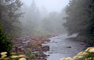
Petite Rivière is a river in Nova Scotia, Canada entirely within Lunenburg County. It is fed by numerous lakes, and a portion of the watershed is the drinking water supply for the town of Bridgewater.

Nova Scotia Province of Canada

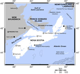
Nova Scotia is one of Canada's three Maritime Provinces, and one of the four provinces that form Atlantic Canada. Its provincial capital is Halifax. Nova Scotia is the second-smallest of Canada's ten provinces, with an area of 55,284 square kilometres (21,300 sq mi), including Cape Breton and another 3,800 coastal islands. As of 2016, the population was 923,598. Nova Scotia is Canada's second-most-densely populated province, after Prince Edward Island, with 17.4 inhabitants per square kilometre (45/sq mi).

Canada Country in North America

Canada is a country in the northern part of North America. Its ten provinces and three territories extend from the Atlantic to the Pacific and northward into the Arctic Ocean, covering 9.98 million square kilometres, making it the world's second-largest country by total area. Canada's southern border with the United States, stretching some 8,891 kilometres (5,525 mi), is the world's longest bi-national land border. Its capital is Ottawa, and its three largest metropolitan areas are Toronto, Montreal, and Vancouver. As a whole, Canada is sparsely populated, the majority of its land area being dominated by forest and tundra. Consequently, its population is highly urbanized, with over 80 percent of its inhabitants concentrated in large and medium-sized cities, with 70% of citizens residing within 100 kilometres (62 mi) of the southern border. Canada's climate varies widely across its vast area, ranging from arctic weather in the north, to hot summers in the southern regions, with four distinct seasons.

Lunenburg County, Nova Scotia County in Nova Scotia, Canada

Lunenburg County is a county located on the South Shore of the Canadian province of Nova Scotia, It ranges from Hubbards to the east and Vogler's Cove to the west.

Three of the lakes on Petite Rivière (Hebb, Millipisigate, and Minamkeak) are the only known habitat of the Atlantic Whitefish. Through damming of the lakes, some of the water that once fed the Medway River now flows through the Petite Rivière system. There was a water aerodrome at Fancy Lake.

Medway River is a river in Queens County, on the southwestern shore of Nova Scotia, Canada. At 121 kilometres long, it is one of the major rivers of Nova Scotia and once supported a large run of Atlantic salmon. Historically, it was an important corridor to the interior waters of Nova Scotia such as Ponhook and Molega Lakes and as a log-driving river for the lumber industry.

Fancy Lake Water Aerodrome

Fancy Lake Water Aerodrome was located 3.5 nautical miles south southwest of Fancy Lake, Nova Scotia, Canada. The airport was listed as abandoned in the 15 March 2007 Canada Flight Supplement.

Samuel de Champlain is said to have given the river its name after landing near the mouth during the early 17th century.[ citation needed ] The river lends its name to the small community of Petite Riviere Bridge.

Samuel de Champlain French explorer and cartographer of the New World in the 1600s

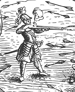
Samuel de Champlain was a French colonist, navigator, cartographer, draftsman, soldier, explorer, geographer, ethnologist, diplomat, and chronicler. He made between 21 and 29 trips across the Atlantic Ocean, and founded New France and Quebec City, on July 3, 1608. An important figure in Canadian history, Champlain created the first accurate coastal map during his explorations, and founded various colonial settlements.

Petite Riviere Bridge, Nova Scotia human settlement in Nova Scotia, Canada

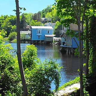
Petite Rivière Bridge is a rural community on Route 331 in Lunenburg County on the South Shore of Nova Scotia in Canada. It was formerly known simply as Petite Rivière.

See also

Related Research Articles

Mersey River (Nova Scotia) river in Canada

The Mersey River, formerly known as Rivière Rossignol by the Acadians, is a river in Nova Scotia, Canada. It is named after the River Mersey in Liverpool, England. The river proper flows from the eastern end of Eleven Mile Lake in Annapolis County southward to Kejimkujik Lake in Kejimkujik National Park, then through Lake Rossignol to empty into the Atlantic Ocean at the town of Liverpool, Nova Scotia. The true source of the river however is as far northwest as Sandy Bottom Lake or Tuskopeake Brook on the northern tributary.

Gaspereau, Nova Scotia human settlement in Nova Scotia, Canada

Gaspereau is a Canadian rural community located in Kings County, Nova Scotia.

Annapolis River Canadian river located in Nova Scotias Annapolis Valley

The Annapolis River is a Canadian river located in Nova Scotia's Annapolis Valley.

Musquodoboit River river in Canada

The Musquodoboit River is a Canadian river located in central Nova Scotia in the northeastern part of Halifax Regional Municipality. The river is approximately 97 kilometres (60 mi) in length with roughly 88 kilometres (55 mi) being traversable by paddle. It has a watershed area of 1,409 square kilometres (544 sq mi)

The Atlantic whitefish is a coregonine fish inhabiting some freshwater lakes within Nova Scotia, Canada. It is known to survive only in the Petite Rivière watershed as landlocked populations. Earlier it was also found in the Tusket and Annis rivers of Nova Scotia. Those populations were anadromous, migrating to the estuary to feed while breeding in freshwater.

Lighthouse Route

The Lighthouse Route is a scenic roadway in the Canadian province of Nova Scotia. It follows the province's South Shore for 339 km (211 mi) from Halifax to Yarmouth.

Westphal is an unincorporated suburban and rural community located in Dartmouth, Nova Scotia and outside of Dartmouth, Nova Scotia. Some of Westphal is considered part of Dartmouth, Nova Scotia and some of it is considered separate from Dartmouth, Nova Scotia. The area is bound by Port Wallace in the north, Waverley Road in the west, Lake Major Road in the east and Main Street in the south. The area also includes the watershed and water filtration plant for the Halifax Regional Water Commission that supplies drinking water for the residents of Dartmouth and surrounding communities east of Halifax Harbour. It is named after two Westphal brothers who became admirals in the British navy and who hailed from this part of Nova Scotia - George Augustus Westphal and his younger brother Philip. Their surname is of German origin.

LaHave River river in Canada

The LaHave River is a 97 km (60 mi) river in Nova Scotia, Canada, running from its source in Annapolis County to the Atlantic Ocean. Along its way, it splits the communities of LaHave and Riverport and runs along the Fairhaven Peninsula and bisects the town of Bridgewater flowing into the LaHave River estuary. Tides affect water levels for about 20 km up the river. There are a number of tourist attractions along the river, and it is also well-used for recreational sailing. As well as two bridges at Bridgewater, the river can be crossed by a cable ferry at the town of LaHave.

River John river in Canada

River John is a river in Nova Scotia. Draining the extreme western part of Pictou County, it flows into Amet Sound on the Northumberland Strait at River John, a village which takes its name from the river. The Mi’kmaq name is Kajeboogwek. An early name was Deception River. Its present name is believed to derive from Rivière Jaune, an Acadian name, though it may also derive from nearby Cap Jean. DesBarres called it River John in his Atlantic Neptune.

The Maccan River is a small tidal river contained completely within Cumberland County, Nova Scotia. The river terminates at the confluence of River Hebert at Amherst Point, and empties into the Cumberland Basin. The river's tidal bore may be viewed from the Tidal Wetlands Park in Maccan. According to estimates by the Province of Nova Scotia, there are 9,092 people resident within the Maccan/Kelly/Hebert watershed in 2011.

St. Croix River (Nova Scotia) river in Canada

The St. Croix River is a river in Nova Scotia entirely contained in Hants and Halifax Counties. Its headwaters are Panuke Lake. The river has been exploited for water power. There were water mills in the nineteenth century and in the 1930s three hydroelectric dams were built; they still operate.

Petit Rivière, Nova Scotia human settlement in Nova Scotia, Canada

Petite Riviere is a community in the Canadian province of Nova Scotia, located in the Lunenburg Municipal District in Lunenburg County. The proper spelling is "Petite" not "Petit" as shown incorrectly in the heading above. A more detailed article about the community of Petite Riviere can be found at Petite Riviere Bridge, Nova Scotia.

Conquerall Mills, Nova Scotia human settlement in Nova Scotia, Canada

Conquerall Mills is a community in the Canadian province of Nova Scotia, located in the Lunenburg Municipal District in Lunenburg County near Bridgewater and Conquerall Bank which are located on the shore of LaHave River. Conquerall Mills is dominated by Fancy Lake which is the source for the picturesque Petite Riverie. Fancy Lake is home to small mouth bass and the invasive species of chain pickerel. There are warnings against fishing the endangered Atlantic White fish which are rumored to exist in the Fancy Lake/Petite Riverie system. The community is 125 kilometers southwest of Halifax.

Black Lake (Nova Scotia) various lakes in Nova Scotia, Canada

There are various Black Lakes in Nova Scotia, Canada. They vary widely in size, depth and usability. Many counties, such as Cumberland, Halifax, Inverness, and Pictou Counties have more than one Black Lake so named, while other counties mentioned in this article have only one named Black Lake.

Bear River (Nova Scotia) minor river in western Nova Scotia, Canada

The Bear River is a minor river in western Nova Scotia, Canada. Flowing from south to north, it is 40 kilometres (25 mi) long from its headwaters to its discharge into the Annapolis Basin, some 6 kilometres (3.7 mi) east of Digby. The river is tidal for the last 9.7 kilometres (6.0 mi) of its length. The village of Bear River is situated near the head of the tide where shipbuilding took place in the nineteenth century.

Gaspereau River river in Canada

The Gaspereau River is a river in Kings County, Nova Scotia, Canada.

References

Coordinates: 44°13′51.6″N64°26′19.6″W / 44.231000°N 64.438778°W / 44.231000; -64.438778

Geographic coordinate system Coordinate system

A geographic coordinate system is a coordinate system that enables every location on Earth to be specified by a set of numbers, letters or symbols. The coordinates are often chosen such that one of the numbers represents a vertical position and two or three of the numbers represent a horizontal position; alternatively, a geographic position may be expressed in a combined three-dimensional Cartesian vector. A common choice of coordinates is latitude, longitude and elevation. To specify a location on a plane requires a map projection.