| Petunia Peak | |
|---|---|
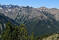
 North aspect | |
| Highest point | |
| Elevation | 6,953 ft (2,119 m) [1] |
| Prominence | 433 ft (132 m) [1] |
| Isolation | 0.62 mi (1.00 km) [2] |
| Coordinates | 47°50′04″N123°11′46″W / 47.834338°N 123.196105°W [3] |
| Geography | |
 Petunia Peak Location of Petunia Peak in Washington  Petunia Peak Petunia Peak (the United States) | |
| Country | United States |
| State | Washington |
| County | Jefferson |
| Protected area | Olympic National Park Buckhorn Wilderness |
| Parent range | Olympic Mountains |
| Topo map | USGS Mount Deception |
| Geology | |
| Rock age | Eocene |
| Climbing | |
| Easiest route | class 2 scrambling via Royal Lake [1] |
Petunia Peak is a 6,953-foot (2,119-metre) mountain summit located in Jefferson County of Washington state.