The Needles (Olympic Mountains)

Last updated
The Needles
The Needles from Mount Deception.jpg
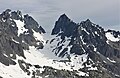
The Needles seen from Mt. Deception
Highest point
Peak Mount Johnson
Elevation 7,680 ft (2,340 m) [1]
Coordinates 47°49′57″N123°14′14″W / 47.8326263°N 123.2372141°W / 47.8326263; -123.2372141 [2]
Dimensions
Length2 mi (3.2 km)North-South
Width1 mi (1.6 km)East-West
Geography
USA Washington relief location map.jpg
Red triangle with thick white border.svg
Location in Washington
Usa edcp relief location map.png
Red triangle with thick white border.svg
The Needles (Olympic Mountains) (the United States)
Location Olympic National Park
Jefferson County, Washington
Country United States
State Washington
Range coordinates 47°53′21″N123°38′43″W / 47.8892984°N 123.6452825°W / 47.8892984; -123.6452825
Parent range Olympic Mountains
Topo map USGS Mount Deception
Geology
Age of rock Eocene

The Needles is a mountain ridge located within Olympic National Park in Jefferson County of Washington state. [2]

Contents

Description

The peaks and pinnacles of The Needles are part of the Olympic Mountains and are situated within the Daniel J. Evans Wilderness. They are bounded by Mount Deception to the south and Gray Wolf Ridge to the north. Precipitation runoff from the ridge drains east into Royal Creek, and west into Gray Wolf River, which are both within the Dungeness River drainage basin. Old-growth forests of Douglas fir, western hemlock, and western redcedar grow on the lower slopes surrounding the peaks.

History

This geographical feature's descriptive name has been officially adopted by the U.S. Board on Geographic Names. [2] The 1889–90 Seattle Press Expedition originally named it the "Holmes Range". [3] The expedition, led by James Halbold Christie and Charles Adams Barnes, had also christened Mount Deception as "Mount Holmes", in honor of John H. Holmes of the Boston Herald.

Climate

Based on the Köppen climate classification, the Needles range is located in the marine west coast climate zone of western North America. [4] Most weather fronts originate in the Pacific Ocean, and travel east toward the Olympic Peninsula. As fronts approach, they are forced upward by the peaks, causing moisture to drop in the form of rain or snowfall (Orographic lift). As a result, the range experiences high precipitation, especially during the winter months. During winter months, weather is usually cloudy, but due to high pressure systems over the Pacific Ocean that intensify during summer months, there is often little or no cloud cover during the summer. The months July through September offer the most favorable weather for visiting The Needles.

Summits

Principal summits of The Needles: [5]

NameElevation Prominence First ascent Reference
Mount Johnson 7,680 ft480 ft1940 [1]
Martin Peak 7,638 ft238 ft1940 [6]
Devil's Fang 7,600 ftunknown1972 [7]
Sweat Spire 7,560 ftunknown1962 [8]
Mount Clark 7,528 ft608 ft1940 [9]
Gasp Pinnacle 7,520 ft40 ft1958 [10]
The Incisor 7,440 ft40 ft1958 [11]
Mount Walkinshaw 7,378 ft378 ft1961 [12]
Adelaide Peak 7,300 ft120 ft1944 [13]
Sundial 7,200 ft80 ft1944 [14]
The Arrowhead 7,160 ftunknown1962 [15]

Geology

The Olympic Mountains are composed of obducted clastic wedge material and oceanic crust, primarily Eocene sandstone, turbidite, and basaltic oceanic crust. [16] The mountains were sculpted during the Pleistocene era by erosion and glaciers advancing and retreating multiple times.

See also

Related Research Articles

<span class="mw-page-title-main">Mount Deception (Washington)</span> Mountain in Washington (state), United States

Mount Deception is a peak in the Olympic Mountains of Cascadia. It is in Olympic National Park on the Olympic Peninsula in the U.S. state of Washington.

<span class="mw-page-title-main">Gray Wolf Ridge</span> Mountain in United States of America

Gray Wolf Ridge is a spur of the northeastern Olympic Mountains in Washington's Olympic Peninsula. Arcing northeast from the Mount Deception - Needles - Mount Clark - Mount Walkinshaw massif, Gray Wolf Ridge is covered by alpine and subalpine forests up to the timberline, leaving the upper elevations of the ridge's six rocky peaks vegetated only by fragile alpine meadows. The ridge and its component mountains are markedly steep, as is its primary access route, the Maynard Burn Trail (#816) of Olympic National Forest. The higher, western segment of Gray Wolf Ridge lies within the boundary of Olympic National Park.

<span class="mw-page-title-main">Mount Mystery</span> Mountain in Washington (state), United States

Mount Mystery is a prominent 7,639-foot (2,328-metre) mountain summit located in the Olympic Mountains in Jefferson County of Washington state. It is located within Olympic National Park on the Olympic Peninsula. Mount Mystery is the sixth-highest peak of the Olympic Mountains, after Mount Olympus, Mount Deception, Mount Constance, Mount Johnson, and Inner Constance. Its nearest higher neighbor is Mount Deception, 1.32 mi (2.12 km) to the north-northwest. Little Mystery (6941 ft) is a subsidiary summit south of Mount Mystery.

<span class="mw-page-title-main">Mount Johnson (Washington)</span> Mountain in Washington (state), United States

Mount Johnson is a summit in the Olympic Mountains and is located in Jefferson County of Washington state. It is situated within Olympic National Park, and is set within the Daniel J. Evans Wilderness. At 7,680 feet (2,340 m) high, Mount Johnson is the fourth-highest peak of the Olympic Mountains, after Mount Olympus, Mount Deception, and Mount Constance. It is the highest peak in The Needles range which is a subset of the Olympic range. The nearest higher neighbor is Mount Deception, 1.34 mi (2.16 km) to the south. Mount Johnson is set in the eastern portion of the Olympic Mountains within the drainage basin of the Dungeness River. This location puts it in the rain shadow of the Olympic Range, resulting in less precipitation than Mount Olympus and the western Olympics receive.

<span class="mw-page-title-main">Inner Constance</span> Mountain in Washington (state), United States

Inner Constance is a summit of the Olympic Mountains and is located in Jefferson County of Washington state. It's located near the eastern edge of Olympic National Park on the Olympic Peninsula. At 7,667 feet (2,337 m) high, Inner Constance is the fifth highest peak of the Olympic Mountains, after Mount Olympus, Mount Deception, Mount Constance, and Mount Johnson. Its nearest higher neighbor is Mount Constance, 0.9 mi (1.4 km) to the east. Within this nearly mile-wide separation resides a deep glacially carved canyon called "Avalanche Canyon". Precipitation runoff on the north side of the peak drains into tributaries of the Dungeness River, whereas the south side drains into tributaries of the Dosewallips River.

<span class="mw-page-title-main">Gilhooley Tower</span>

Gilhooley Tower is a basalt spire in the Olympic Mountains and is located in Jefferson County of Washington state. It is situated in Olympic National Park on the Olympic Peninsula. Its nearest higher peak is Mount Deception at 0.13 mi (0.21 km) to the southeast. Precipitation runoff drains into tributaries of the Dungeness River and Dosewallips River.

<span class="mw-page-title-main">Mount Clark (Washington)</span> Mountain in Washington (state), United States

Mount Clark is a 7,528-foot (2,295-metre) mountain summit located within Olympic National Park in Jefferson County of Washington state. Its nearest higher peak is Sweat Spire (7,580 ft) on Mount Johnson, 0.26 mi (0.42 km) to the southwest, and Mount Walkinshaw is set 0.9 mi (1.4 km) to the north. It is the second highest peak in The Needles range, which is a subrange of the Olympic Mountains, and seventh highest in the Olympic Mountains. The climbing routes on Mt. Clark start at Class 3 scrambling and range up to Class 5.5 via the central South Face. Precipitation runoff from the mountain drains into tributaries of the Dungeness River.

<span class="mw-page-title-main">Mount Fricaba</span> Mountain in Washington (state), United States

Mount Fricaba is a 7,139-foot-elevation (2,176 m) double summit mountain located in the Olympic Mountains, in Jefferson County of Washington state. It is situated on the shared border of Olympic National Park with Buckhorn Wilderness, and is the highest point in that wilderness, as well as the Olympic National Forest. Its nearest higher peak is Hal Foss Peak, 0.74 miles (1.19 km) to the southwest. Precipitation runoff from the peak drains east into headwaters of the Dungeness River, or west into Deception Creek which is a tributary of the Dosewallips River. The mountain's name was officially adopted in 1961 by the United States Board on Geographic Names based on usage by The Mountaineers since 1907, and inclusion in Fred Beckey's "Climber's Guide to the Cascade and Olympic Mountains of Washington" published in 1949. The first ascent of the mountain was made in 1957 by Don Bechlem and Jack Newman.

<span class="mw-page-title-main">Mount Walkinshaw</span> Mountain in Washington, USA

Mount Walkinshaw is a 7,378 feet (2,249 m) mountain summit located in the Olympic Mountains, in Jefferson County of Washington state. It is situated within Olympic National Park, and is the northernmost peak in The Needles range, which is a subset of the Olympic range. Its nearest higher peak is Mount Clark, 0.9 mi (1.4 km) to the south, and Gray Wolf Ridge arcs to the northeast. Mount Walkinshaw is set in the eastern portion of the Olympic Mountains within the drainage basin of the Dungeness River. This position puts it in the rain shadow of the Olympic Range, resulting in less precipitation than Mount Olympus and the western Olympics receive.  

<span class="mw-page-title-main">Stephen Peak</span> Mountain in Washington (state), United States

Stephen Peak is a 6,418-foot (1,956-metre) mountain summit located within Olympic National Park in Jefferson County of Washington state. Stephen Peak is the fifth-highest peak in the Bailey Range, which is a subrange of the Olympic Mountains. In clear weather, the mountain can be seen from the visitor center at Hurricane Ridge, appearing to the left of Mount Olympus. Mount Ferry is set 2.26 mi (3.64 km) to the southeast, and Stephen's nearest higher neighbor is Ruth Peak which is an outlier of Mount Carrie, 2.1 mi (3.4 km) to the northwest. Precipitation runoff from the mountain drains into tributaries of the Elwha River and Hoh River. The first ascent of this peak was made in 1961 by Kent Heathershaw, Doug Waali, and Robert Wood.

<span class="mw-page-title-main">Mount Fitzhenry</span> Mountain in Washington (state), United States

Mount Fitzhenry is a 6,050-foot (1,840-metre) mountain summit located within Olympic National Park in Clallam County of Washington state. Mt. Fitzhenry is in the Bailey Range, which is a subrange of the Olympic Mountains. The mountain can be seen from the visitor center at Hurricane Ridge in clear weather. Its nearest higher neighbor is Mount Fairchild, 1.57 mi (2.53 km) to the south. Precipitation runoff from the mountain drains into tributaries of the Elwha River. Mount Fitzhenry is situated at the head of Fitzhenry Creek, and both are named for Edward Allen Fitzhenry (1868–1937), Clallam County surveyor from 1892-1900. President Woodrow Wilson appointed Fitzhenry as Washington Surveyor General in 1913, and he later served as Deputy State Land Commissioner.

<span class="mw-page-title-main">Mount Pulitzer (Washington)</span> Mountain in Washington (state), United States

Mount Pulitzer, also known as Snagtooth, is a 6,283-foot (1,915-metre) mountain summit located within Olympic National Park in Jefferson County of Washington state. Mount Pulitzer is the sixth-highest peak in the Bailey Range, which is a subrange of the Olympic Mountains. Its nearest neighbor is Mount Ferry, 0.58 mi (0.93 km) to the northeast, and its nearest higher neighbor is Stephen Peak, 2.58 mi (4.15 km) to the north. Mount Olympus is set 6.8 mi (10.9 km) to the southwest. In clear weather, the mountain can be seen from the visitor center at Hurricane Ridge. Precipitation runoff from the mountain drains into tributaries of the Elwha and Hoh Rivers. The first ascent of the summit was made in 1961 by Doug Waali, Bob Wood, and Kent Heathershaw via the east ridge.

<span class="mw-page-title-main">Ruth Peak</span> Mountain in Washington (state), United States

Ruth Peak is a 6,850+ ft glaciated mountain summit located within Olympic National Park in Clallam County of Washington state. Ruth Peak is the third-highest peak in the Bailey Range, which is a subrange of the Olympic Mountains. Its nearest higher neighbor is Mount Carrie, 0.91 mi (1.46 km) to the northwest, and Mount Fairchild is set 0.92 mi (1.48 km) to the north. In clear weather, the mountain can be seen from the visitor center at Hurricane Ridge. Precipitation runoff from the mountain drains into tributaries of the Hoh and Elwha Rivers. The first ascent of this peak was made in 1961 by Bert Brown, Roy Etten, and Victor Nelson.

<span class="mw-page-title-main">Martin Peak (Olympic Mountains)</span> Mountain in Washington (state), United States

Martin Peak is a mountain summit in the Olympic Mountains and is located in Jefferson County of Washington state. It is located within Olympic National Park. At 7,638 feet (2,328 m) high, Martin Peak is the seventh-highest peak of the Olympic Mountains, and the second-highest peak in The Needles range, which is a subset of the Olympic range. Its nearest higher neighbor is Mount Johnson, 0.53 mi (0.85 km) to the north-northwest. Precipitation runoff from this peak drains west into headwaters of Gray Wolf River, or east into Royal Creek, both of which are part of the Dungeness River drainage basin. Martin Peak was given its name based on the first ascent in 1940 by George W. Martin (1901–1970), and Elvin Johnson.

<span class="mw-page-title-main">Sundial (Olympic Mountains)</span> Mountain in Washington (state), United States

Sundial is a 7,200+ ft mountain summit located within Olympic National Park, in Jefferson County of Washington state. Sundial is part of The Needles range, which is a subrange of the Olympic Mountains. Its nearest higher neighbor is Mount Clark, 0.27 mi (0.43 km) to the northwest, and Mount Johnson is set 0.45 mi (0.72 km) to the west. The climbing routes on Sundial start at class 3 scrambling via the East Face, and range up to class 5 via the South Side Face. The first ascent of the mountain was made in 1944 by Adel and William Degenhardt. The mountain is so named because the time of day can be approximated as an observer in Royal Basin watches the sun's rays make their way down the east face of this mountain in the morning. Precipitation runoff from the mountain drains into Royal Creek which is a tributary of the Dungeness River.

<span class="mw-page-title-main">Mount Wilder</span> Mountain in Washington (state), United States

Mount Wilder is a 5,939-foot (1,810-metre) mountain summit located near the head of the Elwha Valley, deep within Olympic National Park in Jefferson County of Washington state. Part of the Olympic Mountains, Wilder represents the southernmost peak of the Bailey Range. It is situated 8.7 miles east-southeast of Mount Olympus, and is set within the Daniel J. Evans Wilderness. Neighbors include line parent Mount Dana, 2.3 miles (3.7 km) to the northeast, and Mount Seattle rises 3.7 miles to the southwest. The headwaters of the Goldie River form on the south slope of the mountain, and precipitation runoff from the mountain drains into Goldie River and other tributaries of the Elwha River. Topographic relief is significant as the south aspect of the peak rises nearly 3,800 feet (1,160 m) in less than two miles.

The Bailey Range is a mountain range located within Olympic National Park in Washington state.

<span class="mw-page-title-main">Ludden Peak</span> Mountain in Washington (state), United States

Ludden Peak is a 5,854-foot (1,784-metre) mountain summit located within Olympic National Park in Jefferson County of Washington state. Ludden Peak is part of the Bailey Range, which is a subrange of the Olympic Mountains, and is set within the Daniel J. Evans Wilderness. In clear weather, the mountain can be seen from the park's visitor center on Hurricane Ridge. The nearest higher neighbor is Mount Scott, one mile to the south-southeast, line parent Mount Ferry rises 1.6 mi (2.6 km) to the southwest, Dodger Point is 1.9 mi (3.1 km) to the northeast, and Stephen Peak is set 2.7 mi (4.3 km) to the northwest. Precipitation runoff from the mountain drains into tributaries of the Elwha River.

<span class="mw-page-title-main">Adelaide Peak (Washington)</span> Mountain in Washington, USA

Adelaide Peak is a 7,300-foot-elevation mountain summit located in the Olympic Mountains, in Jefferson County of Washington state. It is situated within Olympic National Park, and is set within the Daniel J. Evans Wilderness. It is part of The Needles range, which is a subset of the Olympic range. The nearest higher peak is Mount Clark, 0.3 mi (0.48 km) to the south, and Mount Walkinshaw rises 0.66 mi (1.06 km) to the north-northwest. The peak is in the rain shadow of the Olympic Range, resulting in less precipitation than Mount Olympus and the western Olympics receive. Precipitation runoff from the mountain drains east into Royal Creek, and west into Gray Wolf River, which are both within the drainage basin of the Dungeness River. Topographic relief is significant as the east aspect rises 2,600 feet (793 m) above Royal Creek in less than one mile.  

<span class="mw-page-title-main">Sweat Spire</span> Mountain in Washington (state), United States

Sweat Spire is a 7,580-foot-elevation (2,310 meter) summit located in the Olympic Mountains, in Jefferson County of Washington state. It is situated within Olympic National Park, and is set within the Daniel J. Evans Wilderness. It is part of The Needles range, which is a subset of the Olympic range. The nearest higher peak is Mount Johnson, 0.06 mi (0.097 km) to the southwest, and Gasp Pinnacle (7,520 ft) is to the immediate north. The spire is in the rain shadow of the Olympic Range, resulting in less precipitation than Mount Olympus and the western Olympics receive. Precipitation runoff from the mountain drains east into Royal Creek, and west into Gray Wolf River, which are both within the drainage basin of the Dungeness River. Topographic relief is significant as the east aspect rises over 2,400 feet (730 m) above Royal Basin in approximately one mile. The first ascent of the 200-foot-tall spire was made in 1962 by Hilton Keith, Joel Merkel, Joe Munson, and Jim Parolini. This landform's name has not been officially adopted by the U.S. Board on Geographic Names, so the feature is not labeled on USGS maps.

References

  1. 1 2 "Mount Johnson, Washington". Peakbagger.com. Retrieved 2022-02-14.
  2. 1 2 3 "The Needles". Geographic Names Information System . United States Geological Survey, United States Department of the Interior . Retrieved 2022-02-14.
  3. Parratt, Smitty (1984). Gods and Goblins: A Field Guide to Place Names of Olympic National Park (1st ed.).
  4. Peel, M. C.; Finlayson, B. L.; McMahon, T. A. (2007). "Updated world map of the Köppen−Geiger climate classification". Hydrol. Earth Syst. Sci. 11 (5): 1633–1644. Bibcode:2007HESS...11.1633P. doi: 10.5194/hess-11-1633-2007 . ISSN   1027-5606.
  5. "The Needles Area – Climbers Guide to the Olympic Mountains". climbersguideolympics.com. Archived from the original on 2017-03-21. Retrieved 2022-02-14.
  6. "Martin Peak". Peakbagger.com. Retrieved 2022-02-14.
  7. "Devil's Fang – Climbers Guide to the Olympic Mountains". climbersguideolympics.com. Archived from the original on 2010-11-27. Retrieved 2022-02-14.
  8. "Sweat Spire, Washington". Peakbagger.com. Retrieved 2022-02-14.
  9. "Mount Clark, Washington". Peakbagger.com. Retrieved 2022-02-14.
  10. "Gasp Pinnacle, Washington". Peakbagger.com. Retrieved 2022-02-14.
  11. "The Incisor, Washington". Peakbagger.com. Retrieved 2022-02-14.
  12. "Mount Walkinshaw, Washington". Peakbagger.com. Retrieved 2022-02-14.
  13. "Adelaide Peak, Washington". Peakbagger.com. Retrieved 2022-02-14.
  14. "Sundial, Washington". Peakbagger.com. Retrieved 2022-02-14.
  15. "The Arrowhead, Washington". Peakbagger.com. Retrieved 2022-02-14.
  16. Alt, D.D.; Hyndman, D.W. (1984). Roadside Geology of Washington. pp. 249–259. ISBN   0-87842-160-2.

Commons-logo.svg Media related to The Needles (Olympic Mountains) at Wikimedia Commons