
San Juan County is a county in the southeastern portion of the U.S. state of Utah. As of the 2010 United States Census, the population was 14,746. Its county seat is Monticello, while its most populous city is Blanding. The county was named by the Utah State Legislature for the San Juan River, itself named by Spanish explorers.

Window Rock is a small city that serves as the seat of government and capital of the Navajo Nation, the largest territory of a sovereign Native American nation in North America. It lies within the boundaries of the St. Michaels Chapter, adjacent to the Arizona and New Mexico state line. Window Rock hosts the Navajo Nation governmental campus which contains the Navajo Nation Council, Navajo Nation Supreme Court, the offices of the Navajo Nation President and Vice President, and many Navajo government buildings.

The Navajo Nation is a Native American territory covering about 17,544,500 acres, occupying portions of northeastern Arizona, southeastern Utah, and northwestern New Mexico in the United States. This is the largest land area retained by a Native American tribe, with a population of roughly 350,000 as of 2016.

The Four Corners is a region of the United States consisting of the southwestern corner of Colorado, southeastern corner of Utah, northeastern corner of Arizona, and northwestern corner of New Mexico. The Four Corners area is named after the quadripoint at the intersection of approximately 37° north latitude with 109° 03' west longitude, where the boundaries of the four states meet, and are marked by the Four Corners Monument. It is the only location in the United States where four states meet. Most of the Four Corners region belongs to semi-autonomous Native American nations, the largest of which is the Navajo Nation, followed by Hopi, Ute, and Zuni tribal reserves and nations. The Four Corners region is part of a larger region known as the Colorado Plateau and is mostly rural, rugged, and arid. In addition to the monument, commonly visited areas within Four Corners include Monument Valley, Mesa Verde National Park, Chaco Canyon, Canyons of the Ancients National Monument and Canyon de Chelly National Monument. The most populous city in the Four Corners region is Farmington, New Mexico, followed by Durango, Colorado.
U.S. Route 491 (US 491) is a north–south U.S. Highway serving the Four Corners region of the United States. One of the newest designations in the U.S. Highway System, it was created in 2003 as a renumbering of U.S. Route 666 (US 666). With the 666 designation, this road was nicknamed the "Devil's Highway" because of the significance of number 666 to many Christian denominations, which is believed by some that 666 is the Number of the Beast. This Satanic connotation, combined with a high fatality rate along the New Mexico portion, convinced some people the highway was cursed. The problem was compounded by persistent sign theft. These factors led to two efforts to renumber the highway, first by officials in Arizona, later in New Mexico. There have been safety improvement projects in recent years, and fatality rates have subsequently decreased.

The San Juan River is a major tributary of the Colorado River in the southwestern United States, providing the chief drainage for the Four Corners region of Colorado, New Mexico, Utah and Arizona. Originating as snowmelt in the San Juan Mountains of Colorado, it flows 383 miles (616 km) through the deserts of northern New Mexico and southeastern Utah to join the Colorado River at Glen Canyon. The river drains a high, arid region of the Colorado Plateau and along its length it is often the only significant source of fresh water for many miles. The San Juan is also one of the muddiest rivers in North America, carrying an average of 25 million US tons of silt and sediment each year.

The term Navajo Wars covers at least three distinct periods of conflict in the American West: the Navajo against the Spanish ; the Navajo against the Mexican government ; and the Navajo against the United States. These conflicts ranged from small-scale raiding to large expeditions mounted by governments into territory controlled by the Navajo. The Navajo Wars also encompass the widespread raiding that took place throughout the period; the Navajo raided other tribes and nearby settlements, who in return raided into Navajo territory, creating a cycle of raiding that perpetuated the conflict.
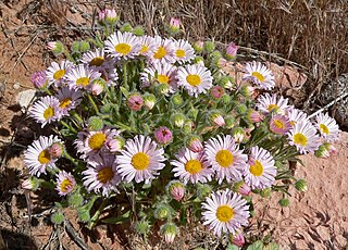
Erigeron concinnus is a perennial flowering plant in the daisy family.

Navajo Mountain is a peak in San Juan County, Utah, with its southern flank extending into Coconino County, Arizona. It holds an important place in the traditions of three local Native American tribes. The summit is the highest area on the Navajo Nation.

Kenneth Maryboy is an American politician for San Juan County, Utah, and was Navajo Nation Council Delegate. Kenneth is a former San Juan County Commissioner. Maryboy was the third Democrat in a row to have been elected to the Commissioner District 3 position since its inception in 1984 that divided the county into three districts. Kenneth was replaced on the commission in 2015 by Rebecca M. Benally

Cirsium arizonicum, the Arizona thistle, is a North American species of thistle in the sunflower family, native to the southwestern United States and northwestern Mexico. It has been found in Arizona, southeastern California, New Mexico, Nevada, Colorado, Utah, Sonora, and northwestern Chihuahua.
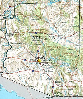
Arizona is a landlocked state situated in the southwestern region of the United States of America. It has a vast and diverse geography famous for its deep canyons, high- and low-elevation deserts, numerous natural rock formations, and volcanic mountain ranges. Arizona shares land borders with Utah to the north, the Mexican state of Sonora to the south, New Mexico to the east, and Nevada to the northwest, as well as water borders with California and the Mexican state of Baja California to the southwest along the Colorado River. Arizona is also one of the Four Corners states and is diagonally adjacent to Colorado.

Physaria is a genus of flowering plants in the mustard family. Many species are known generally as twinpods, bladderpods, or lesquerella. They are native to the Americas, with many species endemic to western North America. They are densely hairy annual and perennial herbs often growing prostrate or decumbent, along the ground in patches or clumps. They bear inflorescences of bright yellow flowers. The fruit is often notched deeply, dividing into twin sections, giving the genus its common name.
Proatriplex is a monotypic plant genus in the subfamily Chenopodioideae of the Amaranthaceae family, with the only species Proatriplex pleiantha. It is known by the common names Four-corners orach and Mancos shadscale. It occurs in the Navajo Basin of Arizona, Colorado, New Mexico, and Utah.

Physaria parvula is a species of flowering plant in the mustard family known by the common name pygmy bladderpod. It is native to the western United States, where it can be found in Colorado, Utah, and Wyoming.

Physaria tumulosa is a rare species of flowering plant in the mustard family known by the common name Kodachrome bladderpod. It is endemic to Utah in the United States, where it is known only from Kane County. There is only one known population of this plant made up of scattered occurrences totalling about 20,000 individuals, all within the Kodachrome Basin. The plant is threatened by the loss and degradation of its habitat. It is federally listed as an endangered species. It was previously treated as a subspecies of Physaria hitchcockii.
Physaria lepidota, common name Kane County twinpod, is a plant species endemic to Utah. It is known only from Kane, Washington, and Garfield Counties in the southern part of the state. It grows on rocky slopes and outcrops, and sometimes in disturbed areas.
Chrysothamnus vaseyi called Vasey's rabbitbrush, is a North American species of flowering plants in the aster tribe within the sunflower family. It has been found in Utah, Colorado, northern New Mexico, southern Wyoming, northern Arizona and eastern Nevada.
Physaria gordonii, commonly known as Gordon's bladderpod is a species of mustard plant distributed throughout the Southwestern United States and Northern Mexico. It is a winter annual wildflower, maturing between April and June. The plant normally grows in sandy or gravel deserts. The plant has low-growing stems, with long, lanceolate leaves measuring about 4 in (10 cm). The plants flowers are in a loose, raceme cluster, and are radially symmetrical. The plant is very similar to P. fendleri.
Physaria floribundaRydb., common name pointtip twinpod, is a member of the mustard family (Brassicaceae). It is an herbaceous perennial occurring in the United States states of Colorado, Utah, and Arizona.


