Pierpont, Missouri

Last updated
Location of Pierpont, Missouri MOMap-doton-Pierpont.png
Location of Pierpont, Missouri
Pierpont, Missouri
Village of Pierpont
CountryUnited States
State Missouri
County Boone
Area
[1]
  Total0.23 sq mi (0.59 km2)
  Land0.23 sq mi (0.59 km2)
  Water0.00 sq mi (0.00 km2)
Elevation
[2]
768 ft (234 m)
Population
 (2020)
  Total64
  Density280.70/sq mi (108.30/km2)
FIPS code 29-57512
GNIS feature ID2399669 [2]

Pierpont is a village in Boone County, Missouri, United States. [3] It is part of the Columbia, Missouri Metropolitan Statistical Area. The population was 64 at the 2020 census. The village, located south of Rock Bridge Memorial State Park at Route N and Highway 163, [4] was incorporated in 2004 to avoid annexation by the city of Columbia. It is now an independent village with its own governing board of trustees. [5]

Contents

Geography

According to the United States Census Bureau, the village has a total area of 0.25 square miles (0.65 km2), all land. [6]

Demographics

Historical population
CensusPop.Note
2010 76
2020 64−15.8%
U.S. Decennial Census [7]

2010 census

As of the census [8] of 2010, there were 76 people, 32 households, and 25 families residing in the village. The population density was 304.0 inhabitants per square mile (117.4/km2). There were 32 housing units at an average density of 128.0 per square mile (49.4/km2). The racial makeup of the village was 97.4% White, 1.3% African American, and 1.3% from two or more races.

There were 32 households, of which 25.0% had children under the age of 18 living with them, 75.0% were married couples living together, 3.1% had a male householder with no wife present, and 21.9% were non-families. 18.8% of all households were made up of individuals, and 9.4% had someone living alone who was 65 years of age or older. The average household size was 2.38 and the average family size was 2.72.

The median age in the village was 54.3 years. 19.7% of residents were under the age of 18; 4% were between the ages of 18 and 24; 14.4% were from 25 to 44; 35.5% were from 45 to 64; and 26.3% were 65 years of age or older. The gender makeup of the village was 52.6% male and 47.4% female.

Education

Its school district is Columbia 93 School District. [9]

Related Research Articles

<span class="mw-page-title-main">Cooper County, Missouri</span> County in Missouri, United States

Cooper County is located in the central portion of the U.S. state of Missouri. As of the 2020 United States census, the population was 17,103. Its county seat is Boonville. The county was organized December 17, 1818 and named for Sarshell Cooper, a frontier settler who was killed by Native Americans near Arrow Rock in 1814. It is a part of the Columbia, Missouri metropolitan area.

<span class="mw-page-title-main">Boone County, Missouri</span> County in Missouri, United States

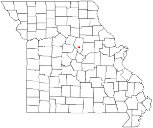
Boone County is located in the U.S. state of Missouri. Centrally located in Mid-Missouri, its county seat is Columbia, Missouri's fourth-largest city and location of the University of Missouri. As of the 2020 census, the population was 183,610, making it the state's eighth-most populous county. The county was organized November 16, 1820 and named for the then recently deceased Daniel Boone, whose kin largely populated the Boonslick area, having arrived in the 1810s on the Boone's Lick Road. Boone County comprises the Columbia Metropolitan Area. The towns of Ashland and Centralia are the second and third most populous towns in the county.

<span class="mw-page-title-main">Foster, Missouri</span> Village in Missouri, United States

Foster is a village in Bates County, Missouri, and part of the Kansas City metropolitan area within the United States. The population was 76 at the 2020 census.

<span class="mw-page-title-main">Ashland, Missouri</span> City in Missouri, United States

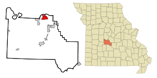
Ashland is a city in Boone County, Missouri, United States. Ashland is part of the Columbia, Missouri Metropolitan Statistical Area. The population was 4,747 at the 2020 census.

<span class="mw-page-title-main">Harrisburg, Missouri</span> Village in Missouri, United States

Harrisburg is a village in western Boone County, Missouri, United States. It is part of the Columbia, Missouri Metropolitan Statistical Area. The population was 266 at the 2010 census.

<span class="mw-page-title-main">Hartsburg, Missouri</span> Village in Missouri, United States

Hartsburg is a village in southern Boone County, Missouri, United States. It is part of the Columbia, Missouri Metropolitan Statistical Area. The population was 133 per the 2020 census.

<span class="mw-page-title-main">McBaine, Missouri</span> Town in Missouri, United States

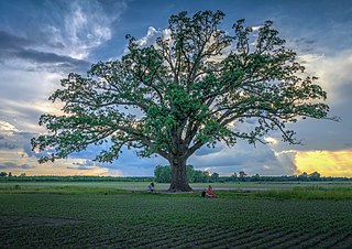
McBaine is a village in Boone County, Missouri, United States. It is part of the Columbia, Missouri Metropolitan Statistical Area. The population was 10 at the 2010 census. McBaine is located just north of Eagle Bluffs Conservation Area and within sight of The Big Tree.

<span class="mw-page-title-main">Village of Four Seasons, Missouri</span> Village in Missouri, United States

Village of Four Seasons is a village in Camden County, Missouri, United States. The population was 2,217 at the 2010 census. The village is situated on the shores of Lake of the Ozarks and is a popular tourist destination along with the other communities in the area.

<span class="mw-page-title-main">Wooldridge, Missouri</span> Village in Missouri, United States

Wooldridge is a village in northeastern Cooper County, Missouri, United States. The population was 61 at the 2010 census. On October 22, 2022, a large fire destroyed 23 buildings, about half the town.

<span class="mw-page-title-main">Franklin, Missouri</span> City in Missouri, United States

Franklin is a city in Howard County, Missouri, United States. It is located along the Missouri River in the central part of the state. Located in a rural area, the city had a population of 70 at the 2020 census. It is part of the Columbia, Missouri Metropolitan Statistical Area.

<span class="mw-page-title-main">Evergreen, Missouri</span> Village in Missouri, United States

Evergreen is a village in Laclede County, Missouri, United States. The population was 28 at the 2010 census. It was named Twin Bridges at the 2000 census.

<span class="mw-page-title-main">Tuscumbia, Missouri</span> Town in Missouri, United States

Tuscumbia is a village in and the county seat of Miller County, Missouri, United States. The population was 203 at the 2010 census, at which time it was a town.

<span class="mw-page-title-main">Eolia, Missouri</span> Village in Missouri, United States

Eolia is a village in Pike County, Missouri, United States. The population was 522 at the 2010 census.

<span class="mw-page-title-main">Blodgett, Missouri</span> Village in Missouri, United States

Blodgett is a village in Scott County, Missouri, United States. The population was 213 at the 2010 census.

<span class="mw-page-title-main">Bellerive Acres, Missouri</span> City in Missouri, United States

Bellerive Acres is a northern suburban city in St. Louis County, Missouri, United States. The population was 188 at the 2010 census. In April, 2015, the residents voted to change the village of Bellerive to a fourth class city named Bellerive Acres.

<span class="mw-page-title-main">Mackenzie, Missouri</span> Village in Missouri, United States

Mackenzie is an unincorporated community in St. Louis County, Missouri, United States. The population was 134 at the 2010 census.

<span class="mw-page-title-main">Norwood Court, Missouri</span> Village in Missouri, United States

Norwood Court is a village in St. Louis County, Missouri, United States. The population was 959 at the 2010 census.

<span class="mw-page-title-main">Baldwin Park, Missouri</span> Village in Missouri, United States

Baldwin Park is a village in Cass County, Missouri, United States. The population was 92 at the 2010 census. It is part of the Kansas City metropolitan area.

<span class="mw-page-title-main">Ionia, Missouri</span> Village in Missouri, United States

Ionia is a village in northern Benton and southern Pettis counties in the U.S. state of Missouri. The population was 88 at the 2010 census.

Huntsdale is a village in Boone County, Missouri, United States. It is part of the Columbia, Missouri Metropolitan Statistical Area. The population was 31 at the 2010 census. The village was founded on August 1, 1892 and named after William Burch Hunt, a landowner. Huntsdale was first incorporated in 1906, but that status eventually fell into neglect and the last village council election took place in 1929. Due mainly to an influx of residential development in the area, Huntsdale was reincorporated in February 2003 and its first elections were held two months later. A center of activity in Huntsdale was Katfish Katy's, a small trail-side, seasonal restaurant along the Katy Trail State Park, until its closure in 2020. Katy's Little Lodge, formerly a bed and breakfast, was another notable business in the village.

References

  1. "ArcGIS REST Services Directory". United States Census Bureau. Retrieved August 28, 2022.
  2. 1 2 U.S. Geological Survey Geographic Names Information System: Pierpont, Missouri
  3. U.S. Geological Survey Geographic Names Information System: Pierpont, Missouri
  4. Ashland, Missouri, 7.5 Minute Topographic Quadrangle, USGS, 1969 (1982 rev.)
  5. "Tinier towns hold onto identities as county develops". Columbia Daily Tribune. 2007-06-17. Archived from the original on 2007-09-27. Retrieved 2007-08-06.
  6. "US Gazetteer files 2010". United States Census Bureau. Archived from the original on 2012-01-25. Retrieved 2012-07-08.
  7. "Census of Population and Housing". Census.gov. Retrieved June 4, 2015.
  8. "U.S. Census website". United States Census Bureau . Retrieved 2012-07-08.
  9. "2020 CENSUS - SCHOOL DISTRICT REFERENCE MAP: Boone County, MO" (PDF). U.S. Census Bureau . Retrieved 2023-07-19.

38°51′44″N92°18′54″W / 38.86222°N 92.31500°W / 38.86222; -92.31500