Columbia is a city in the U.S. state of Missouri. It is the county seat of Boone County and home to the University of Missouri. Founded in 1821, it is the principal city of the five-county Columbia metropolitan area. It is Missouri's fourth most-populous and fastest growing city, with an estimated 128,555 residents in 2022.

Boone County is located in the U.S. state of Missouri. Centrally located in Mid-Missouri, its county seat is Columbia, Missouri's fourth-largest city and location of the University of Missouri. As of the 2020 census, the population was 183,610, making it the state's eighth-most populous county. The county was organized November 16, 1820 and named for the then recently deceased Daniel Boone, whose kin largely populated the Boonslick area, having arrived in the 1810s on the Boone's Lick Road. Boone County comprises the Columbia Metropolitan Area. The towns of Ashland and Centralia are the second and third most populous towns in the county.

Monroe County is a county located in the U.S. state of Illinois. According to the 2020 census, it had a population of 34,962. Its county seat and largest city is Waterloo.
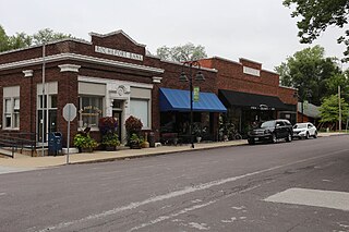
Rocheport is a city in Boone County, Missouri, United States. It is part of the Columbia, Missouri Metropolitan Statistical Area. The population was 239 at the 2010 census. Rocheport includes the Rocheport Historic District, an area with buildings dating from 1830 and which is listed on the National Register of Historic Places.

The Katy Trail State Park is a state park in the U.S. state of Missouri that contains the Katy Trail, the country's longest continuous recreational rail trail. It runs 240 miles (390 km), largely along the northern bank of the Missouri River, in the right-of-way of the former Missouri–Kansas–Texas Railroad. Open year-round from sunrise to sunset, it serves hikers, joggers, and cyclists. Its hard, flat surface is of "limestone pug".

Rocheport, also known as Rocheport Historic District, is a historic district in Rocheport, Missouri. It dates from 1830.

Route 240 is a highway in the central part of Missouri. Its eastern terminus is at U.S. Route 40 about two miles (3 km) west of Columbia; its western terminus is at U.S. Route 65 in Marshall. Spur Route 240 connects the road with Rocheport.
The Daniel Boone Bridge is the name for two bridges carrying Interstate 64, U.S. Route 40 and U.S. Route 61 across the Missouri River between St. Louis County and St. Charles County, Missouri. The older bridge, which carries westbound traffic, is a continuous truss bridge, while the newer bridge, which carries eastbound traffic, is a deck girder bridge.
The Centralia Massacre was an incident during the American Civil War in which 24 unarmed U.S. Army soldiers were captured and executed in Centralia, Missouri on September 27, 1864, by a band led by the pro-Confederate guerrilla leader William T. Anderson. Future outlaw Jesse James was among the guerrillas.
The Columbia metropolitan area is the region centered around the City of Columbia in the U.S. state of Missouri. Located in Mid-Missouri, it consists of five counties: Boone, Audrain, Randolph, Cooper, and Howard. The population was estimated at 256,640 in 2017, making it the 4th largest metropolitan area in Missouri. Columbia is home to the University of Missouri, and is Missouri's fourth most-populous and fastest growing city, with an estimated 121,717 residents as of 2017. Other significant cities in the area include Moberly, Mexico, Boonville, Vandalia, Centralia, and Fayette.

Round Prairie Township is one of eighteen townships in Callaway County, Missouri, USA. As of the 2010 census, its population was 1038.

A total of eight special routes of U.S. Route 65 exist, divided between the U.S. states of Arkansas and Missouri. Currently, they are all business loops, although a spur route in Pine Bluff, Arkansas and bypass routes in Baton Rouge, Louisiana and Springfield, Missouri both existed in the past.
The Boonslick, or Boone's Lick Country, is a cultural region of Missouri along the Missouri River that played an important role in the westward expansion of the United States and the development of Missouri's statehood in the early 19th century. The Boone's Lick Road, a route paralleling the north bank of the river between St. Charles and Franklin, Missouri, was the primary thoroughfare for settlers moving westward from St. Louis in the early 19th century. Its terminus in Franklin marked the beginning of the Santa Fe Trail, which eventually became a major conduit for Spanish trade in the Southwestern United States. Later it connected to the large emigrant trails, including the Oregon and California Trails, used by pioneers, gold-seekers and other early settlers of the West. The region takes its name from a salt spring or "lick" in western Howard County, used by Nathan and Daniel Morgan Boone, sons of famed frontiersman Daniel Boone.
Cedar Township is the southernmost of ten townships in Boone County, Missouri, USA. As of the 2012, its population was 4,190. The township's major cities include the river town of Hartsburg and part of the prairie town Ashland.
Missouri Township is one of ten townships in Boone County, Missouri, USA. As of the 2012, its population was 63,334. The township is western half of the City of Columbia making it the most populous township in Boone County.

Rock Bridge Township is one of ten townships in Boone County, Missouri, USA. As of the 2012 census, its population was 2,729. The township's major city is the village of McBaine.

U.S. Highway 75 (US 75) is a United States Highway in northwestern Iowa. It begins at the Missouri River on a bridge with Interstate 129 (I-129) and US 20. Immediately upon landing in Iowa from Nebraska, I-129 ends at an interchange with I-29. US 20 and US 75 continue around Sioux City on a four-lane expressway until US 20 exits to the east. US 75 heads to the north-northeast, parallel to the Floyd River, until Le Mars. There, Iowa Highway 60 (Iowa 60) continues northeastward on the expressway while US 75 heads due north. Near Hull, it is briefly overlapped by US 18. It leaves the state and enters Minnesota north of Rock Rapids.

Eagle Bluffs Conservation Area is a nature preserve and wetland in Boone County, Missouri. Located mainly in the Missouri River floodplain southwest of Columbia, Missouri and managed by the Missouri Department of Conservation, the wetlands are a refugee for migrating birds and home to several breeding pairs of bald eagles. The area is named after these eagles and the tall bluffs along the eastern edge of the Missouri River floodplain. Perche Creek flows through the refuge. McBaine, Missouri is located at the north entrance to the area. The Katy Trail State Park traverses the area.

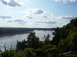
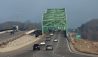
The Manitou Bluffs, or Big Manitou Bluffs, are a series of cliffs and bluffs along the Missouri River in Boone County, Missouri. They are made of Mississippian limestone that has been exposed by the erosive action of the Missouri River over time as it cuts into the Ozark Plateau. The bluffs are located between the towns of Rocheport and Huntsdale. The Katy Trail State Park runs between the bluffs and the river. Interstate 70 crosses the Missouri River on the Rocheport Bridge. Les Bourgeois Winery famously sits atop the bluffs.
Hart Creek Conservation Area is a nature preserve in Boone County, Missouri. It is named after Hart Creek, which runs through the area. It is adjacent to the Katy Trail State Park, which runs along its southwestern border. The area is primarily managed forest and limestone bluffs near the Missouri River. It is located near the town of Hartsburg, Missouri.