Pittsfield (CDP), Maine

Last updated

Pittsfield, Maine
USA Maine location map.svg
Red pog.svg
Pittsfield
Usa edcp location map.svg
Red pog.svg
Pittsfield
Coordinates: 44°46′54″N69°23′4″W / 44.78167°N 69.38444°W / 44.78167; -69.38444
CountryUnited States
State Maine
County Somerset
Area
[1]
  Total
9.61 sq mi (24.88 km2)
  Land9.40 sq mi (24.34 km2)
  Water0.21 sq mi (0.54 km2)
Elevation
210 ft (64 m)
Population
 (2020)
  Total
2,822
  Density300.28/sq mi (115.94/km2)
Time zone UTC-5 (Eastern (EST))
  Summer (DST) UTC-4 (EDT)
ZIP code
04967
Area code 207
FIPS code 23-58970
GNIS feature ID0573464

Pittsfield is a census-designated place (CDP) in the town of Pittsfield in Somerset County, Maine, United States. The population was 3,217 at the 2000 census.

Contents

Geography

Pittsfield is located at 44°46′54″N69°23′3″W / 44.78167°N 69.38417°W / 44.78167; -69.38417 (44.781765, −69.384352). [2]

According to the United States Census Bureau, the CDP has a total area of 9.6 square miles (24.8 km2), of which 9.4 square miles (24.2 km2) is land and 0.2 square mile (0.6 km2) (2.30%) is water.

Demographics

Historical population
CensusPop.Note
2020 2,822
U.S. Decennial Census [3]

As of the census [4] of 2000, there were 3,217 people, 1,235 households, and 864 families residing in the CDP. The population density was 343.8 inhabitants per square mile (132.7/km2). There were 1,343 housing units at an average density of 143.5 per square mile (55.4/km2). The racial makeup of the CDP was 95.68% White, 0.93% Black or African American, 0.37% Native American, 1.37% Asian, 0.16% Pacific Islander, 0.06% from other races, and 1.43% from two or more races. Hispanic or Latino of any race were 0.59% of the population.

There were 1,235 households, out of which 38.1% had children under the age of 18 living with them, 51.7% were married couples living together, 14.4% had a female householder with no husband present, and 30.0% were non-families. 25.0% of all households were made up of individuals, and 11.5% had someone living alone who was 65 years of age or older. The average household size was 2.49 and the average family size was 2.95.

In the CDP, the population was spread out, with 28.6% under the age of 18, 8.1% from 18 to 24, 28.5% from 25 to 44, 20.8% from 45 to 64, and 13.9% who were 65 years of age or older. The median age was 36 years. For every 100 females, there were 90.1 males. For every 100 females age 18 and over, there were 84.9 males.

The median income for a household in the CDP was $32,941, and the median income for a family was $40,561. Males had a median income of $31,856 versus $23,050 for females. The per capita income for the CDP was $16,236. About 11.1% of families and 12.7% of the population were below the poverty line, including 16.1% of those under age 18 and 4.5% of those age 65 or over.

Related Research Articles

<span class="mw-page-title-main">Funny River, Alaska</span> Census-designated place in Alaska, United States

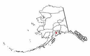
Funny River is a census-designated place (CDP) in Kenai Peninsula Borough, Alaska, United States. At the 2010 census the population was 877, up from 636 in 2000.

<span class="mw-page-title-main">Meadow Vista, California</span> Census-designated place in California, United States

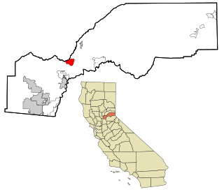
Meadow Vista is a census-designated place (CDP) in Placer County, California, United States. It is part of the Sacramento–Arden-Arcade–Roseville Metropolitan Statistical Area. The population was 3,217 at the 2010 census, up from 3,096 at the 2000 census.

<span class="mw-page-title-main">Mohawk Vista, California</span> Census-designated place in California, United States

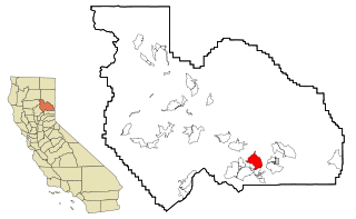
Mohawk Vista is a census-designated place in Plumas County, California, United States. The population was 159 at the 2010 census, up from 121 at the 2000 census.

<span class="mw-page-title-main">Nokomis, Florida</span> Census-designated place in Florida, United States

Nokomis is an unincorporated town in Sarasota County and a census-designated place (CDP) along the Gulf Coast of Florida, United States, located south of Osprey and just north of Venice. The town has access to the coast through Nokomis Public Beach and Casey Key. The town's population was 3,217 at the 2020 census, up from 3,167 at the 2010 census. It is part of the North Port–Bradenton–Sarasota, Florida Metropolitan Statistical Area.

<span class="mw-page-title-main">Housatonic, Massachusetts</span> Census-designated place in Massachusetts, United States

Housatonic is a census-designated place (CDP) in the town of Great Barrington in Berkshire County, Massachusetts, United States. It is part of the Pittsfield, Massachusetts Metropolitan Statistical Area. The population was 1,109 at the 2010 census. It was named after the Housatonic River.

<span class="mw-page-title-main">West Hills, Pennsylvania</span> Census-designated place in Pennsylvania, United States

West Hills is a census-designated place (CDP) in Armstrong County, Pennsylvania, United States. The population was 1,228 at the 2020 census.

<span class="mw-page-title-main">Aquia Harbour, Virginia</span> CDP in Virginia, United States

Aquia Harbour is a census-designated place (CDP) in Stafford County, Virginia, United States, 13 miles (21 km) north of Fredericksburg. The population was 6,836 at the 2020 census. Aquia Church, erected in 1757 and now a National Historic Landmark, is located west of the community.

<span class="mw-page-title-main">Adams (CDP), Massachusetts</span> Census-designated place in Massachusetts, United States

Adams is a census-designated place (CDP) located in the town of Adams in Berkshire County, Massachusetts, United States. The population was 5,515 at the 2010 census, out of 8,485 in the entire town of Adams.

<span class="mw-page-title-main">Great Barrington (CDP), Massachusetts</span> Census-designated place in Massachusetts, United States

Great Barrington is a census-designated place (CDP) located in the town of Great Barrington in Berkshire County, Massachusetts, United States. The population was 2,231 at the 2010 census, out of 7,104 in the entire town of Great Barrington.

<span class="mw-page-title-main">Carneys Point (CDP), New Jersey</span> Populated place in Salem County, New Jersey, US

Carneys Point is an unincorporated community and census-designated place (CDP) located within Carneys Point Township, in Salem County, in the U.S. state of New Jersey. As of the 2010 United States Census, the CDP's population was 7,382.

<span class="mw-page-title-main">Clinton (CDP), Maine</span> Census-designated place in Maine, United States

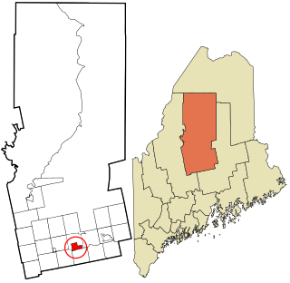
Clinton is a census-designated place (CDP) and the primary village in the town of Clinton in Kennebec County, Maine, United States. The population was 1,419 at the 2010 census, out of 3,486 in the entire town of Clinton.

<span class="mw-page-title-main">Winthrop (CDP), Maine</span> Census-designated place in Maine, United States

Winthrop is a census-designated place (CDP) comprising the primary settlement in the town of Winthrop in Kennebec County, Maine, United States. The population was 2,650 at the 2010 census, out of 6,092 in the town of Winthrop as a whole.

Dexter is a census-designated place (CDP) comprising the main settlement within the town of Dexter in Penobscot County, Maine, United States. The population of the CDP was 2,158 at the 2010 census.

Millinocket is a census-designated place (CDP) comprising most of the developed land within the town of Millinocket in Penobscot County, Maine, United States. The population of the CDP was 4,466 at the 2010 census.

<span class="mw-page-title-main">Dover-Foxcroft (CDP), Maine</span> Census-designated place in Maine, United States

Dover-Foxcroft is a census-designated place (CDP) in the town of Dover-Foxcroft in Piscataquis County, Maine, United States. The population was 2,592 at the 2000 census.

<span class="mw-page-title-main">Greenville (CDP), Maine</span> Census-designated place in Maine, United States

Greenville is a census-designated place (CDP) in the town of Greenville in Piscataquis County, Maine, United States. The population was 1,010 at the 2020 census.

<span class="mw-page-title-main">Guilford (CDP), Maine</span> Census-designated place in Maine, United States

Guilford is a census-designated place (CDP) in the town of Guilford in Piscataquis County, Maine, United States. The population was 945 at the 2000 census.

Anson is a census-designated place (CDP) in the town of Anson in Somerset County, Maine, United States. The population was 818 at the 2000 census.

Hartland is a census-designated place (CDP) in the town of Hartland in Somerset County, Maine, United States. The population was 756 at the 2020 census.

Madison is a census-designated place (CDP) in the town of Madison in Somerset County, Maine, United States. The population was 2,533 at the 2020 census.

References

  1. "2020 U.S. Gazetteer Files". United States Census Bureau. Retrieved April 8, 2022.
  2. "US Gazetteer files: 2010, 2000, and 1990". United States Census Bureau. February 12, 2011. Retrieved April 23, 2011.
  3. "Census of Population and Housing". Census.gov. Retrieved June 4, 2016.
  4. "U.S. Census website". United States Census Bureau . Retrieved January 31, 2008.