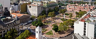
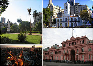
The Plaza de Mayo is a city square and main foundational site of Buenos Aires, Argentina. It was formed in 1884 after the demolition of the Recova building, unifying the city's Plaza Mayor and Plaza de Armas, by that time known as Plaza de la Victoria and Plaza 25 de Mayo, respectively. The city centre of Buenos Aires, Plaza de Mayo has been the scene of the most momentous events in Argentine history, as well as the largest popular demonstrations in the country. On the occasion of the first anniversary of the May Revolution in 1811, the Pirámide de Mayo was inaugurated in the square's hub, becoming Buenos Aires' first national monument.

The Casa Rosada is the office of the president of Argentina. The palatial mansion is known officially as Casa de Gobierno. Normally, the president lives at the Quinta de Olivos, the official residence of the president of Argentina, which is located in Olivos, Greater Buenos Aires. The characteristic color of the Casa Rosada is baby pink, and is considered one of the most emblematic buildings in Buenos Aires. The building also houses a museum, which contains objects relating to former presidents of Argentina. It has been declared a National Historic Monument of Argentina.

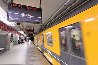
The Buenos Aires Underground, locally known as Subte, is a rapid transit system that serves the area of the city of Buenos Aires, Argentina. The first section of this network opened in 1913, making it the 13th subway in the world and the first underground railway in Latin America, the Southern Hemisphere, and the Spanish-speaking world, with the Madrid Metro opening five years later, in 1919. Currently, Buenos Aires is the only Argentine city with a metro system.

Balvanera is a barrio or neighborhood of Buenos Aires, Argentina.

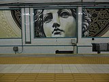
Line A is the oldest line of the Buenos Aires Underground. Opened to the public on 1 December 1913, the first underground line in South America, the Southern Hemisphere and the Spanish-speaking world. It made Buenos Aires the 13th city in the world to have an underground transport service. The line stretches 9.8 km from Plaza de Mayo and San Pedrito and runs under all of the Avenida de Mayo and part of the Avenida Rivadavia, and is used by 258,000 people per day.
The Maratón de Buenos Aires is an annual marathon foot-race which takes place in Buenos Aires, Argentina, during the Southern Hemisphere's Spring, usually in October.

Puerto Madero, also known within the urban planning community as the Puerto Madero Waterfront, is a barrio of Buenos Aires in Argentina in the central business district, occupying a significant portion of the Río de la Plata riverbank and representing the latest architectural trends.
San Isidro is a city in Greater Buenos Aires. It is located 27.9 km from the Autonomous City of Buenos Aires (CABA). It ranks as the province's most affluent neighborhood.

Buenos Aires is in the midst of a tourism boom, according to the World Travel & Tourism Council, which reveals strong growth for Argentina Travel and Tourism in 2007 and in coming years, and the prestigious travel and tourism publication; Travel + Leisure, a monthly magazine, travelers voted Buenos Aires the second most desirable city to visit after Florence, Italy. Buenos Aires, regarded as the “Paris of South America”, offers elegant architecture, exquisite cuisine, a legendary nightlife, and fashionable shopping. Argentina has become famous for its rich European flavor.
Monserrat or Montserrat is a neighbourhood in the east of the Buenos Aires CBD. The district features some of the most important public buildings in Buenos Aires, including city hall, the city legislature, Casa Rosada, the Colegio Nacional de Buenos Aires and the Libertador Building, among others.
Avenida Roque Sáenz Peña, better known as Diagonal Norte, is an important avenue in the San Nicolás neighborhood of Buenos Aires, Argentina. It is oriented south-east/north-west, diagonally bisecting the city blocks (manzanas) which give the city centre a checkerboard plan. It is named after President Roque Sáenz Peña, who held power from 1910 to 1914 and passed the law which established universal suffrage, secret ballot and an electoral register.

The Premetro is a 7.4-kilometer long (4.6 mi) light rail line that runs in the outskirts of Buenos Aires, connecting with the Buenos Aires Underground line E, at Plaza de los Virreyes station and runs to General Savio, with a short branch to Centro Cívico. It opened in 1987 and is operated by Metrovías. Originally, the Premetro was to include many more lines, but shortly after the privatisation of the railways the projects were postponed and never materialised and only "Premetro E2" was built.

Avenida Rivadavia is one of the principal thoroughfares in Buenos Aires, Argentina, extending 23 miles (37 km) from downtown Buenos Aires to the western suburb of Merlo.
There are many landmarks in Buenos Aires, Argentina some of which are of considerable historical or artistic interest.
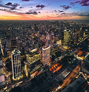
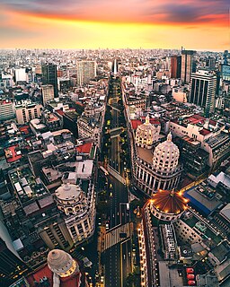
The Buenos Aires Central Business District is the main commercial centre of Buenos Aires, Argentina, though not an official city ward. While the barrios of Puerto Madero and Retiro house important business complexes and modern high-rise architecture, the area traditionally known as Microcentro is located within San Nicolás and Monserrat, roughly coinciding with the area around the historic center of the Plaza de Mayo. The Microcentro has a wide concentration of offices, service companies and banks, and a large circulation of pedestrians on working days. Another name given to this unofficial barrio is La City, which refers more precisely to an even smaller sector within the Microcentro, where almost all the banking headquarters of the country are concentrated.
Leandro N. Alem is a terminal station of the Line B of the Buenos Aires Underground. The station's name honours Leandro N. Alem, a UCR politician from the late 19th century.

Plaza Miserere is a station on Line A of the Buenos Aires Underground. The station is located between Alberti and Loria / Pasco stations on the A line underground. Plaza Miserere has interchange with Once underground station of the H line and connection to the Sarmiento line commuter rail service within Once railway station, the central station of the Domingo Faustino Sarmiento Railway.

Catedral is a terminal station of the Line D of the Buenos Aires Underground. From here, passengers may transfer to the Perú station on Line A and the Bolívar station on Line E.
The first trams in Buenos Aires began operating in 1863 in what quickly became a vast network of tramways with the city being known as the "City of Trams" for having the highest tramway-to-population ratio in the world. In the 1920s, Buenos Aires had 875 km (544 mi) of tramways and 99 tram lines using 3000 carriages running throughout the city. By 1963, the vast majority of the network began to be dismantled, though some minor tram services continue in the city today.