Pogal Paristan

Last updated
Pogal Paristan
AarJay.jpg
Nani Magar Meadows
India Jammu and Kashmir Union Territory location map.svg
Red pog.svg
Pogal Paristan
Location in Jammu and Kashmir, India
India location map.svg
Red pog.svg
Pogal Paristan
Pogal Paristan (India)
Coordinates: 33°18′47″N75°15′43″E / 33.313086°N 75.261806°E / 33.313086; 75.261806
Country India
Union Territory Jammu and Kashmir
Division Jammu Division
Region Chenab Valley
District Ramban
Established2014
Languages
  Official Urdu
Local Languages
  Spoken Pogali, Kashmiri, Urdu, Gojri
Time zone UTC+5:30 (IST)
Pincode
182145

Pogal Paristan is a valley in the Ramban district of the Chenab region in Jammu Division of the Union territory of Jammu and Kashmir, India. Since 2014 its area has constituted a separate tehsil within Ramban district. The valley is situated about 35 kilometers far from District Headquarter Ramban and 23 kilometers from Sub-District Banihal. It is situated in Ramban District in Chenab Valley which is located 150 Kilometers from Jammu and 150 kilometres from Srinagar making it almost the central point on the national highway.

Contents

Etymology

The name Pogal Paristan is derived from the names of two valleys, the Pogal and Paristan Valleys. The name Paristan is derived from Muslim folklore. It means land of the fairies . [1]

Geography

The Pogal Valley lies on the southeast end of Tehsil Banihal, and a stream known as 'Sundari'or pogal stream, The two rivers of pogal and paristan meet and forms a river called as 'Madhumati' runs through it. The Paristan Valley is a narrow valley situated at the southeast end of Tehsil Banihal that runs roughly east to west. Its south side is a forest-covered mountain range of considerable elevation, while the north is a range of mostly bare and stony hills. The path from Kishtwar to Kashmir, by the Nandmarg pass, crosses the Paristan Valley; it is used early in the season before the Brari Bal route becomes usable. A village in the valley named Paristan, which is a part of the Banihal area, lies along this path. It Paristan is located on a spur above the west side of the village of Halan. The valley contains large villages but does contain numerous hamlets and a considerable amount of agricultural cultivation. [1]

In 2014, Pogal Paristan Tehsil was carved out of Banihal Tehsil. [2] The valley comprises a Block Development Constituency (BDC) where current BDC is Karleep Singh Bali in 2022, two District Development Constituencies, and nineteen Panchayats. There are ten revenue villages in the tehsil; Pogal, Panchal, Alinbass, Muthlal, Hochak, Paristan, Senabathi, Bingara, Nardyal, Dhanmasta, and Yamuna.[ citation needed ]

Economy

Inhabitants in Pogal Paristan are mostly agricultural, and grow crops such as maize, potatoes, and pluses (rajma). Fruits like apple, apricot, peach, quince, anjeer (fig), plum are also grown. Walnuts are also grown in this region.[ citation needed ]

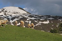
The place has several scenic and valiant niches, i.e. Chapnagla, Pasthati etc. Some most famous tourist spot include Sunaseri, Sarwadhar, Hinjni, Dhoobdanda' Tookra' Hummergali, Kakargali, Googli Dhar, Beranbass in Paristan area and Sargali, Rohan Top, Taparwan, Hansraj top in Pogal area.The only thing that requires attention is better road connectivity.[ citation needed ]

Weather

The climate is described as pleasant in the summer and cold and harsh in the winter. [3]

Streams

The two major streams in Pogal Paristan are the 'Sundari' or 'Pogal Stream' and the Paristan (or Peristan) stream. The Paritsan stream flows west from its headwaters on a mountain at the north-east end of the valley, while the Sundari (Pogal Stream) flows southwest down the southern slopes of the Nandimarg Mountain, until the two unite upstream of the Paristan (Peristan) Stream's junction with the Madhumati River. The banks of the Paristan (Peristan) Stream are mostly high and steep, especially on its north side. It is bridged just west of the Village of Chewly. A ford is located a short distance upstream of the bridge, and its possible that there are more in other parts of the river. [1]

Related Research Articles

<span class="mw-page-title-main">Chenab River</span> River in India and Pakistan

The Chenab River is a major river that flows in India and Pakistan, and is one of the 5 major rivers of the Punjab region. It is formed by the union of two headwaters, Chandra and Bhaga, which rise in the upper Himalayas in the Lahaul region of Himachal Pradesh, India. The Chenab flows through the Jammu region of Jammu and Kashmir, India into the plains of Punjab, Pakistan, before ultimately flowing into the Indus River. The Battle of Chenab was fought between Sikhs and Afghans on the bank of the river.

<span class="mw-page-title-main">Doda district</span> District in Jammu and Kashmir

Doda district is an administrative district of the Jammu division of Indian-administered Jammu and Kashmir in the disputed Kashmir region.

<span class="mw-page-title-main">Banihal Pass</span> Roadway pass connecting Kashmir

Banihal Pass is a mountain pass across the Pir Panjal Range in India at a maximum elevation of 2,832 m (9,291 ft). It connects the Kashmir Valley in the Indian union territory of Jammu and Kashmir to the outer Himalaya and the plains to the south. In the Kashmiri language, "Banihāl" means blizzard.

<span class="mw-page-title-main">Pir Panjal Range</span> Mountain range of the Lower Himalayas

The Pir Panjal Range is a range of mountains in the Lower Himalayan region located in the Western Himalayas of northern Indian subcontinent. It runs southeast to northwest between the Beas and Neelam/Kishanganga rivers, in the Indian state of Himachal Pradesh and Indian-administered union territory of Jammu and Kashmir, with its northwestern end extending into territory administered by Pakistan. The Himalayas show a gradual elevation towards the Dhauladhar and Pir Panjal ranges. Pir Panjal is the largest and westernmost range of the Lesser Himalayas. Near the bank of the Sutlej River, it dissociates itself from the main Himalayan range and forms a divide between the Beas and Ravi rivers on one side and the Chenab on the other. Further west, the Pir Panjal range forms the southwestern boundary of the Kashmir Valley, separating it from the hills of Jammu region, forming a divide between the Jhelum and Chenab rivers.

The Jammu–Baramulla line is a railway track being laid to connect the Kashmir Valley in the Indian union territory of Jammu and Kashmir with Jammu railway station and thence to the rest of the country. The 338 km railway track will start from Jammu and end at Baramulla. It comes under the jurisdiction of the Firozpur railway division of Indian Railways' Northern zone. Part of this railway route from Udhampur to Baramulla is known as Udhampur-Srinagar-Baramula Rail Link (USBRL). The 359 m (1,178 ft) tall Chenab Bridge lies on this line, which is the tallest railway bridge in the world. The total project cost in 2022 was INR28,000 crore.

<span class="mw-page-title-main">Banihal</span> Town in Jammu and Kashmir, India

Banihal is a town and a notified area committee, near Ramban town in Ramban district in the Indian union territory of Jammu and Kashmir. It is a rural and hilly area with Kamirwah being one of the most prominent hills. It is located about 35 km (22 mi) away from Qazigund of Anantnag district on NH 44. However, the distance between Banihal and Qazigund is only 18 km by train on the new railway line which is much shorter than the road. The most common language spoken in the region is Kashmiri; Urdu, Hindi, Gujjari, Pahari and English are other familiar languages.

<span class="mw-page-title-main">Ramban, Jammu and Kashmir</span> Town in Jammu and Kashmir, India

Ramban is a town in Ramban district of Jammu and Kashmir, India, which is the district headquarters of Ramban district. It lies on the banks of the Chenab river in Chenab Valley on the National Highway-1A at about 120 km from Jammu and about 130 km from Srinagar, making it almost the central point on the Jammu-Srinagar National Highway.

<span class="mw-page-title-main">Tourism in Jammu and Kashmir</span> Tourist places in Jammu and Kashmir

Jammu and Kashmir is home to several valleys such as the Kashmir Valley, Chenab Valley, Sindh Valley and Lidder Valley. Some major tourist attractions in Jammu and Kashmir are Srinagar, with its renowned Dal Lake and Mughal Gardens, Gulmarg, Pahalgam, Bhaderwah, Patnitop and Jammu. Every year, thousands of Hindu pilgrims visit holy shrines of Vaishno Devi and Amarnath which has had a significant impact on the state's economy.

<span class="mw-page-title-main">Ramban district</span> District of Jammu and Kashmir administered by India

Ramban district is an administrative district in the Jammu division of Indian-administered Jammu and Kashmir in the disputed Kashmir region. It is located in a valley surrounded the Pir Panjal range. It was carved out as a separate district from erstwhile Doda district in 2007. It is located in the Jammu division. The district headquarters are at Ramban town, which is located midway between Jammu and Srinagar along the Chenab river in the Chenab valley on National Highway-44, approximately 151 km from Jammu and Srinagar.

<span class="mw-page-title-main">Kishtwar district</span> District of Jammu and Kashmir, India

Kishtwar district is an administrative district of the Jammu division of Indian-administered Jammu and Kashmir in the Jammu Division. As of 2011, it is the largest and the least populous district of Jammu and Kashmir.

<span class="mw-page-title-main">Fairoz Khan</span> Indian politician

Fairoz Khan is an activist and former president of the National Students' Union of India. On 11 April 2022, he was appointed as Working President of Pradesh Youth Congress J&K.

<span class="mw-page-title-main">Chenab Valley</span> Valley and proposed administrative division in Jammu and Kashmir, India

The Chenab Valley is a river valley formed by the Chenab River. The term is also used collectively for Doda, Kishtwar and Ramban districts of Jammu Division in the Indian-administered Jammu and Kashmir. These districts were formerly part of a single district, called Doda.

Sangaldan is a town and block, near Ramban town in the Ramban district of the Indian union territory of Jammu and Kashmir. It falls in the Gool-Gulabgarh area of the Chenab valley.

<span class="mw-page-title-main">Banihal railway station</span> Railway station in Banihal, Jammu and Kashmir

Banihal railway station, a part of Jammu–Baramulla line, is situated in notified area of Banihal in Ramban district, Jammu and Kashmir. It was commissioned on 26 June 2013 and passenger trains run from Banihal to Qazigund. The station was inaugurated by former prime minister Manmohan Singh and UPA Chairperson Sonia Gandhi on the same day at 2.22 pm. They enjoyed the 12-minute ride in train through Pir Panjal tunnel up to Qazigund with 100 students, mostly girls, of the Banihal Higher Secondary School, and made the 17.8-km ride back to Banihal, passing through the tunnel again, the second longest in Asia.

Devi Das Thakur was an Indian politician and a former Governor of Assam.

Sangaldan Railway Station is a railway station in Ramban district, Jammu and Kashmir. Its code is SGDN. It serves Sangaldan block, Gool Sub-division and Ramban District. The station has three platforms. The station lies on Banihal–Katra line. The Work on this rail line upto Sangaldan has been completed in February 2024. The station in surrounded by many of long tunnels of Jammu–Baramulla line.

<span class="mw-page-title-main">Warwan Valley</span> Valley in Jammu and Kashmir, India

The Warwan Valley is a Himalayan sub-valley and a tehsil in Kishtwar District in the Jammu division in union territory of Jammu and Kashmir in India. The Valley lies 68 kilometres (42 mi) northeast of Kishtwar and 150 kilometres (93 mi) from Srinagar, the summer capital of Jammu and Kashmir.

<span class="mw-page-title-main">Jai Valley</span> Tourist destination in Jammu and Kashmir

Jai Valley is an enchanting valley located 32 kilometres (20 mi) northeast of Bhaderwah town in Jammu and Kashmir, India. The Bhaderwah-Jai road, which passes through the corniferous deodar forests of Nakshri, Balote, Bhalara and Chinta Valley connects the valley with the Bhaderwah town. The valley has green meadows which act as the attraction for tourists in summers and the snow-covered landscape during winters. Jai valley has about 9 kilometres (5.6 mi) long meadows, bisected by a stream called Jai Nallah which merges with a tributary of river Chenab at Kahara in tehsil Thathri. It is also known by the names Jai Garh and Jai Top. The valley is also connected through a 37 kilometres (23 mi) long road with Gandoh. There is no Mobile Network in this valley.

Pogali, or Poguli, is an Indo-Aryan language spoken in parts of the Chenab Valley in Jammu region of Jammu and Kashmir, India. Its area encompasses the Pogal and Paristan, Ramsu Banihal Khari Reasi valleys, and currently falls within the boundaries of Ramban district's Pogal Paristan tehsil.Pogali is much mixed with Pahari and Zundhari, and forms a transition dialect. In 1911 the number of speakers was reported to be 8,158.Like its neighbours Sarazi and Rambani, Pogali is intermediate between Kashmiri and Western Pahari. During 1990s Some Pogali community families migrated due terrorism from Pogal Paristan to Ramban town and different parts of Udhampur District and Jammu District which have now thousands Pogali population resided permanently. But State and Central government did recognized as minority language in UT and India.

References

  1. 1 2 3 "Pogal Paristan : Land of Fairies". Travel The Himalayas. 16 July 2019. Retrieved 4 August 2020.
  2. "POGAL FESTIVAL, District Ramban". 2022-09-03. Retrieved 2023-08-16.
  3. "Places of Interest". Ramban administration (Government of Jammu and Kashmir). Retrieved 3 August 2020.

most beautiful places for tracking or campaign. Marg. Hansraj. Sunaseri. Sharwadhar. Sargali.