Polar Earth Observing Network

Last updated

The Polar Earth Observing Network (POLENET) is a global network involving researchers from 24 nations for the geophysical observation of the polar regions of our planet. [1]

Contents

POLENET focuses mainly on data collection of GPS (Global Position System) and seismic sensors, by means of autonomous systems. Its research includes geophysical observations such as changes in magnetic fields as well as tide gauge and gravity measurements. It also makes use of deep-sea multi-sensor observatories as well as space and airborne remote sensing. [2] Data is collected from equipment spanning much of the Antarctic and the Greenland ice sheets, as well as the Arctic regions of Finland, Sweden, Norway, and Russia. [3]

POLENET is able to assemble research from a consortium of Antarctic Network (ANET), Greenland Network (G-NET), Gamburtsev Antarctic Mountains Seismic Experiment (GAMSEIS), Lapland Network (LAP-NET), and Long-Term Network. [4]

Long-Term Networks

Antarctic Treaty nations are presently collecting seismic and geodetic measurements at their permanent research stations. Arctic Circle nations are doing the same. With this, long-term data sets assist in POLENET science objectives. This assists in allowing to densify measurements in many sectors of the continental-scale POLENET networks. [5]

The Antarctic networks

The Antarctic networks are following:

Antarctic Network (ANET)

West Antarctic Rift and the Transantarctic Mountains West Antarctic Rift and The Transantarctic Mountains.png
West Antarctic Rift and the Transantarctic Mountains

ANET is a GPS and seismic network that spans the area of West Antarctica and the Transantarctic Mountains (the mountain range that separates East Antarctica from West Antarctica). [6] as well as the perimeter of East Antarctica, allowing refinement of estimates of recent ice mass change of the Antarctic ice sheets. [7] The GPS component is able to assess the rise of land as ice sheets melt, reducing pressure from the mass of the ice sheets. This adjustment in land elevation is Glacial Isostatic Adjustment (GIA). [8]

ANET is assisting in the following: [9]

Backbone network

ANET has the uniqueness of having a backbone network consists of both GPS and seismic instrumentation. 

GPS Stations

The GPS stations record movement of bedrock (solid rock under loose surface material) as changes in ice mass take place.  As the bedrock deforms under the pressure of the ice sheets, it is affected by the strength of the Earth’s interior

Seismic stations

Seismic stations record data that allows researchers to analyze seismic data to help understand the geological issues taking place as changes in the ice sheets take place, including the strength of our planet's crust and underlying mantle.

The project is led by the Byrd Polar Research Center at Ohio State University (OSU). in 2023, OSU Professor and head of ANET Terry Wilson was awarded the Ivan I. Mueller Award for Distinguished Service and Leadership by the American Geophysical Union (AGU). She was a pioneer in using GPS to measure bedrock motion in the Antarctica continent and was instrumental in the deployment of the first continental-scale network of remote, autonomous GNSS and seismic instruments. [10]

The collaborators on the project include scientists at NASA’s Jet Propulsion Laboratory, New Mexico Tech, Penn State, University of Memphis, University of Texas Institute for Geophysics, and Washington University. [6] [8] ANET was initially deployed beginning in 2007-08 during the International Polar Year activities. [9]

Gamburtsev Antarctic Mountains Seismic Experiment (GAMSEIS)

An example of glacial motion in the Gamburtsev Subglacial Mountains in Antarctica. Overdeepening process.jpg
An example of glacial motion in the Gamburtsev Subglacial Mountains in Antarctica.

GAMSEIS deploys broadband seismometers to image the structure of the Gamburtsev Subglacial Mountains (GSM) of East Antarctica.

The GSM are located on the highest plateau of the continent, which is about 4000 m above sea level.

GAMSEIS seismic data has been able to provide information on the following: [11]

The seismic images from the GSM may assist in the understanding into what is causing the upward movement or elevation mechanism of the mountains, as well as the understanding of how this upward motion has shaped the formation of the East Antarctic Ice Sheet. The integrated network will provide synoptic measurements across the interior of West Antarctica, as well as much of the perimeter of East Antarctica, allowing refinement of estimates of recent ice mass change of the Antarctic ice sheets. We are measuring the steady vertical velocity field due to isostatic rebound with GPS and will constrain earth rheology (elasticity, viscosity) through seismic studies. It is led by Pennsylvania State University and Washington University at St. Louis. [12]

Arctic Circle networks

The following are the networks in the Arctic Circle:

Greenland Network (G-NET)

Greenland Greenland (orthographic projection).svg
Greenland

G-NET is a network of 46 continuous GPS stations spread across Greenland, an autonomous territory of the Kingdom of Denmark. As ice sheets there melt, the system maps the steady vertical velocity field associated with the rise of land masses after the ice sheets melt (post-glacial rebound). [13] It is also composed of 60 GNSS (Global Satellite Navigation System) for geodetic research and is considered the fundamental geodetic infrastructure in Greenland.

In 2019, a memorandum of understanding was signed by the NSF and the Danish Agency for Data Supply and Efficiency (SDFE) for the transfer of ownership and maintenance responsibility for G-NET to the Danish government and SDFE. [14]

G-NET is maintained and developed in close cooperation with the following: [15]

Like ANET, there is research that is also led by Ohio State University. [13]

Lapland Network (LAP-NET)

Map of the geological units of Fennoscandia Overview Baltic shield.tiff
Map of the geological units of Fennoscandia

LAPNET is a network of 60 seismic stations across the Arctic regions of Finland, Sweden, Norway, and Russia.

It was deployed during the third International Polar Year (IPY) of 2007–2009. [16] The project collects data of seismic waves travelling through our planet as well as instances of glacial earthquakes (seismic activity from glacial movement). [17]

Outside of natural seismic events, LAP-NET has been able to detect seismic waves from quarry blasts from local mining operations, which has supplied geological information about local, subsurface structures. The research goal is to create a 3D seismic model of the crust and upper mantle down to 670 km in northern Baltic Shield (Fennoscandian Shield). [18]

The seismic data will be compiled into a database for the global geophysical community. It is led by the University of Oulu in Finland. [17]

Related Research Articles

<span class="mw-page-title-main">International Polar Year</span> Efforts with intensive research focus on the polar regions

The International Polar Years (IPY) are collaborative, international efforts with intensive research focus on the polar regions. Karl Weyprecht, an Austro-Hungarian naval officer, motivated the endeavor in 1875, but died before it first occurred in 1882–1883. Fifty years later (1932–1933) a second IPY took place. The International Geophysical Year was inspired by the IPY and was organized 75 years after the first IPY (1957–58). The fourth, and most recent, IPY covered two full annual cycles from March 2007 to March 2009.

<span class="mw-page-title-main">Iceberg</span> Large piece of freshwater ice broken off a glacier or ice shelf and floating in open water

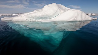
An iceberg is a piece of freshwater ice more than 15 meters long that has broken off a glacier or an ice shelf and is floating freely in open water. Smaller chunks of floating glacially derived ice are called "growlers" or "bergy bits". Much of an iceberg is below the water's surface, which led to the expression "tip of the iceberg" to illustrate a small part of a larger unseen issue. Icebergs are considered a serious maritime hazard.

<span class="mw-page-title-main">Post-glacial rebound</span> Rise of land masses after glacial period

Post-glacial rebound is the rise of land masses after the removal of the huge weight of ice sheets during the last glacial period, which had caused isostatic depression. Post-glacial rebound and isostatic depression are phases of glacial isostasy, the deformation of the Earth's crust in response to changes in ice mass distribution. The direct raising effects of post-glacial rebound are readily apparent in parts of Northern Eurasia, Northern America, Patagonia, and Antarctica. However, through the processes of ocean siphoning and continental levering, the effects of post-glacial rebound on sea level are felt globally far from the locations of current and former ice sheets.

<span class="mw-page-title-main">Byrd Polar and Climate Research Center</span>

The Byrd Polar and Climate Research Center (BPCRC) is a polar, alpine, and climate research center at Ohio State University founded in 1960.

<span class="mw-page-title-main">GRACE and GRACE-FO</span> Joint American-German space mission to map Earths gravitational field

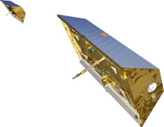
The Gravity Recovery and Climate Experiment (GRACE) was a joint mission of NASA and the German Aerospace Center (DLR). Twin satellites took detailed measurements of Earth's gravity field anomalies from its launch in March 2002 to the end of its science mission in October 2017. The two satellites were sometimes called Tom and Jerry, a nod to the famous cartoon. The GRACE Follow-On (GRACE-FO) is a continuation of the mission on near-identical hardware, launched in May 2018. On March 19, 2024, NASA announced that the successor to GRACE-FO would be Gravity Recovery and Climate Experiment-Continuity (GRACE-C), to be launched in or after 2028.

<span class="mw-page-title-main">Subglacial lake</span> Lake under a glacier

A subglacial lake is a lake that is found under a glacier, typically beneath an ice cap or ice sheet. Subglacial lakes form at the boundary between ice and the underlying bedrock, where pressure decreases the pressure melting point of ice. Over time, the overlying ice gradually melts at a rate of a few millimeters per year. Meltwater flows from regions of high to low hydraulic pressure under the ice and pools, creating a body of liquid water that can be isolated from the external environment for millions of years.

<span class="mw-page-title-main">Pine Island Glacier</span> Large ice stream, fastest melting glacier in Antarctica

Pine Island Glacier (PIG) is a large ice stream, and the fastest melting glacier in Antarctica, responsible for about 25% of Antarctica's ice loss. The glacier ice streams flow west-northwest along the south side of the Hudson Mountains into Pine Island Bay, Amundsen Sea, Antarctica. It was mapped by the United States Geological Survey (USGS) from surveys and United States Navy (USN) air photos, 1960–66, and named by the Advisory Committee on Antarctic Names (US-ACAN) in association with Pine Island Bay.

<span class="mw-page-title-main">Quaternary glaciation</span> Series of alternating glacial and interglacial periods

The Quaternary glaciation, also known as the Pleistocene glaciation, is an alternating series of glacial and interglacial periods during the Quaternary period that began 2.58 Ma and is ongoing. Although geologists describe this entire period up to the present as an "ice age", in popular culture this term usually refers to the most recent glacial period, or to the Pleistocene epoch in general. Since Earth still has polar ice sheets, geologists consider the Quaternary glaciation to be ongoing, though currently in an interglacial period.

The Gamburtsev Mountain Range is a subglacial mountain range located in East Antarctica, just underneath the lofty Dome A, near the Southern Pole of Inaccessibility. The range was discovered by the 3rd Soviet Antarctic Expedition in 1958 and is named for Soviet geophysicist Grigoriy A. Gamburtsev. It is approximately 1,200 kilometres (750 mi) long, and the mountains are believed to be about 2,700 metres (8,900 ft) high, although they are completely covered by over 600 metres (2,000 ft) of ice and snow. The Gamburtsev Mountain Range is about the same size as the European Alps. As of 2008, it was unknown how the mountains were formed due to the lack of data. Studies conducted during the International Polar year demonstrated that ancient plate collisions produced a core that was rejuvenated in the early to mid-Mesozoic. The main features of the range formed before 34 million years ago, when the area was covered by the present ice sheet. Current models suggest that the East Antarctic ice sheet was formed from the glaciers that began sliding down the Gamburtsev range at the end of the Eocene. Vostok Subglacial Highlands form an east extension of Gamburtsev Subglacial Mountains.

William Richard Peltier, Ph.D., D.Sc. (hc), is university professor of physics at the University of Toronto. He is director of the Centre for Global Change Science, past principal investigator of the Polar Climate Stability Network, and the scientific director of Canada's largest supercomputer centre, SciNet. He is a fellow of the Royal Society of Canada, of the American Geophysical Union, of the American Meteorological Society, and of the Norwegian Academy of Science and Letters..

Glacial earthquakes refer to a type of seismic event, with a magnitude of about 5, resulting from glacial calving events. The majority of glacial earthquake activity can be seen in the late summer and are found in Antarctica, Alaska, and Greenland. About 90% of these occur in Greenland. Glacial earthquakes occur most frequently in July, August, and September in Greenland. Seismographs are analyzed by scientists to identify and locate glacial earthquakes.

UNAVCO was a non-profit university-governed consortium that facilitated geology research and education using geodesy.

<span class="mw-page-title-main">Operation IceBridge</span> Arctic research project by NASA

Operation IceBridge (OIB) was a NASA mission to monitor changes in polar ice. It is an airborne follow-on mission to the ICESat satellite, until after the ICESat-2 mission was launched in September 2018. OIB ended in 2019.

The 20 indian Antarctic Expedition was flagged off on-board M.V. Magdalena Oldenorff from Cape Town on 30 December 2000. The team comprising a total of 51 members was led by Shri Mervin J. D’Souza from Geological Survey of India. The 20th IAE team consisted of 51 members including 34 scientists from various scientific Organizations/Universities/Departments and 17 logistic members. After successful completion of all logistics and scientific tasks the 20th IAE team returned to India in March 2002.

<span class="mw-page-title-main">Terry Wilson (scientist)</span> International leader in the study of present-day tectonics in Antarctica

Terry Jean Wilson is an international leader in the study of present-day tectonics in Antarctica. She has led large, international efforts, such as Polar Earth Observing Network (POLENET), to investigate the interactions between the Earth's crust and the cryosphere in Antarctica.

<span class="mw-page-title-main">Robin Bell (scientist)</span> American geophysicist

Robin Elizabeth Bell is Palisades Geophysical Institute (PGI) Lamont Research Professor at Columbia University's Lamont–Doherty Earth Observatory and a past President of the American Geophysical Union (AGU), 2019–2021. Dr. Bell was influential in co-ordinating the 2007 International Polar Year and was the first woman to chair the National Academy of Sciences Polar Research Board. She has made numerous important discoveries with regard to subglacial lakes and ice sheet dynamics, and has a ridge, called Bell Buttress, in Antarctica named after her.

<span class="mw-page-title-main">Late Cenozoic Ice Age</span> Ice age of the last 34 million years, in particular in Antarctica

The Late Cenozoic Ice Age, or Antarctic Glaciation, began 34 million years ago at the Eocene-Oligocene Boundary and is ongoing. It is Earth's current ice age or icehouse period. Its beginning is marked by the formation of the Antarctic ice sheets.

Kirsteen Jane Tinto is a glaciologist known for her research on the behavior and subglacial geology of the Greenland and Antarctic ice sheets.

Ruth Mottram is a British climate scientist who is a researcher at the Danish Meteorological Institute. Her research considers the development of climate models and the dynamics of glaciers and ice sheets in the climate system.

The Geodetic Facility for the Advancement of Geoscience (GAGE) is a geophysical facility for geoscience research and education. It focuses on research of our planet's surface deformation with unprecedented temporal and spatial resolution. GAGE is one of the two premier geophysical facilities in support of geoscience and geoscience education of the National Science Foundation (NSF). The other premiere geophysical facility is SAGE, the Seismological Facility for the Advancement of Geoscience.

References

  1. "What is POLENET?".
  2. "The Antarctic Polar Earth Observing Network (POLENET) Challenges of Autonomous and Continuous GPS/GNSS Observations at Remote Sites" (PDF).
  3. "About POLENET".
  4. Projects | POLENET: The Polar Earth Observing Network
  5. Long-Term Network | POLENET: The Polar Earth Observing Network
  6. 1 2 ANET | POLENET: The Polar Earth Observing Network
  7. Wilson, T.; Wiens, D.; Smalley, B.; Raymond, C.; Nyblade, A.; Huerta, A.; Dalziel, I.; Bevis, M.; Aster, R.; Anandakrishnan, S. (2008-12-01). "POLENET Seismic and GPS Network in West Antarctica". American Geophysical Union . 2008: V11F–02.
  8. 1 2 "The Antarctic Sun: News about Antarctica - POLENET (page 1)". antarcticsun.usap.gov. Retrieved 2024-06-16.
  9. 1 2 "Antarctic Network - Polar Earth Observing Network: Achievements from Ten Years of Autonomous Measurements".
  10. "Professor Terry Wilson Receives AGU's Ivan I. Mueller Award for Distinguished Service and Leadership | Byrd Polar and Climate Research Center". byrd.osu.edu. Retrieved 2024-06-17.
  11. "An Overview of Seismological Projects during the International Polar Year".
  12. GAMSEIS | POLENET: The Polar Earth Observing Network
  13. 1 2 GNET | POLENET: The Polar Earth Observing Network
  14. U.S, Arctic Research Consortium of the. "The Future Shape of the Greenland Geodetic Network". www.arcus.org. Retrieved 2024-06-16.
  15. "GNET, Greenland GNSS-Network, is a global reference frame for geodesy".
  16. "POLENET/LAPNET teleseismic P wave travel time tomography model of the upper mantle beneath northern Fennoscandia".
  17. 1 2 LAP-NET | POLENET: The Polar Earth Observing Network
  18. "FDSN: XK (2007-2009): POLENET/LAPNET". www.fdsn.org. Retrieved 2024-06-16.

Greenland GNSS Network