
The Lusatian Neisse, or Western Neisse, is a 252-kilometre (157 mi) river in northern Central Europe. It rises in the Jizera Mountains, near Nová Ves nad Nisou, at the Czech border becoming the Polish–German border for its remaining 197 kilometres (122 mi), to flow into the similarly northward-flowing Oder from the left.
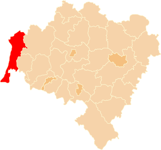
Zgorzelec County is a unit of territorial administration and local government (powiat) in Lower Silesian Voivodeship, Poland. It came into being on January 1, 1999, as a result of the Polish local government reforms passed in 1998. It is situated in the extreme south-west of Poland, bordering both Germany and the Czech Republic. The county covers an area of 838.1 square kilometres (323.6 sq mi). Its administrative seat is Zgorzelec, on the German border; the other towns in the county are Bogatynia, Pieńsk, Zawidów and Węgliniec.

Zittau is the southeasternmost city in the German state of Saxony, and belongs to the district of Görlitz, Germany's easternmost district.

Upper Lusatia is a historical region in Germany and Poland. Along with Lower Lusatia to the north, it makes up the region of Lusatia, named after the Slavic Lusici tribe. Both parts of Lusatia are home to the West Slavic minority group of the Sorbs.

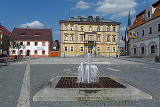
Bogatynia is a town in Zgorzelec County, Lower Silesian Voivodeship, in south-western Poland. As of December 2021, the town had a population of 16,460.
Hrádek nad Nisou is a town in Liberec District in the Liberec Region of the Czech Republic. It has about 7,900 inhabitants. The historic town centre is well preserved and is protected by law as an urban monument zone.
Gmina Bogatynia is an urban-rural gmina in Zgorzelec County, Lower Silesian Voivodeship, in south-western Poland, bordering both the Czech Republic and Germany. Its seat is the town of Bogatynia, which lies approximately 27 kilometres (17 mi) south of Zgorzelec, and 147 kilometres (91 mi) west of the regional capital Wrocław.

Białopole is a village in the administrative district of Gmina Bogatynia, within Zgorzelec County, Lower Silesian Voivodeship, in south-western Poland, close to the Czech and German borders.

Bratków is a village in the administrative district of Gmina Bogatynia, within Zgorzelec County, Lower Silesian Voivodeship, in south-western Poland. It is located in a Polish salient between the Czech Republic and Germany.

Działoszyn is a village in the administrative district of Gmina Bogatynia, within Zgorzelec County, Lower Silesian Voivodeship, in south-western Poland, close to the Czech and German borders.

Jasna Góra is a village in the administrative district of Gmina Bogatynia, within Zgorzelec County, Lower Silesian Voivodeship, in south-western Poland, close to the Czech and German borders. Founded during the Piast dynasty in the 1300s, it was seized by Germany prior to its return in 1945.

Kopaczów is a village in the administrative district of Gmina Bogatynia, within Zgorzelec County, Lower Silesian Voivodeship, in south-western Poland, close to the Czech and German borders.

Krzewina is a village in the administrative district of Gmina Bogatynia, within Zgorzelec County, Lower Silesian Voivodeship, in south-western Poland, close to the Czech and German borders. It lies approximately 12 kilometres (7 mi) north of Bogatynia, 16 km (10 mi) south of Zgorzelec, and 147 km (91 mi) west of the regional capital Wrocław.

Lutogniewice is a village in the administrative district of Gmina Bogatynia, within Zgorzelec County, Lower Silesian Voivodeship, in south-western Poland, close to the Czech and German borders.

Opolno-Zdrój is a village in the administrative district of Gmina Bogatynia, within Zgorzelec County, Lower Silesian Voivodeship, in south-western Poland, close to the Czech and German borders.

Posada is a village in the administrative district of Gmina Bogatynia, within Zgorzelec County, Lower Silesian Voivodeship, in south-western Poland. It is located in a Polish salient between the Czech Republic and Germany.

Sieniawka is a village in the administrative district of Gmina Bogatynia, within Zgorzelec County, Lower Silesian Voivodeship, in south-western Poland, close to the Czech and German borders.
Wyszków is a village in the administrative district of Gmina Bogatynia, within Zgorzelec County, Lower Silesian Voivodeship, in south-western Poland, close to the Czech and German borders.

Rybarzowice is a former village in the administrative district of Gmina Bogatynia, within Zgorzelec County, Lower Silesian Voivodeship, in south-western Poland, close to the Czech and German borders. The village ceased to exist after 2000, when the last house was demolished.
Sulików is a village in Zgorzelec County, Lower Silesian Voivodeship, in south-western Poland. It is the seat of the administrative district (gmina) called Gmina Sulików, close to the Czech border.


