
The Atlantic Ocean is the second-largest of the world's five oceans, with an area of about 85,133,000 km2 (32,870,000 sq mi). It covers approximately 17% of Earth's surface and about 24% of its water surface area. It is known to separate the "Old World" of Africa, Europe, and Asia from the "New World" of the Americas in the European perception of the World.

The American Civil War was a civil war in the United States between the Union and the Confederacy, formed by states that had seceded from the Union. The cause of the war was the dispute over whether slavery would be permitted to expand into the western territories, leading to more slave states, or be prevented from doing so, which many believed would place slavery on a course of ultimate extinction.

The Andes, Andes Mountains or Andean Mountain Range are the longest continental mountain range in the world, forming a continuous highland along the western edge of South America. The range is 8,900 km (5,530 mi) long, 200 to 700 km wide, and has an average height of about 4,000 m (13,123 ft). The Andes extend from north to south through seven South American countries: Venezuela, Colombia, Ecuador, Peru, Bolivia, Chile and Argentina.

The Confederate States of America (CSA), commonly referred to as the Confederate States (C.S.), the Confederacy, or the South, was an unrecognized breakaway republic in the Southern United States that existed from February 8, 1861, to May 9, 1865. The Confederacy comprised eleven U.S. states that declared secession and warred against the United States during the American Civil War. The states were South Carolina, Mississippi, Florida, Alabama, Georgia, Louisiana, Texas, Virginia, Arkansas, Tennessee, and North Carolina.

The jaguar is a large cat species and the only living member of the genus Panthera native to the Americas. With a body length of up to 1.85 m and a weight of up to 158 kg (348 lb), it is the biggest cat species in the Americas and the third largest in the world. Its distinctively marked coat features pale yellow to tan colored fur covered by spots that transition to rosettes on the sides, although a melanistic black coat appears in some individuals. The jaguar's powerful bite allows it to pierce the carapaces of turtles and tortoises, and to employ an unusual killing method: it bites directly through the skull of mammalian prey between the ears to deliver a fatal blow to the brain.

Marsupials are any members of the mammalian infraclass Marsupialia. All extant marsupials are endemic to Australasia, Wallacea and the Americas. A distinctive characteristic common to most of these species is that the young are carried in a pouch. Living marsupials include opossums, Tasmanian devils, kangaroos, koalas, wombats, wallabies, and bandicoots among others, while many extinct species, such as the thylacine, are also known.

The Americas, sometimes collectively called America, are a landmass comprising the totality of North and South America. The Americas make up most of the land in Earth's Western Hemisphere and comprise the New World.

The geographic coordinate system (GCS) is a spherical or geodetic coordinate system for measuring and communicating positions directly on the Earth as latitude and longitude. It is the simplest, oldest and most widely used of the various spatial reference systems that are in use, and forms the basis for most others. Although latitude and longitude form a coordinate tuple like a cartesian coordinate system, the geographic coordinate system is not cartesian because the measurements are angles and are not on a planar surface.

A peccary is a medium-sized, pig-like ungulate of the family Tayassuidae. They are found throughout Central and South America, Trinidad in the Caribbean, and in the southwestern area of North America. They usually measure between 90 and 130 cm in length, and a full-grown adult usually weighs about 20 to 40 kg. They represent the closest relatives of the family Suidae, which contains pigs and relatives. Together Tayassuidae and Suidae are grouped in the Suina within the Artiodactyla.
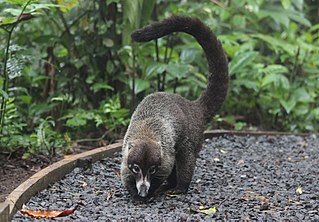
Coatis, also known as coatimundis, are members of the family Procyonidae in the genera Nasua and Nasuella. They are diurnal mammals native to South America, Central America, Mexico, and the southwestern United States. The name "coatimundi" comes from the Tupian languages of Brazil, where it means "lone coati". Locally in Belize, the coati is known as "quash".

The cougar, also known as the puma, mountain lion, catamount or panther, is a large cat native to the Americas, second only in size to the stockier jaguar. They are not technically grouped with the "true" big cats, as they are slightly smaller than other big cats, and they lack the vocal physiology to roar. Its range spans from the Canadian Provinces of the Yukon, British Columbia and Alberta, the Rocky Mountains and areas to the Western United States. Their range extends further south through Mexico, where they are found in nearly every state, to the Amazon Rainforest and the southern Andes Mountains in Patagonia. The puma inhabits every mainland country in Central and South America, making it the most widely distributed large, wild, terrestrial mammal in the Western Hemisphere, and one of the most widespread on planet Earth. It is an adaptable, generalist species, occurring in most American habitat types. It prefers habitats with dense underbrush and rocky areas for stalking but also lives in open areas.

The Appalachian Mountains, often called the Appalachians, are a mountain range in eastern to northeastern North America. Here, the term "Appalachian" refers to several different regions associated with the mountain range, and its surrounding terrain. The general definition used is one followed by the US Geological Survey and the Geologic Survey of Canada to describe the respective countries' physiographic regions. The US uses the term Appalachian Highlands and Canada uses the term Appalachian Uplands..

Megatherium is an extinct genus of ground sloths endemic to South America that lived from the Early Pliocene through the end of the Pleistocene. It is best known for the elephant-sized type species M. americanum, sometimes known as the giant ground sloth, or the megathere, native to the Pampas through southern Bolivia during the Pleistocene. Various other smaller species belonging to the subgenus Pseudomegatherium are known from the Andes.

Denali is the highest mountain peak in North America, with a summit elevation of 20,310 feet (6,190 m) above sea level. It is the tallest mountain in the world from base-to-peak on land, measuring 18,000 ft (5,500 m), and Earth's highest mountain north of 43°N. With a topographic prominence of 20,194 feet (6,155 m) and a topographic isolation of 4,621.1 miles (7,436.9 km), Denali is the third most prominent and third-most isolated peak on Earth, after Mount Everest and Aconcagua. Located in the Alaska Range in the interior of the U.S. state of Alaska, Denali is the centerpiece of Denali National Park and Preserve.

The Blue Ridge Mountains are a physiographic province of the larger Appalachian Highlands range. The mountain range is located in the Eastern United States, and extends 550 miles southwest from southern Pennsylvania through Maryland, West Virginia, Virginia, North Carolina, South Carolina, Tennessee, and Georgia. This province consists of northern and southern physiographic regions, which divide near the Roanoke River gap. To the west of the Blue Ridge, between it and the bulk of the Appalachians, lies the Great Appalachian Valley, bordered on the west by the Ridge and Valley province of the Appalachian range.

In geology and physical geography, a plateau, also called a high plain or a tableland, is an area of a highland consisting of flat terrain that is raised sharply above the surrounding area on at least one side. Often one or more sides have deep hills or escarpments. Plateaus can be formed by a number of processes, including upwelling of volcanic magma, extrusion of lava, and erosion by water and glaciers. Plateaus are classified according to their surrounding environment as intermontane, piedmont, or continental. A few plateaus may have a small flat top while others have wider ones.
In phylogenetics, basal is the direction of the base of a rooted phylogenetic tree or cladogram. The term may be more strictly applied only to nodes adjacent to the root, or more loosely applied to nodes regarded as being close to the root. Note that extant taxa that lie on branches connecting directly to the root are not more closely related to the root than any other extant taxa.

Gondwana was a large landmass, sometimes referred to as a supercontinent. It was formed by the accretion of several cratons, beginning c. 800 to 650Ma with the East African Orogeny, the collision of India and Madagascar with East Africa, and was completed c.600 to 530 Ma with the overlapping Brasiliano and Kuunga orogenies, the collision of South America with Africa, and the addition of Australia and Antarctica, respectively. Eventually, Gondwana became the largest piece of continental crust of the Palaeozoic Era, covering an area of about 100,000,000 km2 (39,000,000 sq mi), about one-fifth of the Earth's surface. It fused with Euramerica during the Carboniferous to form Pangea. It began to separate from northern Pangea (Laurasia) during the Triassic, and started to fragment during the Early Jurassic. The final stages of break-up, involving the separation of Antarctica from South America and Australia, occurred during the Paleogene (from around 66 to 23 million years ago. Gondwana was not considered a supercontinent by the earliest definition, since the landmasses of Baltica, Laurentia, and Siberia were separated from it. To differentiate it from the Indian region of the same name, it is also commonly called Gondwanaland.

A continent is any of several large geographical regions. Continents are generally identified by convention rather than any strict criteria. A continent could be a single landmass or a part of a very large landmass, as in the case of Asia or Europe. Due to this, the number of continents varies; up to seven or as few as four geographical regions are commonly regarded as continents. Most English-speaking countries recognize seven regions as continents. In order from largest to smallest in area, these seven regions are Asia, Africa, North America, South America, Antarctica, Europe, and Australia. Different variations with fewer continents merge some of these regions; examples of this are merging North America and South America into America, Asia and Europe into Eurasia, and Africa, Asia, and Europe into Afro-Eurasia.

Pangaea or Pangea was a supercontinent that existed during the late Paleozoic and early Mesozoic eras. It assembled from the earlier continental units of Gondwana, Euramerica and Siberia during the Carboniferous approximately 335 million years ago, and began to break apart about 200 million years ago, at the end of the Triassic and beginning of the Jurassic. In contrast to the present Earth and its distribution of continental mass, Pangaea was centred on the equator and surrounded by the superocean Panthalassa and the Paleo-Tethys and subsequent Tethys Oceans. Pangaea is the most recent supercontinent to have existed and the first to be reconstructed by geologists.
