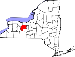
Port Gibson, New York

Last updated

Port Gibson, New York
USA New York location map.svg
Red pog.svg
Port Gibson
Usa edcp location map.svg
Red pog.svg
Port Gibson
Coordinates: 43°2′12″N77°9′16″W / 43.03667°N 77.15444°W / 43.03667; -77.15444
CountryUnited States
State New York
County Ontario
Town Manchester
Area
[1]
  Total
1.27 sq mi (3.29 km2)
  Land1.24 sq mi (3.21 km2)
  Water0.03 sq mi (0.08 km2)
Elevation
470 ft (140 m)
Population
 (2020)
  Total
405
  Density327.14/sq mi (126.26/km2)
Time zone UTC-5 (Eastern (EST))
  Summer (DST) UTC-4 (EDT)
ZIP Codes
14537 (Port Gibson)
14432 (Clifton Springs)
Area code(s) 315/680
FIPS code 36-59322
GNIS feature ID2628179 [2]

Port Gibson is a hamlet and census-designated place (CDP) in the town of Manchester, Ontario County, New York, United States. As of the 2010 census, it had a population of 453. [2]

Contents

Geography

The CDP is in northern Ontario County, in the northeast corner of the town of Manchester. It is bordered to the north by the Erie Canal. New York State Route 31, following the canal, runs through the northern edge of the community, leading east 3.5 miles (5.6 km) to Newark and northwest 5 miles (8 km) to Palmyra. The village of Manchester is 7 miles (11 km) to the southwest.

The Port Gibson United Methodist Church was listed on the National Register of Historic Places in 1996. [3] A U. S. Post Office is located in Port Gibson with a ZIP code of 14537, but a small portion of Port Gibson uses the Clifton Springs postal code of 14432.

Port Gibson is Ontario County's lone land access to the NYS Barge Canal (formerly Erie Canal).

Demographics

Historical population
CensusPop.Note
2020 405
U.S. Decennial Census [4]

Related Research Articles

<span class="mw-page-title-main">Palmyra, New York</span> Town in New York, United States

Palmyra is a town in southwestern Wayne County, New York, United States. The population was 7,975 at the 2010 census. The town is named after the ancient city Palmyra in Syria.

<span class="mw-page-title-main">Manchester, New York</span> Town in New York, United States

Manchester is a town in Ontario County, New York, United States. The population was 9,406 at the 2020 census. The town was named after one of its villages, which in turn was named after the city of Manchester in England. It was formed in 1822 from the town of Farmington.

<span class="mw-page-title-main">Titusville, New Jersey</span> Populated place in Mercer County, New Jersey, US

Titusville is an unincorporated community and census-designated place (CDP) in Hopewell Township, Mercer County, in the U.S. state of New Jersey. As of the 2020 census, the population was 633. The area includes a post office with its own ZIP Code (08560), several restaurants, gas stations, a firehouse, and a small cluster of homes. Washington Crossing State Park, dedicated to George Washington's crossing of the Delaware River in 1776, is adjacent to the community.

<span class="mw-page-title-main">Griggstown, New Jersey</span> Populated place in Somerset County, New Jersey, US

Griggstown is an unincorporated community and census-designated place (CDP) located within Franklin Township, in Somerset County, in the U.S. state of New Jersey. As of the 2010 United States Census, the CDP's population was 819. The area was first settled around 1733. The Millstone River and the Delaware and Raritan Canal both flow through Griggstown.

<span class="mw-page-title-main">East Millstone, New Jersey</span> Populated place in Somerset County, New Jersey, US

East Millstone is an unincorporated community and census-designated place (CDP) located in Franklin Township in Somerset County, in the U.S. state of New Jersey.

<span class="mw-page-title-main">Ledgewood, New Jersey</span> Populated place in Morris County, New Jersey, US

Ledgewood is an unincorporated community and census-designated place (CDP) in Roxbury Township, Morris County, New Jersey, United States. It was historically known as Drakesville after Abraham Drake, originally from Piscataway, New Jersey, who operated a mill and tavern here in the mid-1700s. The community was located on the Morris Canal. The name changed to Ledgewood on January 1, 1892.

Mount Hope is an unincorporated community and census-designated place (CDP) that is a part of Rockaway Township in Morris County, New Jersey, United States. As of the 2020 United States census, the population was 2,930.

Hemlock is a hamlet and census-designated place (CDP) in the town of Livonia, Livingston County, New York, United States. The population was 557 as of the 2010 census.

<span class="mw-page-title-main">Falls Village, Connecticut</span> Census-designated place in Connecticut, United States

Falls Village is a village and census-designated place in the town of Canaan in Litchfield County, Connecticut, United States. As of the 2010 census it had a population of 538, out of 1,234 in the entire town of Canaan. Because Falls Village is the town center and principal constituent village in Canaan, the entire town is often referred to as "Falls Village". That usage also avoids confusion of the town with Canaan Village in the town of North Canaan, Connecticut, just to the north. Falls Village derives its name from a waterfall, known as Great Falls, on the Housatonic River within the village.

<span class="mw-page-title-main">Moncure, North Carolina</span> Census-designated place in North Carolina, United States

Moncure, founded in 1881, is a small rural unincorporated community in southeastern Chatham County, North Carolina, United States. Moncure and the neighboring community of Haywood form the Moncure census-designated place (CDP), which had a population of 711 at the 2010 census. The community is located near the confluence of the Deep and Haw rivers, which form the Cape Fear River. Moncure once served as the westernmost inland port in the state, linked to the Atlantic Ocean by steamships.

<span class="mw-page-title-main">Metamora, Indiana</span> Census-designated place in Indiana, United States

Metamora is an unincorporated community and census-designated place in Metamora Township, Franklin County, Indiana. The town was once a stop along the Whitewater Canal and is now primarily dependent on tourism. As of the 2010 census, it had a population of 188.

<span class="mw-page-title-main">Witherbee, New York</span> Census-designated place in New York, United States

Witherbee is a hamlet and census-designated place (CDP) in the town of Moriah in Essex County, New York, United States. The population of the CDP was 347 at the 2010 census. Prior to 2010 the hamlet was part of the Mineville-Witherbee CDP.

<span class="mw-page-title-main">Port Murray, New Jersey</span> Census-designated place in Warren County, New Jersey, United States

Port Murray is an unincorporated community and census-designated place (CDP) located within Mansfield Township in Warren County, in the U.S. state of New Jersey, that was created as part of the 2010 United States Census. As of the 2010 Census, the CDP's population was 129.

<span class="mw-page-title-main">Port Colden, New Jersey</span> Populated place in Warren County, New Jersey, US

Port Colden is an unincorporated community and census-designated place (CDP) located within Washington Township, in Warren County, in the U.S. state of New Jersey, that was created as part of the 2010 United States Census. As of the 2010 Census, the CDP's population was 122.

<span class="mw-page-title-main">Greenbush (CDP), Wisconsin</span> Census-designated place in Wisconsin, United States

Greenbush is a census-designated place located in the town of Greenbush, Sheboygan County, Wisconsin, United States.

Piffard is a census-designated place (CDP) and hamlet in the town of York, Livingston County, New York, United States. As of the 2010 census, its population was 220. The ZIP Code is 14533.

Port Gamble Tribal Community is a census-designated place (CDP) corresponding to the Port Gamble S'Klallam Reservation in Kitsap County, Washington, United States. The population was 916 at the 2010 census.

Hunt is a hamlet and census-designated place (CDP) in Livingston County, New York, United States. Its population was 78 as of the 2010 census. Hunt has a post office with ZIP code 14846.

<span class="mw-page-title-main">Highland-on-the-Lake, New York</span> Census-designated place in New York, United States

Highland-on-the-Lake is a hamlet and census-designated place (CDP) in the town of Evans, Erie County, New York, United States. It was first listed as a CDP prior to the 2020 census.

Marcy is an unincorporated community and census-designated place (CDP) in the town of Marcy, Oneida County, New York, United States. It was first listed as a CDP prior to the 2020 census.

References

  1. "ArcGIS REST Services Directory". United States Census Bureau. Retrieved September 20, 2022.
  2. 1 2 "Port Gibson Census Designated Place". Geographic Names Information System . United States Geological Survey, United States Department of the Interior.
  3. "National Register Information System". National Register of Historic Places . National Park Service. March 13, 2009.
  4. "Census of Population and Housing". Census.gov. Retrieved June 4, 2016.