Phelps (village), New York

Last updated
Phelps, New York
Phelps NY.JPG
Pioneer Cemetery
USA New York location map.svg
Red pog.svg
Phelps, New York
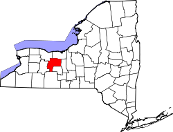
Location within the state of New York
Coordinates: 42°57′30″N77°3′44″W / 42.95833°N 77.06222°W / 42.95833; -77.06222 Coordinates: 42°57′30″N77°3′44″W / 42.95833°N 77.06222°W / 42.95833; -77.06222
Country United States
State New York
County Ontario
Area
[1]
  Total1.16 sq mi (3.00 km2)
  Land1.16 sq mi (3.00 km2)
  Water0.00 sq mi (0.00 km2)
Elevation
522 ft (159 m)
Population
 (2020)
  Total1,851
  Density1,599.83/sq mi (617.78/km2)
Time zone UTC-5 (Eastern (EST))
  Summer (DST) UTC-4 (EDT)
ZIP code
14532
Area code 315
FIPS code 36-57518
GNIS feature ID0960275

Phelps is a village in Ontario County, New York, United States. The population was 1,989 at the 2010 census. The village is named after an original proprietor, Oliver Phelps.

Contents

The Village of Phelps is near the center of the Town of Phelps and is north of Geneva.

A Sauerkraut Festival is held every August.

History

The community was first settled around 1793, one of the first locations in the town. The village was incorporated in 1855 as "Phelps," having been earlier known as "Vienna." The village had also been mockingly called "Woodpecker City," possibly to mock the villagers, who seemed always busy.

The First Baptist Church of Phelps, St. John's Episcopal Church, Phelps Town Hall, and Dr. John Quincy Howe House are listed on the National Register of Historic Places. [2]

While Phelps, New York was still known as Vienna, it was the basis for the naming of Vienna, Virginia. [3]

Geography

Phelps is located at 42°57′30″N77°3′44″W / 42.95833°N 77.06222°W / 42.95833; -77.06222 (42.958396, -77.062297). [4]

According to the United States Census Bureau, the village has a total area of 1.2 square miles (3.0 km2), all land.

Phelps is south of the New York State Thruway (Interstate 90). New York State Route 96 is an east–west highway passing through the village. The New York State Thruway passes north of the village.

Flint Creek flows through the village to the Canandaigua Outlet.

Phelps is in the Finger Lakes District and is north of Seneca Lake.

Demographics

Historical population
CensusPop.Note
1870 1,355
1880 1,3691.0%
1890 1,336−2.4%
1900 1,306−2.2%
1910 1,3543.7%
1920 1,200−11.4%
1930 1,39716.4%
1940 1,4997.3%
1950 1,65010.1%
1960 1,88714.4%
1970 1,9895.4%
1980 2,0040.8%
1990 1,978−1.3%
2000 1,969−0.5%
2010 1,9800.6%
2020 1,851−6.5%
U.S. Decennial Census [5]

As of the census [6] of 2000, there were 1,969 people, 791 households, and 521 families residing in the village. The population density was 1,684.0 people per square mile (649.8/km2). There were 877 housing units at an average density of 750.0 per square mile (289.4/km2). The racial makeup of the village was 98.48% White, 0.15% Black or African American, 0.05% Native American, 0.05% Asian, 0.61% from other races, and 0.66% from two or more races. Hispanic or Latino of any race were 1.22% of the population.

There were 791 households, out of which 31.9% had children under the age of 18 living with them, 52.8% were married couples living together, 9.2% had a female householder with no husband present, and 34.1% were non-families. 27.9% of all households were made up of individuals, and 12.0% had someone living alone who was 65 years of age or older. The average household size was 2.47 and the average family size was 3.01.

In the village, the population was spread out, with 25.6% under the age of 18, 7.0% from 18 to 24, 29.1% from 25 to 44, 23.8% from 45 to 64, and 14.5% who were 65 years of age or older. The median age was 38 years. For every 100 females, there were 90.2 males. For every 100 females age 18 and over, there were 89.9 males.

The median income for a household in the village was $40,758, and the median income for a family was $48,207. Males had a median income of $32,984 versus $24,076 for females. The per capita income for the village was $20,257. About 3.9% of families and 6.1% of the population were below the poverty line, including 9.6% of those under age 18 and 3.4% of those age 65 or over.

Related Research Articles

<span class="mw-page-title-main">Sheridan, New York</span> Town in New York, United States

Sheridan is a town in Chautauqua County, New York, United States. The population was 2,563 at the 2020 census. The town is on the county's northern border, east of Dunkirk.

<span class="mw-page-title-main">Blasdell, New York</span> Village in New York, United States

Blasdell is a village in Erie County, New York, United States. The population was 2,553 according to the 2010 Census. The name is derived from Herman Blasdell, the first station master of the Erie and Pennsylvania railroad depot. It is part of the Buffalo–Niagara Falls Metropolitan Statistical Area.

<span class="mw-page-title-main">Sloan, New York</span> Village in New York, United States

Sloan is a village in Erie County, New York, United States. The population was 3,661 at the 2010 census. It is part of the Buffalo–Niagara Falls Metropolitan Statistical Area and is in the town of Cheektowaga.

<span class="mw-page-title-main">Corfu, New York</span> Village in New York, United States

Corfu is a village in Genesee County, New York, United States. The population was 709 at the 2010 census. It is named after the Greek island of Corfu.

<span class="mw-page-title-main">Pembroke, New York</span> Town in New York, United States

Pembroke is a town in Genesee County, Western New York, United States. The population was 4,292 at the 2010 census. The town is named for a town in west Wales. Pembroke lies on the west border of Genesee County, west of Batavia.

<span class="mw-page-title-main">Stafford, New York</span> Town in New York, United States

Stafford is a town in Genesee County, New York, United States. The population was 2,459 at the 2010 census. The town was named after a town of the same name in England.

Jefferson Heights is a hamlet and census-designated place (CDP) in Greene County, New York, United States. The population was 1,122 at the 2020 census.

Leeds is a hamlet and census-designated place (CDP) in Greene County, New York, United States. The population was 377 at the 2010 census.

<span class="mw-page-title-main">Danube, New York</span> Town in New York, United States

Danube is a town in Herkimer County, New York, United States. The population was 1,039 at the 2010 census. Early Palatine German immigrants in the eighteenth century named the town after the Danube River in Europe.

Fort Johnson is a village in Montgomery County, New York, United States located on the north side of the Mohawk River in the town of Amsterdam. The population was 490 at the 2010 census.

<span class="mw-page-title-main">Westmoreland, New York</span> Town in New York, United States

Westmoreland is a town in Oneida County, New York, United States. The population was 6,138 at the 2010 census.

<span class="mw-page-title-main">Clifton Springs, New York</span> Village in New York, United States

Clifton Springs is a village located in Ontario County, New York, United States. The population was 2,127 at the 2010 census. The village takes its name from local mineral springs.

<span class="mw-page-title-main">Shortsville, New York</span> Village in New York, United States

Shortsville, officially the Village of Shortsville, is a village in Ontario County, New York, United States. The population was 1,439 at the time of the 2010 U.S. Census. Shortsville encompasses the southwestern part of the Town of Manchester and is located north of the City of Canandaigua.

<span class="mw-page-title-main">Junius, New York</span> Town in New York, United States

Junius is a town in Seneca County, New York, United States. The population was 1,370 at the 2020 census.

<span class="mw-page-title-main">Lewis Township, Union County, Pennsylvania</span> Township in Pennsylvania, United States

Lewis Township is a township in Union County, Pennsylvania, United States. The population was 1,456 at the 2020 census. Sand Bridge State Park, a Pennsylvania state park, is in Lewis Township along Pennsylvania Route 192.

<span class="mw-page-title-main">Ripley, New York</span> Town in New York, United States

Ripley is a town on Lake Erie in the westernmost part of Chautauqua County, New York, United States. The population was 2,310 at the time of the 2020 census. The town was named after Eleazer Wheelock Ripley, a general in the War of 1812. There are no incorporated villages in the town, but there is one census-designated place: the hamlet of Ripley. The town is perhaps best known as being the western end of the New York State Thruway.

<span class="mw-page-title-main">Hamburg (village), New York</span> Village in New York, United States

Hamburg is a village in Erie County, New York, United States. The population was 9,409 at the 2010 census. The village is named after Hamburg, a city in Germany. It is part of the Buffalo–Niagara Falls Metropolitan Statistical Area.

<span class="mw-page-title-main">Le Roy (village), New York</span> Village in New York, United States

Le Roy is a village in Genesee County, New York, United States. The population was 4,391 at the 2010 census. The village lies in the center of the town of Le Roy at the intersection of State Routes 5 and 19.

<span class="mw-page-title-main">Phelps, New York</span> Town in New York, United States

Phelps is a town in Ontario County, New York, United States. The population was 6,637 at the 2020 census. The Town of Phelps contains a village called Phelps. Both are north of Geneva.

Victor is an incorporated town in Ontario County, New York. The population was 15,969 at the time of the 2020 census. The town is named after Claudius Victor Boughton, an American hero of the War of 1812.

References

  1. "ArcGIS REST Services Directory". United States Census Bureau. Retrieved September 20, 2022.
  2. "National Register Information System". National Register of Historic Places . National Park Service. March 13, 2009.
  3. "Town of Vienna, Virginia, Town Government". Town of Vienna, VA. Archived from the original on 2006-02-12. Retrieved 2008-10-12. In the late 1850s, a doctor named William Hendrick agreed to settle in Ayr Hill if its name were changed to that of Vienna, his hometown in upstate New York. The Vienna, New York, that was Hendrick's hometown changed its name to Phelps in 1855.
  4. "US Gazetteer files: 2010, 2000, and 1990". United States Census Bureau. 2011-02-12. Retrieved 2011-04-23.
  5. "Census of Population and Housing". Census.gov. Retrieved June 4, 2015.
  6. "U.S. Census website". United States Census Bureau . Retrieved 2008-01-31.