
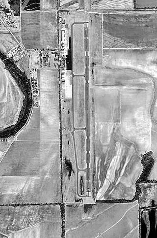
Herington Regional Airport is a public use airport in Morris County, Kansas, United States. The airport is owned by the City of Herington and is located seven nautical miles northeast of its central business district. Although the airport is in Morris County, most of Herington is located in Dickinson County. Previously known as Herington Municipal Airport, the airport is located on the site of the former Herington Army Airfield. This airport is included in the National Plan of Integrated Airport Systems for 2011–2015, which categorized it as a general aviation facility.

Grayling Army Airfield is a public/military use airport located one nautical mile (1.85 km) northwest of the central business district of Grayling, in Crawford County, Michigan, United States. It is owned by United States Army. The airfield is located 7 miles (11 km) northeast of the main cantonment area of Camp Grayling. It is included in the Federal Aviation Administration (FAA) National Plan of Integrated Airport Systems for 2017–2021, in which it is categorized as a general aviation facility.

Mefford Field is a public use airport in Tulare County, California, United States. It is owned by the City of Tulare and located three nautical miles (6 km) southeast of its central business district. This airport is included in the National Plan of Integrated Airport Systems for 2011–2015, which categorized it as a general aviation facility.

Corvallis Municipal Airport is five miles southwest of Corvallis, in Benton County, Oregon. The National Plan of Integrated Airport Systems for 2011–2015 categorized it as a general aviation facility.

Strother Field is a public airport in Cowley County, Kansas, six miles southwest of Winfield and north of Arkansas City. The airport is jointly owned by the two cities. The National Plan of Integrated Airport Systems for 2011–2015 categorized it as a general aviation facility.
Grider Field, also known as Pine Bluff Regional Airport, is a municipal airport at Pine Bluff, Arkansas. It was established in 1941 as a U.S. Army Flight Training School operated by the Pine Bluff School of Aviation. After World War II, the city turned it into a commercial airport facility. It is a 850 acre facility consisting of a large terminal and restaurant, FAA weather monitoring equipment, private corporate hangars, fixed-base operators offering fuel and avionics services, a fire station, and aviation museum. It serves as the only ILS-equipped, jet capable airport in southeast Arkansas.
Independence Municipal Airport is six miles southwest of Independence, in Montgomery County, Kansas. The National Plan of Integrated Airport Systems for 2011–2015 categorized it a general aviation facility.

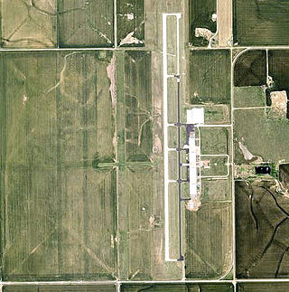
Winkler County Airport is a county-owned, public-use airport in Winkler County, Texas, United States. It is located three nautical miles (6 km) northwest of the central business district of Wink, Texas. This airport is included in the National Plan of Integrated Airport Systems for 2011–2015, which categorized it as a general aviation facility.

Mineral Wells Airport is a public airport four miles southeast of Mineral Wells, Texas. The National Plan of Integrated Airport Systems for 2011–2015 called it a general aviation facility. It is owned and operated by the city of Mineral Wells. The airport, and the city, lie in Palo Pinto County and Parker County. The terminal is in Parker County.

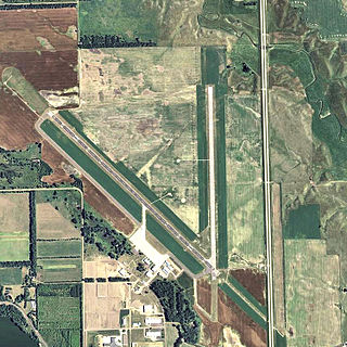
Palacios Municipal Airport is a city-owned, public-use airport located three nautical miles (6 km) northwest of the central business district of Palacios, a city in Matagorda County, Texas, United States. It is included in the National Plan of Integrated Airport Systems for 2011–2015, which categorized it as a general aviation facility.

Cross City Airport is a county-owned, public-use airport located one nautical mile (2 km) east of the central business district of Cross City, a city in Dixie County, Florida, United States. It is included in the National Plan of Integrated Airport Systems for 2011–2015, which categorized it as a general aviation facility.

Courtland Airport is a public-use airport located two nautical miles northeast of the central business district of Courtland, a town in Lawrence County, Alabama, United States. It is owned by the Lawrence County Commission and was formerly known as Lawrence County Airport.

Stuttgart Municipal Airport is in Prairie County, Arkansas. It is eight miles north of Stuttgart, which owns the airport and is the county seat of Arkansas County's northern district. The FAA's National Plan of Integrated Airport Systems for 2009–2013 categorized it as a general aviation facility.

Walnut Ridge Regional Airport is a city-owned public-use airport located four nautical miles (7 km) northeast of the central business district of Walnut Ridge, a city in Lawrence County, Arkansas, United States. According to the FAA's National Plan of Integrated Airport Systems for 2009–2013, its FAA airport category is general aviation.

Greenwood County Airport is a county-owned, public-use airport located three nautical miles (6 km) north of the central business district of Greenwood, a city in Greenwood County, South Carolina, United States. It is included in the National Plan of Integrated Airport Systems for 2011–2015, which categorized it as a general aviation facility. The airport does not have scheduled commercial airline service.

Georgetown County Airport is a county-owned, public-use airport located three nautical miles (6 km) south of the central business district of Georgetown, a city in Georgetown County, South Carolina, United States. It is included in the National Plan of Integrated Airport Systems for 2011–2015, which categorized it as a general aviation facility. The airport does not have scheduled commercial airline service.
Mitchell Municipal Airport is three miles north of Mitchell, in Davison County, South Dakota. The National Plan of Integrated Airport Systems for 2011–2015 categorized it as a general aviation airport.
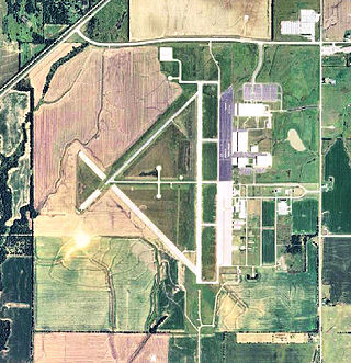
El Reno Regional Airport is in Canadian County, Oklahoma, United States, five miles southwest of El Reno, which owns it. The FAA's National Plan of Integrated Airport Systems for 2009–2013 categorized it as a general aviation facility.

Everett–Stewart Regional Airport is in Obion County, Tennessee, five miles southeast of Union City, Tennessee, United States. The National Plan of Integrated Airport Systems for 2011–2015 categorized it as a general aviation facility.

Manila Municipal Airport is a public-use airport located two nautical miles northeast of the central business district of Manila, in Mississippi County, Arkansas, United States. It is owned by the City of Manila.


