
West Yorkshire is a metropolitan and ceremonial county in the Yorkshire and the Humber region of England. It borders North Yorkshire to the north and east, South Yorkshire and Derbyshire to the south, Greater Manchester to the south-west, and Lancashire to the west. The city of Leeds is the largest settlement.
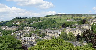
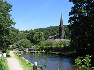
Hebden Bridge is a market town in the Calderdale district of West Yorkshire, England. It is in the Upper Calder Valley, 8 miles (13 km) west of Halifax and 14 miles (21 km) north-east of Rochdale, at the confluence of the River Calder and the Hebden Water. The town is the largest settlement in the civil parish of Hebden Royd.

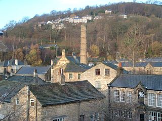
Todmorden is a market town and civil parish in the Upper Calder Valley in Calderdale, West Yorkshire, England. It is 17 miles north-east of Manchester, 8 miles (13 km) south-east of Burnley and 9 miles (14 km) west of Halifax. In 2011, it had a population of 15,481.

Calderdale is a metropolitan borough of West Yorkshire, England, which had a population of 211,439. It takes its name from the River Calder, and dale, a word for valley. The name Calderdale usually refers to the borough through which the upper river flows, while the actual landform is known as the Calder Valley. Several small valleys contain tributaries of the River Calder. The main towns of the borough are Brighouse, Elland, Halifax, Hebden Bridge, Sowerby Bridge and Todmorden.

The Calder Valley line is a railway route in Northern England between the cities of Leeds and Manchester as well as the seaside resort of Blackpool. It is the slower of the two main rail routes between Leeds and Manchester, and the northernmost of the three main trans-Pennine routes.
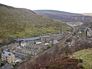
Cornholme is a village in the civil parish of Todmorden, in the metropolitan borough of Calderdale, in West Yorkshire, England. It lies at the edge of Calderdale, on the boundary with Lancashire, and in the narrow Calder Valley about 2.5 miles (4 km) north-west of Todmorden. The village is close to the A646 Burnley Road.
Hebden Royd is a civil parish in the Metropolitan Borough of Calderdale in West Yorkshire, England. According to the 2001 census it had a population of 9,092, rising to 9,558 at the 2011 census. It includes market town of Hebden Bridge and the villages of Mytholmroyd and Cragg Vale. The parish was an urban district before 1974, created in 1937 by the merger of Hebden Bridge and Mytholmroyd urban districts.
Hundersfield was a manor, parish and, from 1746, township, within the parish of Rochdale, in the hundred of Salford, England. It straddled the historic county boundary between Lancashire and the West Riding of Yorkshire. There are written references to the parish dating back to 1202.
Northowram is a village lying north-east of the town of Halifax in Calderdale, West Yorkshire, England. It stands on the north side of Shibden valley. Southowram stands on the southern side of the valley.

Cliviger is a civil parish in the Borough of Burnley, in Lancashire, England. It is situated to the southeast of Burnley, and northwest of Todmorden. According to the 2011 census, the parish has a population of 2,238.
Walsden is a large village in the civil parish of Todmorden in the Metropolitan Borough of Calderdale, West Yorkshire, England.

Eastwood is a place within the civil parish of Todmorden and Metropolitan Borough of Calderdale, in West Yorkshire, England. It lies 8 miles (12.9 km) west from Halifax, roughly equidistant from Todmorden's town centre, which is 2 miles (3.2 km) to the southwest, and Hebden Bridge, which is 2 miles to the northeast, along the course of the River Calder. Eastwood falls within the Calder ward of Calderdale council.

Gisburn is a village and civil parish within the Ribble Valley borough of Lancashire, England. Historically within the West Riding of Yorkshire, it lies 8 miles (13 km) northeast of Clitheroe and 11 miles (18 km) west of Skipton. The civil parish had a population of 506, recorded in the 2001 census, increasing to 521 at the 2011 Census.
Portsmouth railway station was on the Copy Pit line and served the village of Portsmouth, which was part of Lancashire, before being incorporated into the West Riding of Yorkshire in the late 1880s. It is now in the successor county of West Yorkshire. It opened along with the line in 1849 but was closed as an economy measure on 7 July 1958. Few traces of the station remain, although the line itself remains in use for passenger trains between Burnley and Hebden Bridge or Todmorden.
Ripponden and Barkisland railway station was opened by the Lancashire & Yorkshire Railway on the Rishworth branch in 1878 as Ripponden. Ripponden is in Calderdale, West Yorkshire, England. Its name was changed to Ripponden and Barkisland on 1 December 1891. The Lancashire and Yorkshire railway was absorbed by the London and North Western Railway on 1 January 1922, which became one of the constituents of the London, Midland and Scottish Railway on grouping in 1923. The latter company closed the station to passengers on 8 July 1929 and British Railways ceased goods traffic in 1958 after which the line was dismantled.

Mons Mill, Todmorden, is a former cotton spinning mill in Todmorden, Calderdale, West Yorkshire, England built for the Hare Spinning Company Limited. It was built in 1907, but ran into financial difficulties. It passed over to the Mons Mill (1919) Co Ltd and then was taken over by the Lancashire Cotton Corporation in 1930 and passed to Courtaulds in 1964 and production stopped in 1968. It was used into the 1990s by Ward & Goldstone Ltd. The site was cleared in 2000.

The Municipal Borough of Brighouse was a local government district in the West Riding of Yorkshire from 1873 to 1974 around the town of Brighouse, covering Clifton, Hipperholme, Hove Edge, Lightcliffe, Rastrick and Southowram.

Rishworth is a village in the civil parish of Ripponden, in Calderdale, West Yorkshire, England. Historically in the West Riding of Yorkshire, it has a small church, farms and schools, including Rishworth School. In 1931 the parish had a population of 838.
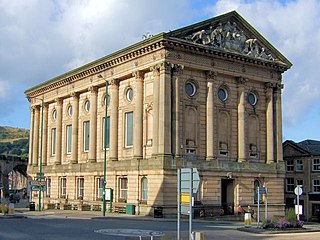
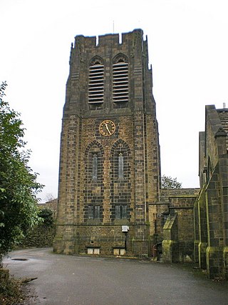
Todmorden Town Hall is a municipal building in Halifax Road, Todmorden, West Yorkshire, England. The town hall, which is the meeting place of Todmorden Town Council, is a grade I listed building.
Stansfield is a place in the civil parish of Todmorden, in the Calderdale district, in West Yorkshire, England, which gave its name to Stansfield Hall, Stansfield Hall Railway Station, and an electoral ward in Todmorden, Calderdale.


