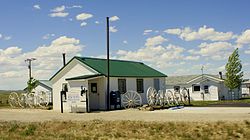
Powder River, Wyoming

Last updated

Powder River
Post Office in Powder River, Wyoming.jpg
Post Office in Powder River
WYMap-doton-PowderRiver.PNG
Location of Powder River, Wyoming
Coordinates: 43°2′5″N106°59′26″W / 43.03472°N 106.99056°W / 43.03472; -106.99056
Country United States
State Wyoming
County Natrona
Area
  Total6.0 sq mi (15.4 km2)
  Land5.9 sq mi (15.3 km2)
  Water0.0 sq mi (0.1 km2)
Elevation
5,719 ft (1,743 m)
Population
 (2020) [1]
  Total30
  Density5.0/sq mi (1.9/km2)
Time zone UTC-7 (Mountain (MST))
  Summer (DST) UTC-6 (MDT)
ZIP code
82648
Area code 307
FIPS code 56-62305 [2]
GNIS feature ID1593001 [3]

Powder River is a census-designated place (CDP) in Natrona County, Wyoming, United States. It is part of the Casper, Wyoming Metropolitan Statistical Area. The population was 30 in the 2020 census [4] and 44 in the 2010 census.

Contents

History

A post office called Powder River has been in operation since 1904. [5] The community was named after the Powder River. [6] A Chicago and Northwestern Railroad Depot built in 1910 still stands and was listed on the National Register of Historic Places in 1988. [7]

Geography

According to the United States Census Bureau, the CDP has a total area of 6.0 square miles (15.4 km2), of which 5.9 square miles (15.3 km2) is land and 0.1 square mile (0.1 km2) (0.84%) is water. [8]

Climate

Climate data for Powder River School, Wyoming, 1991–2020 normals, 1948-2020 records: 5722ft (1744m)
MonthJanFebMarAprMayJunJulAugSepOctNovDecYear
Record high °F (°C)52
(11)
59
(15)
74
(23)
80
(27)
87
(31)
100
(38)
101
(38)
101
(38)
96
(36)
86
(30)
72
(22)
64
(18)
101
(38)
Mean maximum °F (°C)47.3
(8.5)
49.4
(9.7)
65.0
(18.3)
74.3
(23.5)
81.8
(27.7)
92.8
(33.8)
97.3
(36.3)
95.6
(35.3)
92.4
(33.6)
78.6
(25.9)
65.9
(18.8)
51.8
(11.0)
96.1
(35.6)
Mean daily maximum °F (°C)33.3
(0.7)
36.1
(2.3)
46.4
(8.0)
54.3
(12.4)
65.0
(18.3)
77.1
(25.1)
87.1
(30.6)
85.1
(29.5)
74.6
(23.7)
58.4
(14.7)
44.5
(6.9)
33.8
(1.0)
58.0
(14.4)
Daily mean °F (°C)22.2
(−5.4)
23.9
(−4.5)
34.3
(1.3)
41.2
(5.1)
50.6
(10.3)
60.4
(15.8)
69.3
(20.7)
67.5
(19.7)
57.5
(14.2)
43.4
(6.3)
32.3
(0.2)
21.9
(−5.6)
43.7
(6.5)
Mean daily minimum °F (°C)11.1
(−11.6)
11.7
(−11.3)
22.2
(−5.4)
28.1
(−2.2)
36.2
(2.3)
43.7
(6.5)
51.4
(10.8)
49.9
(9.9)
40.5
(4.7)
28.4
(−2.0)
20.1
(−6.6)
10.0
(−12.2)
29.4
(−1.4)
Mean minimum °F (°C)−12.5
(−24.7)
−15.3
(−26.3)
−1.2
(−18.4)
10.4
(−12.0)
23.1
(−4.9)
34.9
(1.6)
41.6
(5.3)
38.5
(3.6)
28.5
(−1.9)
12.1
(−11.1)
−3.5
(−19.7)
−14.2
(−25.7)
−21.9
(−29.9)
Record low °F (°C)−35
(−37)
−32
(−36)
−21
(−29)
−5
(−21)
17
(−8)
28
(−2)
33
(1)
31
(−1)
20
(−7)
−12
(−24)
−28
(−33)
−40
(−40)
−40
(−40)
Average precipitation inches (mm)0.43
(11)
0.51
(13)
1.14
(29)
1.41
(36)
2.28
(58)
1.45
(37)
1.11
(28)
0.82
(21)
1.11
(28)
1.38
(35)
0.58
(15)
0.77
(20)
12.99
(331)
Average snowfall inches (cm)5.9
(15)
9.4
(24)
10.4
(26)
9.6
(24)
3.2
(8.1)
tracetracetrace1.0
(2.5)
4.3
(11)
7.6
(19)
11.7
(30)
63.1
(159.6)
Source 1: NOAA [9]
Source 2: XMACIS2 (records, 2009-2023 monthly max/mins & snowfall) [10]
Climate data for Powder River No.2, Wyoming, 1991–2020 normals, 1964-2020 records: 5700ft (1737m)
MonthJanFebMarAprMayJunJulAugSepOctNovDecYear
Record high °F (°C)60
(16)
65
(18)
74
(23)
82
(28)
96
(36)
101
(38)
109
(43)
104
(40)
99
(37)
87
(31)
77
(25)
63
(17)
109
(43)
Mean maximum °F (°C)50.5
(10.3)
53.6
(12.0)
65.4
(18.6)
75.1
(23.9)
82.6
(28.1)
92.6
(33.7)
98.3
(36.8)
95.5
(35.3)
89.1
(31.7)
76.3
(24.6)
61.6
(16.4)
50.6
(10.3)
97.5
(36.4)
Mean daily maximum °F (°C)33.7
(0.9)
36.7
(2.6)
49.0
(9.4)
56.3
(13.5)
66.2
(19.0)
78.7
(25.9)
88.2
(31.2)
86.7
(30.4)
75.3
(24.1)
59.2
(15.1)
44.0
(6.7)
32.2
(0.1)
58.9
(14.9)
Daily mean °F (°C)22.0
(−5.6)
25.0
(−3.9)
35.6
(2.0)
42.7
(5.9)
51.7
(10.9)
62.2
(16.8)
70.3
(21.3)
68.8
(20.4)
58.5
(14.7)
44.9
(7.2)
31.6
(−0.2)
21.5
(−5.8)
44.6
(7.0)
Mean daily minimum °F (°C)10.2
(−12.1)
13.4
(−10.3)
22.1
(−5.5)
29.1
(−1.6)
37.3
(2.9)
45.6
(7.6)
52.3
(11.3)
50.9
(10.5)
41.8
(5.4)
30.6
(−0.8)
19.3
(−7.1)
10.8
(−11.8)
30.3
(−1.0)
Mean minimum °F (°C)−10.8
(−23.8)
−10.3
(−23.5)
1.3
(−17.1)
13.4
(−10.3)
22.5
(−5.3)
33.7
(0.9)
40.1
(4.5)
38.6
(3.7)
26.7
(−2.9)
12.0
(−11.1)
−4.1
(−20.1)
−13.4
(−25.2)
−21.6
(−29.8)
Record low °F (°C)−42
(−41)
−31
(−35)
−18
(−28)
−8
(−22)
12
(−11)
24
(−4)
30
(−1)
18
(−8)
10
(−12)
−5
(−21)
−29
(−34)
−45
(−43)
−45
(−43)
Average precipitation inches (mm)0.26
(6.6)
0.38
(9.7)
0.69
(18)
0.99
(25)
2.05
(52)
1.48
(38)
0.96
(24)
0.68
(17)
1.09
(28)
1.02
(26)
0.54
(14)
0.29
(7.4)
10.43
(265.7)
Average snowfall inches (cm)5.1
(13)
6.8
(17)
7.3
(19)
5.2
(13)
1.2
(3.0)
0.0
(0.0)
0.0
(0.0)
0.0
(0.0)
1.3
(3.3)
5.9
(15)
5.6
(14)
3.9
(9.9)
42.3
(107.2)
Source 1: NOAA (1981-2010 precip/snowfall) [11] [12]
Source 2: XMACIS2 (records & 1981-2010 monthly max/mins) [13]

Demographics

As of the census [2] of 2000, there were 51 people, 24 households, and 13 families residing in the CDP. The population density was 8.6 people per square mile (3.3/km2). There were 44 housing units at an average density of 7.4/sq mi (2.9/km2). The racial makeup of the CDP was 100.00% White.

There were 24 households, out of which 20.8% had children under the age of 18 living with them, 54.2% were married couples living together, 4.2% had a female householder with no husband present, and 41.7% were non-families. 25.0% of all households were made up of individuals, and 12.5% had someone living alone who was 65 years of age or older. The average household size was 2.13 and the average family size was 2.64.

In the CDP, the population was spread out, with 17.6% under the age of 18, 5.9% from 18 to 24, 19.6% from 25 to 44, 39.2% from 45 to 64, and 17.6% who were 65 years of age or older. The median age was 50 years. For every 100 females, there were 104.0 males. For every 100 females age 18 and over, there were 121.1 males.

The median income for a household in the CDP was $40,804, and the median income for a family was $75,487. Males had a median income of $41,786 versus $13,750 for females. The per capita income for the CDP was $32,782. None of the population or the families were below the poverty line.

Related Research Articles

<span class="mw-page-title-main">Johnson County, Wyoming</span> County in Wyoming, United States

Johnson County is a county in the north central part of the U.S. state of Wyoming. At the 2020 United States Census, the population was 8,447. The county seat is Buffalo. Kaycee is the only other incorporated town in the county.

<span class="mw-page-title-main">Washakie County, Wyoming</span> County in Wyoming, United States

Washakie County is a county in the U.S. state of Wyoming. As of the 2020 United States Census, the population was 7,685. Its county seat is Worland.

<span class="mw-page-title-main">Natrona County, Wyoming</span> County in Wyoming, United States

Natrona County is a county in the U.S. state of Wyoming. As of the 2020 United States Census, the population was 79,955, making it the second-most populous county in Wyoming. Its county seat is Casper.

<span class="mw-page-title-main">Rudyard, Montana</span> Census-designated place in Montana, United States

Rudyard is an unincorporated community and census-designated place (CDP) in Hill County, Montana, United States. The population was 258 at the 2010 census.

<span class="mw-page-title-main">Hulett, Wyoming</span> Town in Wyoming, United States

Hulett is a town in Crook County, Wyoming, United States. The population was 309 at the 2020 census.

<span class="mw-page-title-main">Atlantic City, Wyoming</span> CDP in Wyoming, United States

Atlantic City is a census-designated place (CDP) in Fremont County, Wyoming, United States. The population was 37 at the 2010 census. The community is a small mining settlement in a gulch near South Pass in southwestern Wyoming. It was founded as a mining camp following the 1867 gold rush in the region. The town declined following the end of the placer gold rush in the early 1870s, but continued to exist as advances in mining technology allowed further extraction of gold. From the 1960s until 1983, it was the location of US Steel iron ore mine. The town is accessible by gravel roads from nearby Wyoming Highway 28.

<span class="mw-page-title-main">Jeffrey City, Wyoming</span> Census-designated place in Wyoming, United States

Jeffrey City is a former uranium mining boomtown located in Fremont County, in the central part of the U.S. state of Wyoming. The town is known in Wyoming and the American West as symbol of a boomtown that went "bust" very quickly, as the mine was shut down in 1982 and over 95% of the inhabitants left the town within three years. The population was 58 at the 2010 census, far lower than its onetime population of several thousand people. For statistical purposes, the United States Census Bureau has defined Jeffrey City as a census-designated place (CDP).

<span class="mw-page-title-main">Lucerne, Wyoming</span> CDP in Wyoming, United States

Lucerne is a census-designated place (CDP) in Hot Springs County, Wyoming, United States. The population was 535 at the 2010 census.

<span class="mw-page-title-main">Smoot, Wyoming</span> Census-designated place in Wyoming, United States

Smoot is a census-designated place (CDP) in Lincoln County, Wyoming, United States. The population was 195 at the 2010 census.

<span class="mw-page-title-main">Alcova, Wyoming</span> CDP in Wyoming, United States

Alcova is a census-designated place (CDP) in Natrona County, Wyoming, United States. It is part of the Casper, Wyoming Metropolitan Statistical Area. The population was 34 at the 2020 census. Wyoming's center of population is located in the small Town of Alcova. Alcova and the nearby reservoir, Alcova Lake, are popular vacation spots with many seasonal residents.

Antelope Hills is a census-designated place in Natrona County, Wyoming, United States. It is part of the Casper, Wyoming Metropolitan Statistical Area. The population was 97 at the 2010 census.

Bessemer Bend is a census-designated place (CDP) in Natrona County, Wyoming, United States. It is part of the Casper, Wyoming Metropolitan Statistical Area. The population was 199 at the 2010 census.

<span class="mw-page-title-main">Brookhurst, Wyoming</span> CDP in Wyoming, United States

Brookhurst is a census-designated place (CDP) in Natrona County, Wyoming, United States. It is part of the Casper, Wyoming Metropolitan Statistical Area. The population was 185 at the 2010 census.

<span class="mw-page-title-main">Casper Mountain, Wyoming</span> CDP in Wyoming, United States

Casper Mountain is a census-designated place (CDP) on Casper Mountain in Natrona County, Wyoming, United States. It is part of the Casper, Wyoming Metropolitan Statistical Area. The population was 401 at the 2010 census.

Hartrandt is a census-designated place (CDP) in Natrona County, Wyoming, United States. It is part of the Casper, Wyoming Metropolitan Statistical Area and the population was 693 at the 2010 census.

Homa Hills is a census-designated place (CDP) in Natrona County, Wyoming, United States. It is part of the Casper, Wyoming Metropolitan Statistical Area. The population was 278 at the 2010 census.

Meadow Acres is a census-designated place (CDP) in Natrona County, Wyoming, United States. It is part of the Casper, Wyoming Metropolitan Statistical Area. The population was 198 at the 2010 census.

Mountain View is a census-designated place in Natrona County, Wyoming, United States. It is part of the Casper, Wyoming Metropolitan Statistical Area. The population was 96 at the 2010 census.

Red Butte is a census-designated place (CDP) in Natrona County, Wyoming, United States. It is part of the Casper, Wyoming Metropolitan Statistical Area. The population was 1,430 at the 2020 census.

Vista West is a census-designated place (CDP) in Natrona County, Wyoming, United States. It is part of the Casper, Wyoming Metropolitan Statistical Area. The population was 951 at the 2010 census.

References

  1. "2010 City Population and Housing Occupancy Status". U.S. Census Bureau. Retrieved July 13, 2012.[ dead link ]
  2. 1 2 "U.S. Census website". United States Census Bureau . Retrieved January 31, 2008.
  3. "US Board on Geographic Names". United States Geological Survey. October 25, 2007. Retrieved January 31, 2008.
  4. Census data, data.census.gov, Retrieved 17 November 2020
  5. "Natrona County". Jim Forte Postal History. Retrieved March 22, 2015.
  6. Chicago and North Western Railway Company (1908). A History of the Origin of the Place Names Connected with the Chicago & North Western and Chicago, St. Paul, Minneapolis & Omaha Railways. p. 115.
  7. "National Register Information System". National Register of Historic Places . National Park Service. November 2, 2013.
  8. "2010 Wyoming Place Names". U.S. Census Bureau. Archived from the original on April 11, 2011. Retrieved July 13, 2012.
  9. "Powder River School, Wyoming 1991-2020 Monthly Normals" . Retrieved January 5, 2024.
  10. "xmACIS". National Oceanic and Atmospheric Administration. Retrieved January 5, 2024.
  11. "Powder River No.2, Wyoming 1991-2020 Monthly Normals" . Retrieved January 7, 2024.
  12. "Powder River No.2, Wyoming 1981-2010 Monthly Normals" . Retrieved January 7, 2024.
  13. "xmACIS". National Oceanic and Atmospheric Administration. Retrieved January 7, 2024.