Powells Crossroads, Tennessee

Last updated

Powells Crossroads, Tennessee
Powells-cross-roads-283-27-tn1.jpg
Intersection of State Route 283 and State Route 27 in Powells Crossroads
Marion County Tennessee Incorporated and Unincorporated areas Powells Crossroads Highlighted 4760500.svg
Location of Powells Crossroads in Marion County, Tennessee.
Coordinates: 35°11′1″N85°28′58″W / 35.18361°N 85.48278°W / 35.18361; -85.48278
Country United States
State Tennessee
County Marion
Incorporated1976
Area
[1]
  Total4.90 sq mi (12.68 km2)
  Land4.90 sq mi (12.68 km2)
  Water0.00 sq mi (0.00 km2)
Elevation
[2]
676 ft (206 m)
Population
 (2020) [3]
  Total1,296
  Density264.65/sq mi (102.18/km2)
Time zone UTC-6 (Central (CST))
  Summer (DST) UTC-5 (CDT)
ZIP code
37397
Area code 423
FIPS code 47-60500 [4]
GNIS feature ID1298433 [2]

Powells Crossroads is a town in Marion County, Tennessee, United States. The population was 1,322 at the 2010 census, up from 1,286 in 2000. It is part of the Chattanooga, TN-GA Metropolitan Statistical Area.

Contents

Geography

Powells Crossroads is located at 35°11′1″N85°28′58″W / 35.18361°N 85.48278°W / 35.18361; -85.48278 (35.183526, -85.482900). [5] It is situated in the Sequatchie Valley around the intersection of State Route 283 and State Route 27. Whitwell lies just to the west, opposite the Sequatchie River. Walden Ridge, much of it protected by Prentice Cooper State Forest, rises prominently to the east.

According to the United States Census Bureau, the town has a total area of 4.4 square miles (11 km2), all land.

Demographics

Historical population
CensusPop.Note
1980 918
1990 1,09819.6%
2000 1,28617.1%
2010 1,3222.8%
2020 1,296−2.0%
Sources: [6] [7] [3]

As of the census [4] of 2000, there were 1,286 people, 485 households, and 392 families residing in the town. The population density was 294.0 inhabitants per square mile (113.5/km2). There were 509 housing units at an average density of 116.4 per square mile (44.9/km2). The racial makeup of the town was 99.22% White, 0.16% African American, 0.08% Native American, 0.08% Asian, 0.08% from other races, and 0.39% from two or more races. Hispanic or Latino of any race were 0.62% of the population.

There were 485 households, out of which 36.3% had children under the age of 18 living with them, 66.6% were married couples living together, 12.0% had a female householder with no husband present, and 19.0% were non-families. 17.5% of all households were made up of individuals, and 8.7% had someone living alone who was 65 years of age or older. The average household size was 2.65 and the average family size was 2.98.

In the town, the population was spread out, with 26.6% under the age of 18, 8.9% from 18 to 24, 30.6% from 25 to 44, 24.7% from 45 to 64, and 9.2% who were 65 years of age or older. The median age was 34 years. For every 100 females, there were 101.9 males. For every 100 females age 18 and over, there were 100.0 males.

The median income for a household in the town was $36,650, and the median income for a family was $42,727. Males had a median income of $33,611 versus $22,500 for females. The per capita income for the town was $17,536. About 5.8% of families and 7.1% of the population were below the poverty line, including 10.2% of those under age 18 and 11.4% of those age 65 and over.

Powells Crossroads was the filming location for parts of the 1984 movie Starman . The lake on which Karen Allen's character lived is located in the Prentice Cooper State Forest and is called Crater Lake. The truck stop scene at "Bowdarks" was also filmed nearby, at the Martin Springs exit on I-24. [8]

Related Research Articles

<span class="mw-page-title-main">Sequatchie County, Tennessee</span> County in Tennessee, United States

Sequatchie County is a county located in the U.S. state of Tennessee. As of the 2020 census, the population was 15,826. Its county seat is Dunlap. Sequatchie County is part of the Chattanooga, TN–GA Metropolitan Statistical Area.

<span class="mw-page-title-main">Marion County, Tennessee</span> County in Tennessee, United States

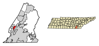
Marion County is a county located in the U.S. state of Tennessee. As of the 2020 census, the population was 28,837. Its county seat is Jasper. Marion County is part of the Chattanooga, AL–TN–GA Metropolitan Statistical Area. Marion County is in the Central time zone, while Chattanooga proper is in the Eastern time zone.

<span class="mw-page-title-main">Cumberland County, Tennessee</span> County in Tennessee, United States

Cumberland County is a county located in the U.S. state of Tennessee. As of the 2020 census, the population was 61,145. Its county seat is Crossville. Cumberland County comprises the Crossville, TN micropolitan statistical area.

<span class="mw-page-title-main">Bledsoe County, Tennessee</span> County in Tennessee, United States

Bledsoe County is a county located in the U.S. state of Tennessee. As of the 2020 census, the population was 14,913. Its county seat is Pikeville.

<span class="mw-page-title-main">Powell, Alabama</span> Town in Alabama, United States

Powell is a town in DeKalb County, Alabama, United States. At the 2020 census, the population was 901. Powell is located atop Sand Mountain.

<span class="mw-page-title-main">Buchanan, Georgia</span> City in Georgia, United States

Buchanan is a city and the county seat of Haralson County, Georgia, United States. The population was 1,104 at the 2010 census, up from 941 at the 2000 census.

<span class="mw-page-title-main">Pikeville, Tennessee</span> City in Tennessee, United States

Pikeville is a city in Bledsoe County, Tennessee. The population was 1,824 at the 2020 census. It is also the county seat of Bledsoe County.

<span class="mw-page-title-main">Gruetli-Laager, Tennessee</span> City in Tennessee, United States

Gruetli-Laager is a city in Grundy County, Tennessee, United States. The population was 1,813 at the 2010 census. As its name implies, Gruetli-Laager consists of two communities— Gruetli and Laager— incorporated as a single city.

<span class="mw-page-title-main">Palmer, Tennessee</span> Town in Tennessee, United States

Palmer is a town in Grundy County, Tennessee, United States. The population was 672 at the 2010 census.

Fairmount is a census-designated place (CDP) in Hamilton County, Tennessee, United States. The population was 2,193 at the 2020 census, down from 2,825 at the 2010 census. It is part of the Chattanooga, TN–GA Metropolitan Statistical Area.

<span class="mw-page-title-main">Walden, Tennessee</span> Town in Tennessee, United States

Walden is a town located in Hamilton County, Tennessee, United States. The population was 1,981 at the 2020 census and up from 1,898 at the 2010 census. It is part of the Chattanooga, Tennessee–Georgia Metropolitan Statistical Area.

<span class="mw-page-title-main">Parkers Crossroads, Tennessee</span> City in Tennessee, United States

Parkers Crossroads is a city in Henderson County, Tennessee, United States. The population was 330 as of the 2010 census, up from 241 at the 2000 census.

<span class="mw-page-title-main">Ridgely, Tennessee</span> Town in Tennessee, United States

Ridgely is a town in Lake County, Tennessee, United States. The population was 1,667 at the 2000 census and 1,795 at the 2010 census.

<span class="mw-page-title-main">Jasper, Tennessee</span> Town in Marion County, Tennessee

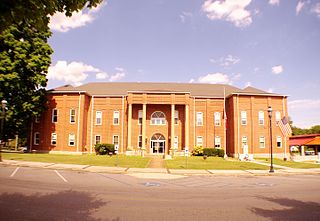
Jasper is a town in and the county seat of Marion County, Tennessee, United States. The population was 3,612 at the 2020 census. The town was formed in 1820 from lands acquired from Betsy Pack (1770–1851), daughter of Cherokee Chief John Lowery. Jasper is part of the Chattanooga, TN–GA Metropolitan Statistical Area.

<span class="mw-page-title-main">South Pittsburg, Tennessee</span> City in Tennessee, United States

South Pittsburg is a city in Marion County, Tennessee, United States. It is part of the Chattanooga, TN–GA Metropolitan Statistical Area. The population was 3,106 at the 2020 census. South Pittsburg is home to the National Cornbread Festival.

<span class="mw-page-title-main">Whitwell, Tennessee</span> City in Tennessee, United States

Whitwell is a city in Marion County, Tennessee, United States, approximately 24 miles northwest of Chattanooga. The population was 1,641 at the 2020 census. It is part of the Chattanooga, TN–GA Metropolitan Statistical Area.

<span class="mw-page-title-main">Dunlap, Tennessee</span> City in Tennessee, United States

Dunlap is a city in and the county seat of Sequatchie County, Tennessee, United States. The population was 5,357 at the 2020 census and 4,815 at the 2010 census.

<span class="mw-page-title-main">Brighton, Tennessee</span> Town in Tennessee, United States

Brighton is a town in Tipton County, Tennessee, United States. The population was 2,735 at the 2010 census.

<span class="mw-page-title-main">Viola, Tennessee</span> Town in Tennessee, United States

Viola is a town in Warren County, Tennessee, United States. The population was 129 at the 2000 census and 131 at the 2010 census.

<span class="mw-page-title-main">White Hall, West Virginia</span> Town in West Virginia, United States

White Hall is a town in Marion County, West Virginia, United States. The population was 706 at the 2020 census. Incorporated in 1989, White Hall is adjacent to the county seat, Fairmont, and is part of the Fairmont, West Virginia, Micropolitan Statistical Area. White Hall has many different stores and restaurants.

References

  1. "ArcGIS REST Services Directory". United States Census Bureau. Retrieved October 15, 2022.
  2. 1 2 U.S. Geological Survey Geographic Names Information System: Powells Crossroads, Tennessee
  3. 1 2 "Census Population API". United States Census Bureau. Retrieved October 15, 2022.
  4. 1 2 "U.S. Census website". United States Census Bureau . Retrieved January 31, 2008.
  5. "US Gazetteer files: 2010, 2000, and 1990". United States Census Bureau. February 12, 2011. Retrieved April 23, 2011.
  6. "Census of Population and Housing: Decennial Censuses". United States Census Bureau . Retrieved March 4, 2012.
  7. "Incorporated Places and Minor Civil Divisions Datasets: Subcounty Resident Population Estimates: April 1, 2010 to July 1, 2012". Population Estimates. U.S. Census Bureau. Archived from the original on June 11, 2013. Retrieved December 11, 2013.
  8. Starman Filming Locations, Fast-Rewind.com website, accessed August 22, 2009