Požeženo

Last updated
Požeženo
Village
Serbia adm location map.svg
Red pog.svg
Požeženo
Coordinates: 44°45′30″N21°34′13″E / 44.75833°N 21.57028°E / 44.75833; 21.57028
CountryFlag of Serbia.svg  Serbia
District Braničevo District
Municipality Veliko Gradište
Population (2002)
  Total 799
Time zone CET (UTC+1)
  Summer (DST) CEST (UTC+2)

Požeženo is a village in the municipality of Veliko Gradište, Serbia. According to the 2002 census, the village has a population of 799 people. [1]

Village Small clustered human settlement smaller than a town

A village is a clustered human settlement or community, larger than a hamlet but smaller than a town, with a population ranging from a few hundred to a few thousand. Though villages are often located in rural areas, the term urban village is also applied to certain urban neighborhoods. Villages are normally permanent, with fixed dwellings; however, transient villages can occur. Further, the dwellings of a village are fairly close to one another, not scattered broadly over the landscape, as a dispersed settlement.

Veliko Gradište Town and municipality in Southern and Eastern Serbia, Serbia

Veliko Gradište is a town and municipality located in the Braničevo District of the eastern Serbia. It is situated the right bank of the Danube river and left bank of the Pek river. In 2011, the town has a total population of 6,204, while the municipality has 17,610.

Serbia Republic in Southeastern Europe

Serbia, officially the Republic of Serbia, is a country situated at the crossroads of Central and Southeast Europe in the southern Pannonian Plain and the central Balkans. It borders Hungary to the north, Romania to the northeast, Bulgaria to the southeast, North Macedonia to the south, Croatia and Bosnia and Herzegovina to the west, and Montenegro to the southwest. The country claims a border with Albania through the disputed territory of Kosovo. Serbia's population numbers approximately seven million, most of whom are Orthodox Christians. Its capital, Belgrade, ranks among the oldest and largest citiеs in southeastern Europe.

Related Research Articles

Mokošín Village in Pardubice District of Pardubice region

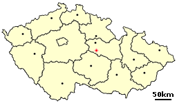
Mokošín is a village in the Pardubice Region of the Czech Republic. It has around 170 inhabitants.

Křižanovice (Chrudim District) Village in Chrudim District of Pardubice region

Křižanovice is a very small village in the Pardubice Region of the Czech Republic. It has around 120 inhabitants.

Mosna, Poland Village in Pomeranian, Poland

Mosna is a village in the administrative district of Gmina Czersk, within Chojnice County, Pomeranian Voivodeship, in northern Poland. It lies approximately 7 kilometres (4 mi) south-east of Czersk, 34 km (21 mi) east of Chojnice, and 78 km (48 mi) south-west of the regional capital Gdańsk.

Kravany, Trebišov District municipality of Slovakia in Trebišov District

Kravany is a village and municipality in the Trebišov District in the Košice Region of eastern Slovakia.

Linfield, Pennsylvania Unincorporated Village in Pennsylvania, United States

Linfield is an unincorporated village, part of Limerick Township, Montgomery County, Pennsylvania. It is located approximately 35 miles north-west of Philadelphia, along the Schuylkill River.

Grabie, Kuyavian-Pomeranian Voivodeship Village in Kuyavian-Pomeranian Voivodeship, Poland

Grabie is a village in the administrative district of Gmina Aleksandrów Kujawski, within Aleksandrów County, Kuyavian-Pomeranian Voivodeship, in north-central Poland. It lies 9 kilometres (6 mi) west of Aleksandrów Kujawski and 21 km (13 mi) south of Toruń.

Avan-Arinj Place in Yerevan, Armenia

Avan-Arinj, is a neighbourhood in the Avan District of Yerevan, Armenia.

Siciny, Kuyavian-Pomeranian Voivodeship Village in Kuyavian-Pomeranian, Poland

Siciny is a village in the administrative district of Gmina Kęsowo, within Tuchola County, Kuyavian-Pomeranian Voivodeship, in north-central Poland. It lies approximately 2 kilometres (1 mi) north-east of Kęsowo, 9 km (6 mi) west of Tuchola, and 54 km (34 mi) north of Bydgoszcz.

Təzəkənd, Lachin Place in Lachin, Azerbaijan

Təzəkənd is a village in the Lachin Rayon of Azerbaijan.

Zboiska, Krosno County Village in Subcarpathian, Poland

Zboiska is a village in the administrative district of Gmina Dukla, within Krosno County, Subcarpathian Voivodeship, in south-eastern Poland, close to the border with Slovakia. It lies approximately 1 kilometre (1 mi) north-east of Dukla, 14 km (9 mi) south of Krosno, and 57 km (35 mi) south-west of the regional capital Rzeszów.

Rzeczyca Sucha Village in Świętokrzyskie, Poland

Rzeczyca Sucha is a village in the administrative district of Gmina Dwikozy, within Sandomierz County, Świętokrzyskie Voivodeship, in south-central Poland. It lies approximately 3 kilometres (2 mi) south-west of Dwikozy, 4 km (2 mi) north of Sandomierz, and 83 km (52 mi) east of the regional capital Kielce.

Kąt, Tarnobrzeg County Village in Subcarpathian, Poland

Kąt is a village in the administrative district of Gmina Grębów, within Tarnobrzeg County, Subcarpathian Voivodeship, in south-eastern Poland. It lies approximately 1 kilometre (1 mi) north-east of Grębów, 14 km (9 mi) east of Tarnobrzeg, and 61 km (38 mi) north of the regional capital Rzeszów.

Nowa Osuchowa is a village in the administrative district of Gmina Ostrów Mazowiecka, within Ostrów Mazowiecka County, Masovian Voivodeship, in east-central Poland.

Lucin, Pomeranian Voivodeship Settlement in Pomeranian, Poland

Lucin is a settlement in the administrative district of Gmina Wicko, within Lębork County, Pomeranian Voivodeship, in northern Poland. It lies approximately 9 kilometres (6 mi) north of Wicko, 24 km (15 mi) north-west of Lębork, and 81 km (50 mi) north-west of the regional capital Gdańsk.

Borowik, West Pomeranian Voivodeship Village in West Pomeranian, Poland

Borowik is a village in the administrative district of Gmina Przybiernów, within Goleniów County, West Pomeranian Voivodeship, in north-western Poland. It lies approximately 7 kilometres (4 mi) south of Przybiernów, 17 km (11 mi) north of Goleniów, and 33 km (21 mi) north of the regional capital Szczecin.

Borchaly Uyezd Place in Uyezd, georgia

The Borchaly Uyezd was a county of the Tiflis Governorate of the Caucasus Viceroyalty of the Russian Empire and then of Democratic Republic of Georgia with its administrative center in Shulaveri. It is part of the Georgia's present day region of Kvemo Kartli.

Jasenje is a village in the municipality of Aleksinac, Serbia. According to the 2002 census, the village has a population of 210 people.

Borince Village in Jablanica District, Serbia

Borince is a village in the municipality of Bojnik, Serbia. According to the 2002 census, the village has a population of 45 people.

Klisura (Surdulica) Village in Pčinja District, Serbia

Klisura is a village in the municipality of Surdulica, Serbia. According to the 2002 census, the village has a population of 332 people.

Gaglovo is a village in the municipality of Kruševac, Serbia. According to the 2002 census, the village has a population of 811 people.

References

  1. Popis stanovništva, domaćinstava i Stanova 2002. Knjiga 1: Nacionalna ili etnička pripadnost po naseljima. Republika Srbija, Republički zavod za statistiku Beograd 2003. ISBN   86-84433-00-9

Coordinates: 44°45′30″N21°34′13″E / 44.75833°N 21.57028°E / 44.75833; 21.57028

Geographic coordinate system Coordinate system

A geographic coordinate system is a coordinate system that enables every location on Earth to be specified by a set of numbers, letters or symbols. The coordinates are often chosen such that one of the numbers represents a vertical position and two or three of the numbers represent a horizontal position; alternatively, a geographic position may be expressed in a combined three-dimensional Cartesian vector. A common choice of coordinates is latitude, longitude and elevation. To specify a location on a plane requires a map projection.