
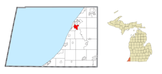
Benton Heights is an unincorporated community in Berrien County in the U.S. state of Michigan. It is also a census-designated place (CDP) for statistical purposes without any legal status as an incorporated municipality. Per the 2020 Census, the population was 3,652. The community is a part of Benton Charter Township and is adjacent to the city of Benton Harbor.
Fair Plain is an unincorporated community in Berrien County in the U.S. state of Michigan. It is a census-designated place (CDP) for statistical purposes and has no legal status as a municipality. The population was 7,402 at the 2020 census.

Presque Isle Township is a civil township of Presque Isle County in the U.S. state of Michigan. The population was 1,698 at the 2020 census.

Harbor Isle is a hamlet and census-designated place (CDP) in the Town of Hempstead in Nassau County, New York, United States. The population was 1,436 at the time of the 2020 census.

Copper Harbor is an unincorporated community and census-designated place (CDP) located in Keweenaw County in the U.S. state of Michigan. It is located within Grant Township. The population of the CDP was 136 as of the 2020 census.

Cross Village is an unincorporated community and census-designated place (CDP) in Emmet County in the U.S. state of Michigan. As of the 2010 census, the CDP had a population of 93. It is located within Cross Village Township on the shores of Lake Michigan.

Carp Lake is an unincorporated community and census-designated place (CDP) in Emmet County in the U.S. state of Michigan. As of the 2010 census, the CDP had a population of 357. It is located within Carp Lake Township.

Levering is an unincorporated community and census-designated place (CDP) in Emmet County in the U.S. state of Michigan. As of the 2010 census, the CDP had a population of 215.

Marenisco is an unincorporated community and census-designated place (CDP) in Marenisco Township, Gogebic County, Michigan, in the United States. As of the 2010 census, the CDP had a population of 254, out of a total population in the township of 1,727. The name of the community and the township was formed by combining the first three letters from Mary Enid Scott, the wife of E. H. Scott, a timber producer.

Watersmeet is an unincorporated community and census-designated place (CDP) in Watersmeet Township, Michigan. As of the 2010 census, the CDP had a population of 428, out of a total population in the township of 1,417. The community was platted in 1884, designated as a station of the Milwaukee Lake Shore and Western Railroad.

St. James is an unincorporated community and census-designated place (CDP) in Charlevoix County in the U.S. state of Michigan. The population of the CDP was 145 at the 2020 census. The community is located within St. James Township.

Jennings is an unincorporated community and census-designated place (CDP) in Missaukee County in the U.S. state of Michigan. The population was 229 at the 2020 census, down from 264 in 2010. The CDP is located mostly in Lake Township with a small portion extending north into Caldwell Township.

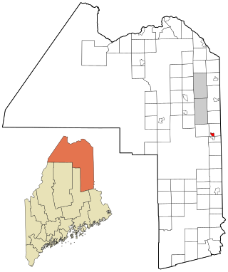
Blaine is a census-designated place (CDP) comprising the main village within the town of Blaine in Aroostook County, Maine, United States. The population of the CDP was 301 at the 2010 census, out of a population of 726 for the entire town. Prior to 2010, the village was part of the Mars Hill-Blaine CDP.

Mapleton is a census-designated place (CDP) comprising the main village within the town of Mapleton in Aroostook County, Maine, United States. The population of the CDP was 683 at the 2010 census, out of a population of 1,948 for the entire town.
Mars Hill is a census-designated place (CDP) comprising the main village within the town of Mars Hill in Aroostook County, Maine, United States. The population of the CDP was 980 at the 2010 census, out of a population of 1,493 for the entire town. Prior to 2010, the village was part of the Mars Hill-Blaine CDP.

Lakes of the North is an unincorporated community and census-designated place (CDP) in Antrim County in the U.S. state of Michigan. The CDP is located in Mancelona Township to the south and Star Township to the north. The population of the CDP was 1,044 at the 2020 census.

Lake Victoria is an unincorporated community and census-designated place (CDP) in Clinton County in the U.S. state of Michigan. It is located in Victor Township. As of the 2010 census, it had a population of 930.

Manistee Lake is an unincorporated community and census-designated place (CDP) in Kalkaska County in the U.S. state of Michigan. At the 2010 census, the CDP had a population of 456. Manistee Lake is located within Coldsprings Township to the north and a small portion extending south into Excelsior Township.

Bear Lake is an unincorporated community and census-designated place (CDP) in Kalkaska County in the U.S. state of Michigan. At the 2010 census, the CDP had a population of 327. Bear Lake is located within Bear Lake Township.
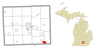
Vineyard Lake is an unincorporated community and census-designated place (CDP) in Jackson County in the U.S. state of Michigan. The CDP had a population of 980 at the 2010 census. It is located within Columbia Township to the west and Norvell Township to the east.


