Prokhladnensky District Прохладненский район(Russian) Прохладнэ къедзыгъуэ (Kabardian) Прохладна район (Karachay-Balkar) | |
---|---|
Location of Prokhladnensky District in the Kabardino-Balkar Republic | |
Coordinates: 43°45′N44°02′E / 43.750°N 44.033°E Coordinates: 43°45′N44°02′E / 43.750°N 44.033°E | |
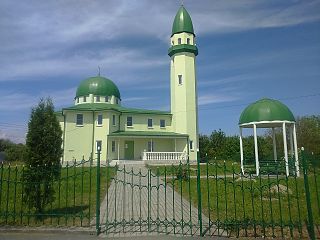
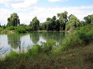
The Shakoy Spring near Yantarnoye in Prokhladnensky District | |
Location | |
Country | Russia |
Federal subject | Kabardino-Balkar Republic [1] |
Administrative structure (as of April 2014) | |
Administrative center | town of Prokhladny [1] |
Inhabited localities: [1] | |
Rural localities | 41 |
Municipal structure (as of April 2014) | |
Municipally incorporated as | Prokhladnensky Municipal District [2] |
Municipal divisions: [2] | |
Urban settlements | 0 |
Rural settlements | 19 |
Statistics | |
Area | 1,342 km2 (518 sq mi)[ citation needed ] |
Population (2010 Census) | 45,533 inhabitants [3] |
• Urban | 0% |
• Rural | 100% |
Density | 33.93/km2 (87.9/sq mi) [4] |
Time zone | MSK (UTC+03:00) [5] |
Official website | |
Prokhladnensky District on WikiCommons |
2010 Census | 45,533 [3] |
---|---|
2002 Census | 46,425 [6] |
1989 Census | 39,951 [7] |
1979 Census | 38,174 [8] |
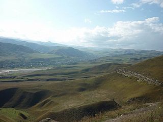
Prokhladnensky District (Russian : Прохла́дненский райо́н; Kabardian : Прохладнэ къедзыгъуэ; Karachay-Balkar : Прохладна район) is an administrative [1] and a municipal [2] district (raion), one of the ten in the Kabardino-Balkar Republic, Russia. It is located in the northeast of the republic. The area of the district is 1,342 square kilometers (518 sq mi).[ citation needed ] Its administrative center is the town of Prokhladny (which is not administratively a part of the district). [1] As of the 2010 Census, the total population of the district was 45,533. [3]
Russian is an East Slavic language, which is official in the Russian Federation, Belarus, Kazakhstan and Kyrgyzstan, as well as being widely used throughout Eastern Europe, the Baltic states, the Caucasus and Central Asia. It was the de facto language of the Soviet Union until its dissolution on 25 December 1991. Although nearly three decades have passed since the breakup of the Soviet Union, Russian is used in official capacity or in public life in all the post-Soviet nation-states, as well as in Israel and Mongolia.
Kabardian, also known as Kabardino-Cherkess (къэбэрдей-черкесыбзэ) or East Circassian, is a Northwest Caucasian language closely related to the Adyghe language. It is spoken mainly in parts of the North Caucasus republics of Kabardino-Balkaria and Karachay-Cherkessia and in Turkey, Jordan and Syria. It has 47 or 48 consonant phonemes, of which 22 or 23 are fricatives, depending upon whether one counts as phonemic, but it has only 3 phonemic vowels. It is one of very few languages to possess a clear phonemic distinction between ejective affricates and ejective fricatives.
The Karachay-Balkar language is a Turkic language spoken by the Karachays and Balkars in Kabardino-Balkaria and Karachay–Cherkessia, European Russia, as well as by an immigrant population in Afyonkarahisar Province, Turkey. It is divided into two dialects: Karachay-Baksan-Chegem, which pronounces two phonemes as and, and Balkar, which pronounces the corresponding phonemes as and. The modern Karachay-Balkar written language is based on the Karachay-Baksan-Chegem dialect. The language is closely related to Kumyk.
Within the framework of administrative divisions, Prokhladnensky District is one of the ten in the Kabardino-Balkar Republic and has administrative jurisdiction over all of its forty-one rural localities. [1] The town of Prokhladny serves as its administrative center, despite being incorporated separately as a town of republic significance—an administrative unit with the status equal to that of the districts. [1]
The classification system of the types of inhabited localities in Russia, the former Soviet Union, and some other post-Soviet states has certain peculiarities compared with the classification systems in other countries.
Prokhladny is a town in the Kabardino-Balkar Republic, Russia, located on the Malka River, 60 kilometers (37 mi) north of Nalchik. Population: 59,601 (2010 Census); 61,772 (2002 Census); 57,084 (1989 Census).
City of federal subject significance is an umbrella term used to refer to a type of an administrative division of a federal subject of Russia which is equal in status to a district but is organized around a large city; occasionally with surrounding rural territories.
As a municipal division, the district is incorporated as Prokhladnensky Municipal District. [2] Its forty-one rural localities are incorporated into nineteen rural settlements within the municipal district. [2] The town of republic significance of Prokhladny is incorporated separately from the district as Prokhladny Urban Okrug, but serves as the administrative center of the municipal district as well. [2]
The Kabardino-Balkar Republic or Kabardino-Balkaria, is a federal subject of Russia located in the North Caucasus. As of the 2010 Census, its population was 859,939 on 12,500 square km. Its capital is Nalchik.
Tyrnyauz is a town and the administrative center of Elbrussky District of the Kabardino-Balkar Republic, Russia, located on the main road leading to the Upper Baksan valley area and on the main climbing route for Mount Elbrus. Population: 21,000 (2010 Census). Tyrnyauz is the largest town in the Baksan Valley and an essential provisioning point for trips into the Elbrus region.
Terek is a town and the administrative center of Tersky District of the Kabardino-Balkar Republic, Russia, located on the right bank of the Terek River, 59 kilometers (37 mi) east of Nalchik. Population: 19,170 (2010 Census).
Baksansky District is an administrative and a municipal district (raion), one of the ten in the Kabardino-Balkar Republic, Russia. It is located in the north of the republic. The area of the district is 829.58 square kilometers (320.30 sq mi). Its administrative center is the town of Baksan. As of the 2010 Census, the total population of the district was 60,970.
Chegemsky District is an administrative and a municipal district (raion), one of the ten in the Kabardino-Balkar Republic, Russia. It is located in the central and southwestern parts of the republic. The area of the district is 1,503.32 square kilometers (580.44 sq mi). Its administrative center is the town of Chegem. As of the 2010 Census, the total population of the district was 69,092, with the population of Chegem accounting for 26.1% of that number.
Chereksky District is an administrative and a municipal district (raion), one of the ten in the Kabardino-Balkar Republic, Russia. It is located in the central and southern parts of the republic. The area of the district is 2,210 square kilometers (850 sq mi). Its administrative center is the rural locality of Kashkhatau. As of the 2010 Census, the total population of the district was 26,956, with the population of Kashkhatau accounting for 19.6% of that number.
Elbrussky District is an administrative and a municipal district (raion), one of the ten in the Kabardino-Balkar Republic, Russia. It is located in the western and southwestern parts of the republic. The area of the district is 1,850.43 square kilometers (714.46 sq mi). Its administrative center is the town of Tyrnyauz. As of the 2010 Census, the total population of the district was 36,260, with the population of Tyrnyauz accounting for 57.9% of that number.
Leskensky District is an administrative and a municipal district (raion), one of the ten in the Kabardino-Balkar Republic, Russia. It is located in the southeast of the republic. The area of the district is 523.06 square kilometers (201.95 sq mi). Its administrative center is the rural locality of Anzorey. As of the 2010 Census, the total population of the district was 27,840, with the population of Anzorey accounting for 23.5% of that number.
Maysky District is an administrative and a municipal district (raion), one of the ten in the Kabardino-Balkar Republic, Russia. It is located in the east of the republic. The area of the district is 384.76 square kilometers (148.56 sq mi). Its administrative center is the town of Maysky. As of the 2010 Census, the total population of the district was 38,625, with the population of the administrative center accounting for 69.3% of that number.
Tersky District is an administrative and a municipal district (raion), one of the ten in the Kabardino-Balkar Republic, Russia. It is located in the east of the republic. The area of the district is 893.12 square kilometers (344.84 sq mi). Its administrative center is the town of Terek. As of the 2010 Census, the total population of the district was 51,220, with the population of Terek accounting for 37.4% of that number.
Urvansky District is an administrative and a municipal district (raion), one of the ten in the Kabardino-Balkar Republic, Russia. It is located in the east of the republic. The area of the district is 458 square kilometers (177 sq mi). Its administrative center is the town of Nartkala. As of the 2010 Census, the total population of the district was 71,782, with the population of Nartkala accounting for 44.2% of that number.
Zolsky District is an administrative and a municipal district (raion), one of the ten in the Kabardino-Balkar Republic, Russia. It is located in the western and northwestern parts of the republic. The area of the district is 2,124 square kilometers (820 sq mi). Its administrative center is the rural locality of Zalukokoazhe. As of the 2010 Census, the total population of the district was 48,939, with the population of Zalukokoazhe accounting for 20.1% of that number.
Baksan is a town in the Kabardino-Balkar Republic, Russia, located 24 kilometers (15 mi) northwest of Nalchik on the left bank of the Baksan River. Population: 36,860 (2010 Census); 35,805 (2002 Census); 28,767 (1989 Census).
Chegem is a town and the administrative center of Chegemsky District of the Kabardino-Balkar Republic, Russia, located 10 kilometers (6.2 mi) north of Nalchik, at the elevation of about 470 meters (1,540 ft). Population: 18,019 (2010 Census).
Maysky is a town and the administrative center of Maysky District of the Kabardino-Balkar Republic, Russia, located 40 kilometers (25 mi) northeast of Nalchik, the capital of the republic. Population: 26,755 (2010 Census).
Nartkala is a town and the administrative center of Urvansky District of the Kabardino-Balkar Republic, Russia, located 25 kilometers (16 mi) northeast of Nalchik. Population: 31,694 (2010 Census).
Anzorey is a rural locality and the administrative center of Leskensky District of the Kabardino-Balkar Republic, Russia. Population: 6,551 (2010 Census); 6,931 (2002 Census);
Kashkhatau is a rural locality and the administrative center of Chereksky District of the Kabardino-Balkar Republic, Russia. Population: 5,295 (2010 Census); 5,211 (2002 Census); 4,412 (1989 Census).
Zalukokoazhe is a rural locality and the administrative center of Zolsky District of the Kabardino-Balkar Republic, Russia. Population: 9,859 (2010 Census); 9,276 (2002 Census); 6,110 (1989 Census).