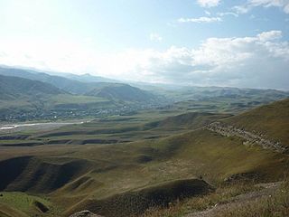
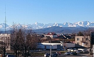
Tyrnyauz is a town and the administrative center of Elbrussky District of the Kabardino-Balkar Republic, Russia, located on the main road leading to the Upper Baksan valley area and on the main climbing route for Mount Elbrus. Population: 21,000 (2010 Census). Tyrnyauz is the largest town in the Baksan Valley and an essential provisioning point for trips into the Elbrus region.
Prokhladny is a town in the Kabardino-Balkar Republic, Russia, located on the Malka River, 60 kilometers (37 mi) north of Nalchik. Population: 59,601 (2010 Census); 61,772 (2002 Census); 57,084 (1989 Census).
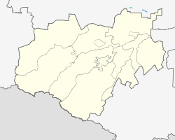
Baksansky District is an administrative and a municipal district (raion), one of the ten in the Kabardino-Balkar Republic, Russia. It is located in the north of the republic. The area of the district is 829.58 square kilometers (320.30 sq mi). Its administrative center is the town of Baksan. As of the 2010 Census, the total population of the district was 60,970.

Chegemsky District is an administrative and a municipal district (raion), one of the ten in the Kabardino-Balkar Republic, Russia. It is located in the central and southwestern parts of the republic. The area of the district is 1,503.32 square kilometers (580.44 sq mi). Its administrative center is the town of Chegem. As of the 2010 Census, the total population of the district was 69,092, with the population of Chegem accounting for 26.1% of that number.

Chereksky District is an administrative and a municipal district (raion), one of the ten in the Kabardino-Balkar Republic, Russia. It is located in the central and southern parts of the republic. The area of the district is 2,210 square kilometers (850 sq mi). Its administrative center is the rural locality of Kashkhatau. As of the 2010 Census, the total population of the district was 26,956, with the population of Kashkhatau accounting for 19.6% of that number.

Elbrussky District is an administrative and a municipal district (raion), one of the ten in the Kabardino-Balkar Republic, Russia. It is located in the western and southwestern parts of the republic. The area of the district is 1,850.43 square kilometers (714.46 sq mi). Its administrative center is the town of Tyrnyauz. As of the 2010 Census, the total population of the district was 36,260, with the population of Tyrnyauz accounting for 57.9% of that number.
Leskensky District is an administrative and a municipal district (raion), one of the ten in the Kabardino-Balkar Republic, Russia. It is located in the southeast of the republic. The area of the district is 523.06 square kilometers (201.95 sq mi). Its administrative center is the rural locality of Anzorey. As of the 2010 Census, the total population of the district was 27,840, with the population of Anzorey accounting for 23.5% of that number.
Maysky District is an administrative and a municipal district (raion), one of the ten in the Kabardino-Balkar Republic, Russia. It is located in the east of the republic. The area of the district is 384.76 square kilometers (148.56 sq mi). Its administrative center is the town of Maysky. As of the 2010 Census, the total population of the district was 38,625, with the population of the administrative center accounting for 69.3% of that number.

Prokhladnensky District is an administrative and a municipal district (raion), one of the ten in the Kabardino-Balkar Republic, Russia. It is located in the northeast of the republic. The area of the district is 1,342 square kilometers (518 sq mi). Its administrative center is the town of Prokhladny. As of the 2010 Census, the total population of the district was 45,533.

Urvansky District is an administrative and a municipal district (raion), one of the ten in the Kabardino-Balkar Republic, Russia. It is located in the east of the republic. The area of the district is 458 square kilometers (177 sq mi). Its administrative center is the town of Nartkala. As of the 2010 Census, the total population of the district was 71,782, with the population of Nartkala accounting for 44.2% of that number.
Zolsky District is an administrative and a municipal district (raion), one of the ten in the Kabardino-Balkar Republic, Russia. It is located in the western and northwestern parts of the republic. The area of the district is 2,124 square kilometers (820 sq mi). Its administrative center is the rural locality of Zalukokoazhe. As of the 2010 Census, the total population of the district was 48,939, with the population of Zalukokoazhe accounting for 20.1% of that number.

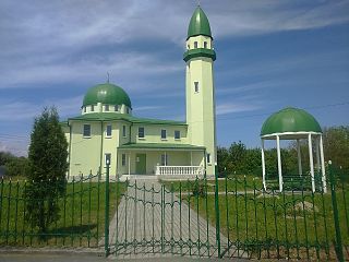
Baksan is a town in the Kabardino-Balkar Republic, Russia, located 24 kilometers (15 mi) northwest of Nalchik on the left bank of the Baksan River. Population: 36,860 (2010 Census); 35,805 (2002 Census); 28,767 (1989 Census).
Chegem is a town and the administrative center of Chegemsky District of the Kabardino-Balkar Republic, Russia, located 10 kilometers (6.2 mi) north of Nalchik, at the elevation of about 470 meters (1,540 ft). Population: 18,019 (2010 Census).

Maysky is a town and the administrative center of Maysky District of the Kabardino-Balkar Republic, Russia, located 40 kilometers (25 mi) northeast of Nalchik, the capital of the republic. Population: 26,755 (2010 Census).

Nartkala is a town and the administrative center of Urvansky District of the Kabardino-Balkar Republic, Russia, located 25 kilometers (16 mi) northeast of Nalchik. Population: 31,694 (2010 Census).

Anzorey is a rural locality and the administrative center of Leskensky District of the Kabardino-Balkar Republic, Russia. Population: 6,551 (2010 Census); 6,931 (2002 Census);
Kashkhatau is a rural locality and the administrative center of Chereksky District of the Kabardino-Balkar Republic, Russia. Population: 5,295 (2010 Census); 5,211 (2002 Census); 4,412 (1989 Census).
Zalukokoazhe is a rural locality and the administrative center of Zolsky District of the Kabardino-Balkar Republic, Russia. Population: 9,859 (2010 Census); 9,276 (2002 Census); 6,110 (1989 Census).