
Highway 22 is an east–west state highway in the Arkansas River Valley. It is maintained by the Arkansas State Highway and Transportation Department (AHTD). The highway runs 75.60 miles (121.67 km) from US 64/US 71B east to Highway 7 in Dardanelle. Following the historic stagecoach line of the cross-country Butterfield Trail, the highway is one of the original 1926 state highways. It is designated by the AHTD as the True Grit Trail.
This is a list of properties and historic districts in Arkansas that are listed on the National Register of Historic Places. There are more than 2,600 listings in the state, including at least 8 listings in each of Arkansas's 75 counties.
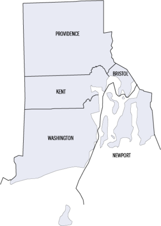
This is a list of properties and districts listed on the National Register of Historic Places in Rhode Island. As of May 29, 2015, there are more than 750 listed sites in Rhode Island. All 5 of the counties in Rhode Island have listings on the National Register.

This is a list of the National Register of Historic Places listings in Providence County, Rhode Island.

This is a list of the National Register of Historic Places listings in Providence, Rhode Island.

U.S. Route 64 is a U.S. highway running from Teec Nos Pos, Arizona east to Nags Head, North Carolina. In the U.S. state of Arkansas, the route runs 246.35 miles (396.46 km) from the Oklahoma border in Fort Smith east to the Tennessee border in Memphis. The route passes through several cities and towns, including Fort Smith, Clarksville, Russellville, Conway, Searcy, and West Memphis. US 64 runs parallel to Interstate 40 until Conway, when I-40 takes a more southerly route.
Providence is an unincorporated community in Cecil County, Maryland, United States. Hopewell and Little Elk Farm were listed on the National Register of Historic Places in 1979.

Highway 157 is a designation for two state highways in Northeast Arkansas. One segment begins at Highway 367 in Judsonia and runs north to Highway 14 near Oil Trough. A second, short industrial access road also carries the Highway 157 designation in Diaz. Both routes are maintained by the Arkansas Department of Transportation (ArDOT).

This is a list of the National Register of Historic Places listings in Benton County, Arkansas.

This is a list of the National Register of Historic Places listings in Hempstead County, Arkansas.

This is a list of the National Register of Historic Places listings in Mississippi County, Arkansas.

This is a list of the National Register of Historic Places listings in White County, Arkansas.

This is a list of the National Register of Historic Places listings in Little Rock, Arkansas.
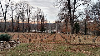
Fayetteville Confederate Cemetery is a cemetery for soldiers of the Confederate States located on the eastern side of Fayetteville in Washington County, Arkansas. Added to the National Register of Historic Places (NRHP) in 1993, the cemetery encompasses 3.5 acres (1.4 ha).
The J. C. Rhew Co. Packing Shed was a strawberry packing house in rural northern White County, Arkansas. It was located on the south side of Graham Road near its junction with Fuller Road, northeast of Providence. It was a single-story wood-frame structure, in the shape of a long rectangle divided into six bays, capped by a gable roof and set on concrete piers. Built about 1939, it was noted for a distinctive floor plan, apparently designed to facilitate the movement of workers through the building.
The National Register Information System (NRIS) is a database of properties that have been listed on the United States National Register of Historic Places. The database includes more than 84,000 entries of historic sites that are currently listed on the National Register, that were previously listed and later removed, or that are pending listing. The database includes approximately 45 pieces of data for each listed property. Accuracy of the NRIS database may be imperfect. For example, a 2004 paper addressed accuracy of spatial location data for part of the NRIS content.

U.S. Highway 71 is a U.S. highway that runs from Krotz Springs, LA to the Fort Frances–International Falls International Bridge at the Canadian border. In Arkansas, the highway runs from the Louisiana state line near Doddridge to the Missouri state line near Bella Vista. In Texarkana, the highway runs along State Line Avenue with US 59 and partially runs in Texas. Other areas served by the highway include Fort Smith and Northwest Arkansas.
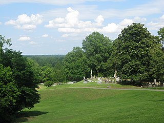
The Helena Confederate Cemetery is located in the southwest corner of the Maple Hill Cemetery on Holly Street in Helena, Arkansas. It is a small section of the larger cemetery, under one acre in size, and is marked by two significant memorials: the Confederate Memorial and the memorial to Confederate Army General Patrick Cleburne, whose burial here is the only known place associated with his life. The Cleburne memorial is a marble shaft 15 feet (4.6 m) in height, topped by an urn with flames coming from its top. The Confederate Memorial is a marble depiction of a soldier, mounted on a 30-foot (9.1 m) granite shaft, surrounded by pyramids of cannonballs and inverted cannons. The cemetery has more than 100 marked graves, 15 of which are unidentified Confederate dead, and 23 are of those killed in the 1863 Battle of Helena.

Highway 51 is a designation for two north–south state highways in Southwest Arkansas. One route of 53.37 miles (85.89 km) begins Highway 53 near Whelen Springs and runs north to US Highway 67 in Donaldson. A second route of 7.92 miles (12.75 km) runs parallel to US 270 northwest of Malvern. Both routes are maintained by the Arkansas Department of Transportation (ArDOT).


