Providence, Warren and Bristol Railroad

Last updated
Providence, Warren, and Bristol Railroad
Providence, Warren and Bristol Railroad
System map, 1918
Old Colony Riverside train station.jpg
The former Riverside train station still stands next to the former tracks, which are now the East Bay Bicycle Path
Overview
Stations called at21
Parent company Boston & Providence Railroad, Old Colony Railroad
Reporting mark PW&B
Locale Bristol County, Rhode Island,

Providence County, Rhode Island,

East Bay (Rhode Island)
Dates of operation18551888 (Independent operations), 1888-1893 (Old Colony Railroad), 1893-1969 (New York, New Haven, and Hartford Railroad), 1969-1976 (Penn Central), 1976-2006 (Providence & Worcester Railroad)
Successors
Technical
Track gauge 4 ft 8+12 in (1,435 mm) standard gauge
Electrification Overhead line,  600 V DC (electrified 1900-1934)
Track length14.1 miles (22.7 kilometers)

The Providence, Warren and Bristol Railroad (also known as the Bristol Secondary) was a railroad in the state of Rhode Island that connected the city of Providence with Bristol, Rhode Island. The company was formed in 1854 by merging the Providence, Warren and Bristol Railroad Companies of Massachusetts and Rhode Island. The 14.1-mile line itself was completed on July 12, 1855. [1]

Contents

Most of the line south of East Providence was abandoned in 1976; all rail operations ceased on the remainder of the line in 2006. The former right-of-way has since been converted into the East Bay Bike Path.

History

The Boston and Providence Railroad originally terminated their 1835 mainline at India Point on an alignment that presently exists as the East Junction Branch; this line became a branch in 1847 with the opening of the new B&P mainline from East Junction to Providence. In 1848, Union Station opened in the center of Providence; it became the Boston & Providence's main terminal and the facilities along the harbor were used thereafter mainly for freight. The Boston & Bristol Railroad received a charter in 1850 to construct a railroad from East Providence to Bristol via Warren. In 1855, the newly renamed Providence, Warren and Bristol Railroad opened as a Bristol extension of the India Point Branch along the eastern bank of the Seekonk River. Initially, passenger cars were hauled by horse to the Providence & Worcester depot until 1857, when the PW&B built its own depot on India Street. [2]

The B&P had initially operated the line until 1860, when the PW&B started using their own locomotives. The line had originally crossed state boundaries when it had first opened; a portion of the line ran through the town of Seekonk, Massachusetts. The area of Seekonk that banked the Seekonk River was reincorporated as East Providence, Rhode Island as part of a boundary settlement between the two states in 1862; this positioned the PW&B right-of-way entirely within the boundary of Rhode Island.

In 1865, the Fall River, Warren and Providence Railroad built a western branch off the PW&B line at a junction in Warren. Initially, the branch ran from Warren to Brayton Point in Somerset, Massachusetts, which required a ferry transfer to Fall River. The ferry transfer lasted until 1875 when the Slades Ferry Bridge was constructed which allowed trains to cross the Taunton River into Fall River Depot. The two lines were related to the Boston & Providence and Old Colony Railroad, their connections at East Providence and Fall River, respectively. Full ownership of each line was acquired in 1872 by the Boston & Providence which subsequently sold the Fall River Branch to the Old Colony the next year. [3]

Operations under Old Colony and NYNH&H

In 1888 the Old Colony leased the B&P and thereby put the two "Warren" lines under one management.  On July 1, 1891, the line was leased to the Old Colony Railroad for 99 years. [4] Later in 1893, the PW&B was absorbed into the New York, New Haven and Hartford Railroad, upon its lease of the Old Colony Railroad system. During this time, PW&B trains reached a Providence depot near Fox Point using the B&P's India Point bridge.

Providence's Union Station was located just west of the PW&B's northern terminus. Attempts were made to run full size freight cars over the trolley tracks to Union Station, which resulted in frequent derailments. This issue prompted the construction of the Crook Point Bascule Bridge along with a mile-long tunnel under Providence’s east side known as the East Side Railroad Tunnel; both the tunnel, bridge, and a 1,000 foot-long (304.8 m) downtown viaduct were completed in 1908. [5]

1902 map of route electrification 1902 map of Providence, Warren and Bristol Branch electrification.jpg
1902 map of route electrification

Electrification

Under the New Haven, the PW&B and the Fall River Branch were one of the few electrified heavy-rail lines in New England outside of Massachusetts and Connecticut during the early twentieth century. The New Haven electrified both lines in 1900; the overhead was a standard 600 Volt DC single-wire trolley system. Former locomotive-hauled coaches were converted into self-propelled cars which used trolley poles as opposed to pantographs. [5] Due to the high frequency of the route (headways were projected to be eight to ten minutes at peak times), the line could be considered the only rapid transit service to ever exist in Rhode Island.

To handle peak rush-hour power demands, two battery stations were built close to the Providence & Fall River ends of the line; off-peak, the batteries were "float-charged" by the power plant in Warren. During rush hour periods, the battery stations would pick up some of the load, easing the burden on the powerhouse. Under electrification, the line operated similarly to an interurban service with the unique distinction that it utilized full-size heavy-rail equipment. [5] Freight services were still operated by steam locomotives after the line was electrified.

Route

The PW&B's northern terminus was at India Point, where it branched from the B&P East Junction Branch; this junction formed a wye on the east side of the Seekonk River, with the southern leg being the PW&B mainline. After the construction of the East Side Tunnel, all Bristol and Fall River services originated from Providence Union Station. The line then ran through East Providence then through Riverside, Barrington, and Warren with double track between Providence and Warren, a distance of 10 miles (16.1 km). In Warren, the line split into two single-track branches; one going east to Fall River via the Slade's Ferry swing bridge, the other to the railroad's southern terminus at Bristol, Rhode Island. [5] Select Bristol-bound trains street-ran on streetcar trackage to reach Church Street and Constitution Street beyond the Bristol terminal station.

Decline

Abandoned Crook Point Bascule Bridge; notice the catenary structures on the span Crook Point Bascule Bridge, May 2017.JPG
Abandoned Crook Point Bascule Bridge; notice the catenary structures on the span

Although the line was well patronized and service was frequent for many years, growing automobile ownership and the steady reduction of industry in East Bay during the Great Depression doomed the line. Passenger service to Fall River ceased after a ship struck and caused irreparable damage to the Slade’s Ferry Bridge in 1932; the bridge was converted for automobile traffic only and the line was truncated back to Brayton Point in Somerset. That same year, all passenger service and through freight service ended south of Weir Junction on the Dighton and Somerset mainline when the swing bridge located at Mallard Point, located roughly 4 miles (6.4 km) north of the Slade's Ferry Bridge, was disabled after a ship hit another bridge carrying power cables; this combined with the truncation of the Fall River branch effectively eliminated all east-west mainline rail connections to Fall River. Electrified passenger service was cut-back before being entirely ceased on the Bristol line in 1934; passenger service was switched over to gas-electric cars until being entirely ceased by 1937, after which the line was used exclusively for freight. [5] That same year, freight service on the Fall River Branch ceased when the entire branch was abandoned, with the exception of the first half-mile between Warren and East Warren which was retained as a stub.

Freight and excursion services continued on the Bristol line for the next three decades. NYNH&H successor Penn Central took control of the line in 1969, which abandoned the Warren-to-Bristol segment in 1973; the remaining segment only saw freight service once or twice per week involving consists no longer than four cars per train. Conrail inherited the line from PC in 1976 which abandoned the rest of the line south of Pomham in Riverside. The newly independent Providence and Worcester Railroad assumed operations of line the same year and further truncated the line to Bold Point in East Providence. [2] The Crook Point Bascule Bridge and the East Side Tunnel were acquired by the state of Rhode Island in 1981 and all rail operations ceased shortly thereafter; the downtown Providence viaduct was demolished when the Northeast Corridor was re-routed to facilitate remodeling of the downtown area in Providence in the early 1980s. In the present day, the Crook Point Bridge and East Side Tunnel remain abandoned and isolated from any active rail lines.

Freight continued to service a scrapyard at Wilkesbarre Pier until the early 2000s; by 2006, the portion between India Point and Pomham had been legally abandoned by the P&W. [6]

Commuter rail proposals

Before the line’s full abandonment, the Rhode Island Department of Transportation briefly considered restoring passenger service to the PW&B right-of-way as a state-subsidized commuter rail line within a 1981 transit study that evaluated options to realign the Northeast Corridor. [7] The commuter line, referred within the study as East Side Rail Transit, would have operated commuter trains between Providence Union Station and Bristol via the East Side Tunnel. Proposed intermediate stations were East Providence, West Barrington, Barrington and Warren. In Providence, the East Side line would have met another proposed commuter line operating between Providence and Davisville along the Northeast Corridor. The study also proposed other alternatives such as a shorter East Side light rail alignment. [8] RIDOT demolished the downtown Providence viaduct during the re-routing of the Northeast Corridor later in the 1980s; this permanently severed the East Side Tunnel from the Northeast Corridor and precluded the option for the future implementation of commuter rail or light rail.

The restoration of passenger rail on the Bristol Secondary was studied in 1994 as a part of a larger state rail corridor feasibility study. The purpose of the study was to determine the potential for the use of the existing or rail-banked railroad rights-of-way for public transportation facilities and services. [9] Restoration of the Bristol Secondary for commuter rail service was evaluated to cost $72.72 million with a total annual operating cost of $13.92 million; it was estimated the line would attract 2,900-4,300 daily riders. The study acknowledged that rail restoration to Bristol would need to accommodate the existing rail-trail; the proposed routing included the East Junction Branch between Attleboro and East Providence. Another proposal indicated the construction of a new rail bridge across Mount Hope Bay to connect the Bristol Secondary to the Newport Secondary; light rail alternatives were also considered for the line. [9] Ultimately, none of the rail service proposals from the 1994 study were funded or approved.

Conversion to rail trail

In 1992, most of the PW&B right-of-way opened as the East Bay Bike Path. In areas where the right-of-way was double tracked, the bike path occupies one of the main lines; the parallel main line and remaining trackage are occasionally visible running alongside the paved bikeway. The track passes the original station in Riverside, which is now used as a café.

The Crook Point Bascule Bridge permanently remains in an open up-right position; the catenary structures on the bridge span remain one of the only remnants of the line’s former electrification. The East Side Tunnel portals have since been sealed.  Multiple proposals have since been made to repurpose the tunnel and bridge as part of a BRT or light-rail line. [6] A more recent plan in 2021 involved converting the area around the bridge into a park; however, that plan has since been subsequently abandoned. [10]

Station list

LocationStation Miles (km) ImageNotes
Providence Providence (India Point before 1908)0.0

(0.0)

MAIN TERMINAL BUILDING, LOOKING NORTHEAST - Providence Union Station, Exchange Terrace, Providence, Providence County, RI HABS RI,4-PROV,177-5.tif Later relocated to Providence Union Station with opening of East Side Railroad Tunnel in 1908
East Providence East Providence (India Point)2.0

(3.2)

East Providence station 1913 postcard.jpg Junction with India Point Branch [11]
Gulf3.5

(5.6)

Kettle Point4.0

(6.4)

Squantum4.5

(7.2)

Boyden Heights station and Squantum Club postcard.jpg
Silver Spring5.0

(8.0)

Union Club5.3

(8.5)

Pomham5.5

(8.9)

Riverside6

(9.6)

Riverside (RI) station postcard.jpg Station structure still extant
Bullocks Point6.5

(10.5)

Bullocks Point Railroad Station Barrington RI.png
Barrington Drownsville (Crescent Park)7

(12.1)

West Barrington7.5

(12.1)

Nyatt8.5

(13.7)

Barrington10

(16.1)

Barrington station postcard.jpg
Hampden Meadows10.5

(16.9)

Warren North Warren11

(17.7)

Warren11.5

(18.5)

Warren station 1911 postcard.jpg Junction with Warren-Fall River branch
South Warren12

(19.3)

Bristol Beach Terrace13.5

(21.7)

Bristol Highlands14

(22.5)

Poppasquash Road15

(24.1)

Bristol16

(25.7)

Bristol Constitution Street station postcard.jpg

See also

Related Research Articles

<span class="mw-page-title-main">Northeast Corridor</span> Electrified railroad line in the Northeastern U.S.

The Northeast Corridor (NEC) is an electrified railroad line in the Northeast megalopolis of the United States. Owned primarily by Amtrak, it runs from Boston in the north to Washington, D.C. in the south, with major stops in Providence, New Haven, Stamford, New York City, Newark, Trenton, Philadelphia, Wilmington, and Baltimore. The NEC closely parallels Interstate 95 for most of its length. Carrying more than 2,200 trains a day, it is the busiest passenger rail line in the United States by ridership and by service frequency.

<span class="mw-page-title-main">New York Connecting Railroad</span> Freight rail line in New York City

The New York Connecting Railroad or NYCR is a rail line in the borough of Queens in New York City. It links New York City and Long Island by rail directly to the North American mainland. Amtrak, CSX, Canadian Pacific Kansas City, Providence and Worcester Railroad and New York and Atlantic Railway (NYAR) currently use the line. It runs from the Hell Gate Bridge over the East River to Fresh Pond Junction yard in Glendale in Queens. It was completed in 1917. Amtrak uses the northernmost section of the line from Sunnyside Junction in the Woodside section of Queens to the Hell Gate Bridge into the Bronx from which it follows the line north to Boston.

<span class="mw-page-title-main">MBTA Commuter Rail</span> Greater Boston commuter rail system

The MBTA Commuter Rail system serves as the commuter rail arm of the Massachusetts Bay Transportation Authority's (MBTA's) transportation coverage of Greater Boston in the United States. Trains run over 394 mi (634 km) of track to 134 stations. It is operated under contract by Keolis, which took over operations on July 1, 2014, from the Massachusetts Bay Commuter Railroad Company (MBCR).

<span class="mw-page-title-main">Providence and Worcester Railroad</span> Regional railroad in the Northeastern United States

The Providence and Worcester Railroad is a Class II railroad operating 612 miles (985 km) of tracks in Rhode Island, Massachusetts, and Connecticut, as well as New York via trackage rights. The company was founded in 1844 to build a railroad between Providence, Rhode Island, and Worcester, Massachusetts, and ran its first trains in 1847. A successful railroad, the P&W subsequently expanded with a branch to East Providence, Rhode Island, and for a time leased two small Massachusetts railroads. Originally a single track, its busy mainline was double-tracked after a fatal 1853 collision in Valley Falls, Rhode Island.

<span class="mw-page-title-main">Old Colony Railroad</span> Former railroad system in Massachusetts and Rhode Island

The Old Colony Railroad (OC) was a major railroad system, mainly covering southeastern Massachusetts and parts of Rhode Island, which operated from 1845 to 1893. Old Colony trains ran from Boston to points such as Plymouth, Fall River, New Bedford, Newport, Providence, Fitchburg, Lowell and Cape Cod. For many years the Old Colony Railroad Company also operated steamboat and ferry lines, including those of the Fall River Line with express train service from Boston to its wharf in Fall River where passengers boarded luxury liners to New York City. The company also briefly operated a railroad line on Martha's Vineyard, as well as the freight-only Union Freight Railroad in Boston. The OC was named after the "Old Colony", the nickname for the Plymouth Colony.

<span class="mw-page-title-main">New York and New England Railroad</span> Defunct railroad in southern New England

The New York and New England Railroad (NY&NE) was a railroad connecting southern New York State with Hartford, Connecticut; Providence, Rhode Island; and Boston, Massachusetts. It operated under that name from 1873 to 1893. Prior to 1873 it was known as the Boston, Hartford and Erie Railroad, which had been formed from several smaller railroads that dated back to 1846. After a bankruptcy in 1893, the NY&NE was reorganized and briefly operated as the New England Railroad before being leased to the competing New York, New Haven and Hartford Railroad in 1898.

<span class="mw-page-title-main">Boston and Providence Railroad</span> Former railroad company operating in Massachusetts and Rhode Island

The Boston and Providence Railroad was a railroad company in the states of Massachusetts and Rhode Island which connected its namesake cities. It opened in two sections in 1834 and 1835 - one of the first rail lines in the United States - with a more direct route into Providence built in 1847. Branches were built to Dedham in 1834, Stoughton in 1845, and North Attleboro in 1871. It was acquired by the Old Colony Railroad in 1888, which in turn was leased by the New Haven Railroad in 1893. The line became the New Haven's primary mainline to Boston; it was realigned in Boston in 1899 during the construction of South Station, and in Pawtucket and Central Falls in 1916 for grade crossing elimination.

The Baltimore and Philadelphia Railroad was a railroad line built by the Baltimore and Ohio Railroad (B&O) from Philadelphia, Pennsylvania, to the Maryland-Delaware state line, where it connected with the B&O's Philadelphia Branch to reach Baltimore, Maryland. It was built in the 1880s after the B&O lost access to its previous route to Philadelphia, the Philadelphia, Wilmington and Baltimore Railroad (PW&B). The cost of building the new route, especially the Howard Street Tunnel on the connecting Baltimore Belt Line, led to the B&O's first bankruptcy. Today, the line is used by CSX Transportation for freight trains.

<span class="mw-page-title-main">New York, Providence and Boston Railroad</span> New York, New Haven and Hartford Railroad subsidiary

The New York, Providence and Boston Railroad, normally called the Stonington Line, was a major part of the New York, New Haven and Hartford Railroad between New London, Connecticut and Providence, Rhode Island. It is now part of Amtrak's high-speed Northeast Corridor.

<span class="mw-page-title-main">East Side Railroad Tunnel</span> Former railroad tunnel in Rhode Island

The East Side Railroad Tunnel is a former railroad tunnel that runs underneath the East Side of Providence, Rhode Island. The tunnel runs 5,080 feet (1,550 m), under College Hill, from Gano Street to just west of Benefit Street. It was opened on November 16, 1908, at a cost of $2 million. All rail service ceased through the tunnel in 1976 and has been abandoned since.

<span class="mw-page-title-main">Providence/Stoughton Line</span> Line of the Boston MBTA Commuter Rail system

The Providence/Stoughton Line is an MBTA Commuter Rail service in Massachusetts and Rhode Island, primarily serving the southwestern suburbs of Boston. Most service runs entirely on the Northeast Corridor between South Station in Boston and Providence station or Wickford Junction station in Rhode Island, while the Stoughton Branch splits at Canton Junction and terminates at Stoughton. It is the longest MBTA Commuter Rail line, and the only one that operates outside Massachusetts. The line is the busiest on the MBTA Commuter Rail system, with 17,648 daily boardings in an October 2022 count.

<span class="mw-page-title-main">East Junction Branch</span> Railroad line

The East Junction Branch is a rail line in Rhode Island and Massachusetts, in the United States. Originally built by the Boston and Providence Railroad (B&P) in 1835, the line connects Attleboro, Massachusetts, and East Providence, Rhode Island via Seekonk, Massachusetts. As built, the line continued across the Seekonk River to Providence via the India Point Railroad Bridge; this connection was removed during the 1970s. The East Junction Branch meets the Northeast Corridor in Attleboro at a point known as East Junction, and ends at a connection to the East Providence Branch in East Providence. CSX Transportation operates freight service on the branch in Attleboro, while the Providence and Worcester Railroad (P&W) operates freight service in East Providence and across the state line into Seekonk. The line is owned by the P&W in Rhode Island, and by the Massachusetts Bay Transportation Authority in Massachusetts.

<span class="mw-page-title-main">Providence metropolitan area</span> Metropolitan Statistical Area in the United States

The Providence metropolitan area is a region extending into eight counties in two states. Its core is in the states of Rhode Island and Massachusetts, and it is the 38th largest metropolitan area in the United States. The largest city in the Providence MSA is Providence, Rhode Island, with an estimated population of 1,622,520, exceeding that of Rhode Island by slightly over 60%. The MSA covers all of Rhode Island and Bristol County, Massachusetts, with an average population density of 2300 per mi2.

<span class="mw-page-title-main">East Bay Bike Path</span> Multi-use trail in Rhode Island

The East Bay Bike Path is a 14.5-mile (23.3 km) paved rail trail in Rhode Island. The path originates in Providence and India Point Park, crosses the Seekonk River via the George Redman Linear Park and the Washington Bridge, and continues southeast to Bristol along the shoreline of Narragansett Bay. The path passes through the city of East Providence, the hamlet of Riverside, and the towns of Barrington and Warren. It is part of the East Coast Greenway, a 3,000-mile system of trails connecting the Canada–US border in Maine to Key West, as well as provides access to Haines State Park, Brickyard Pond (Barrington), and Colt State Park.

<span class="mw-page-title-main">Boston and Providence Railroad Bridge</span> United States historic place

The Boston and Providence Railroad Bridge in East Providence is a railroad bridge on the East Junction Branch spanning Ten Mile River. A portion of the bridge also spans Roger Williams Avenue. The bridge was built in 1884 by the Boston and Providence Railroad, replacing an earlier structure on the line. The bridge abutments are faced in coursed ashlar stone, with brick-faced segmental-arch tunnels piercing them. The main span of the bridge consists of two Warren trusses resting on the abutments and a central pier in the Ten Mile River. The bridge formerly carried two tracks, but has been reduced to one.

<span class="mw-page-title-main">Crook Point Bascule Bridge</span> Bridge in between Providence and East Providence

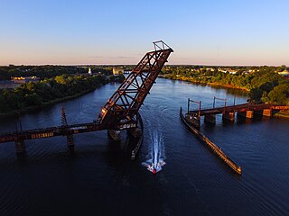
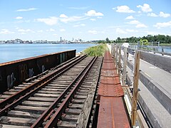
The Crook Point Bascule Bridge is a defunct Scherzer rolling lift railway bridge which spans the Seekonk River, connecting the city of Providence, Rhode Island, to the city of East Providence. Stuck in the open position since its abandonment in 1976, it is known to nearby residents as the "Stuck-Up Bridge" and has become somewhat of a local icon of urban decay.

<span class="mw-page-title-main">Fall River, Warren and Providence Railroad</span> Defunct railroad branch in Massachusetts and Rhode Island

The Fall River, Warren and Providence Railroad was a branch of the Providence, Warren and Bristol Railroad that ran through the states of Rhode Island and Southeastern Massachusetts. The 8-mile (12.9 km) railroad branch formerly connected the city of Fall River, Massachusetts and Providence, Rhode Island via Warren, Rhode Island.

<span class="mw-page-title-main">Moshassuck Valley Railroad</span> Defunct railroad in Rhode Island

The Moshassuck Valley Railroad, founded in 1874, was a shortline railroad in Rhode Island, United States. Built from 1876 to 1877, it operated on a 2-mile (3.2 km) long line between Lincoln and a connection to the Providence and Worcester and Boston and Providence railroads, both of which were subsequently purchased by the New York, New Haven and Hartford Railroad, in the Woodlawn neighborhood of Pawtucket. The company was formed by the Sayles brothers, owners of a significant mill in Saylesville near the line's terminus. Freight was the primary traffic of the railroad, but frequent passenger service was also provided by a self-propelled steam passenger car until 1921.

<span class="mw-page-title-main">East Providence Branch</span> Rail line in Rhode Island and Massachusetts

The East Providence Branch is a railroad line in Rhode Island and Massachusetts, in the United States. It connects Valley Falls, Rhode Island, to East Providence, Rhode Island, via South Attleboro, Massachusetts, and Pawtucket, Rhode Island. The branch was originally built by the Providence and Worcester Railroad (P&W) in 1874, connecting its main line to a coal dock in East Providence, and was 7 miles (11 km) in length. At East Providence, the branch also met the East Junction Branch of the Boston and Providence Railroad and the mainline of the Providence, Warren and Bristol Railroad. Built as a single-track railroad with bridges and the right-of-way prepared for future double-tracking, the line was fully double-tracked from 1892 to 1895; the second track was eventually removed.

References

  1. Report of the Board of Railroad Commissioners, February 15, 1911, page 428
  2. 1 2 Karr, Ronald Dale (2017). The Rail Lines of Southern New England (2nd ed.). Pepperell, Massachusetts: Branch Line Press. pp. 165–169, 175–183. ISBN   978-0-942147-12-4. OCLC   1038017689. Archived from the original on 2021-10-24. Retrieved 2021-10-22.
  3. "RHODE ISLAND RAILROADS - PW&B ROUTE". sites.google.com. Retrieved 2022-11-05.
  4. The Story of the Old Colony Railroad, 1919
  5. 1 2 3 4 5 "The Providence, Warren and Bristol Railroad - Abandoned Rails". www.abandonedrails.com. Retrieved 2022-11-05.
  6. 1 2 Dujardin, Richard. "Visions of a new East Providence waterfront". 13 July 2003
  7. Providence Railroad and Highway Improvements, Northeast Corridor Improvement Project: Environmental Impact Statement. United States: n.p., 1981. pg. 40
  8. Providence Railroad and Highway Improvements, Northeast Corridor Improvement Project: Environmental Impact Statement. United States: n.p., 1981. pg. 107
  9. 1 2 Boffi, Dante. "Rhode Island Department of Transportation Rail Corridor Feasibility Study- Executive Summary". RIDOT, November 1994
  10. Richard, Barry. "The Future of Rhode Island's Landmark Crook Point Bascule Bridge Remains Uncertain". 1420 WBSM. Retrieved 2022-11-05.
  11. Providence County Atlas, 1895
Template:Attached KML/Providence, Warren and Bristol Railroad
KML is not from Wikidata

Commons-logo.svg Media related to Providence, Warren and Bristol Railroad at Wikimedia Commons