List of Old Colony Railroad stations

Last updated

Map of OCRR lines, 1893 OC1893.jpg
Map of OCRR lines, 1893

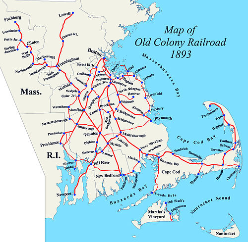
The following is a list of historic Old Colony Railroad (OCRR) stations, at the time of the 1893 lease by the New York, New Haven and Hartford Railroad and shortly after. [1] City/town include current town name, some of which were incorporated after 1893. Stations currently used by the Massachusetts Bay Transportation Authority or Amtrak are indicated within the notes column.

Contents

All stations are located in the state of Massachusetts unless otherwise noted.

Central Division

Boston to Plymouth

LocationStation Miles (km) ImageNotes
Boston Boston0.0 (0.0) Woodcutting of Old Colony Railroad terminal, 1875.jpg Boston terminus moved from Kneeland Street to South Station in 1899
South Boston0.7 (1.1) South Boston station 1913.jpg
Crescent Avenue 2.4 (3.9) Moving Crescent station, October 1926.jpg Present location of JFK/UMass station on the Red Line, Greenbush Line, Kingston Line, and Middleborough/Lakeville Line
Savin Hill 3.0 (4.8) Northerly view, Savin Hill Avenue Station, No. 174.jpg Present location of Savin Hill station on the Red Line
Harrison Square3.6 (5.8) Suburban homes on the "Old Colony." A directory for those who seek a suburban residence (1889) (14738154136).jpg Junction with Shawmut Branch
Popes Hill4.3 (6.9)
Neponset4.9 (7.9) Neponset station 1914 postcard.jpg Junction with Dorchester and Milton Branch
Quincy Atlantic 5.5 (8.9) Atlantic station 1910 postcard.jpg Junction with Granite Branch
Norfolk Downs 6.1 (9.8) Norfolk Downs station 1912 postcard.jpg
Wollaston Heights 6.7 (10.8) Wollaston station postcard (4).jpg Present location of Wollaston station on the Red Line
Quincy 8.0 (12.9) Quincy station on 1911 postcard.jpg Present location of Quincy Center on the Red Line, Greenbush Line, Kingston Line, and Middleborough/Lakeville Line
Quincy Adams 8.7 (14.0)Originally named South Quincy
Present location of Quincy Adams station on the Red Line
Braintree Braintree 10.1 (16.3) Old Colony Braintree station.JPG Junction with South Shore Branch
South Braintree 11.4 (18.3) South Braintree station 1907 postcard.jpg Junction with Middleborough-Fall River main line
Weymouth South Weymouth 14.9 (24.0) Former South Weymouth station building, November 2016.JPG
Abington North Abington 17.8 (28.6) North Abington Depot.jpg Junction with Hanover Branch
Abington 19.2 (30.9) Abington station postcard.jpg Present location of Abington station on the Kingston Line
Whitman Whitman 21.1 (34.0) Whitman station postcard.jpg Junction with East Bridgewater Branch
Present location of Halifax station on the Kingston Line
Hanson North Hanson23.1 (37.2)
South Hanson 24.6 (39.6) South Hanson Station, South Hanson MA.jpg Present location of Hanson station on the Kingston Line
Burrage26.2 (42.2)Also called Bournetown
Monponsett27.1 (43.6)
Halifax Halifax 28.4 (45.7)Present location of Halifax station on the Kingston Line
Kingston Silver Lake29.9 (48.1)Also called Plympton
Kingston 33.3 (53.6) Solstice, Kingston MA.jpg Junction with South Shore Branch
Plymouth Cordage 35.4 (57.0) Seaside station 1915 postcard.jpg Originally named North Plymouth and later Seaside
Present location of Plymouth station on the Kingston Line
Plymouth 37.4 (60.2) Plymouth station postcard.jpg Junction with Plymouth and Middleborough Branch

Shawmut Branch

LocationStation Miles (km) ImageNotes
Boston Harrison Square3.6 (5.8) Suburban homes on the "Old Colony." A directory for those who seek a suburban residence (1889) (14738154136).jpg Junction with Boston-Plymouth main line
Fields Corner 4.0 (6.4) Fields Corner station, February 1926.jpg Present location of Fields Corner station on the Red Line
Shawmut 4.6 (7.4) Westerly exposure to Shawmut Railroad Station, March 1926.jpg Consolidated from stations at Melville Avenue and Centre Street in 1884
Present location of Shawmut station on the Red Line
Ashmont 5.2 (8.4) Ashmont Station, No. 220.jpg Present location of Ashmont station on the Red Line and Mattapan Trolley
Cedar Grove5.6 (9.0) Cedar Grove Station, No. 309.jpg Present location of Cedar Grove station on the Mattapan Trolley
Milton Milton 6.4 (10.3) Milton station before being razed, April 1929.jpg Junction with Dorchester and Milton Branch
Previously named Milton Lower Mills
Present location of Milton station on the Mattapan Trolley

Dorchester and Milton Branch

LocationStation Miles (km) ImageNotes
Boston Neponset4.9 (7.9) Neponset station 1914 postcard.jpg Junction with Boston-Plymouth main line
Granite Bridge5.9 (9.5)
Milton Milton 6.8 (10.9) Milton station before being razed, April 1929.jpg Junction with Shawmut Branch
Previously named Milton Lower Mills and Milton Mills
Present location of Milton station on the Mattapan Trolley
Central Avenue 7.1 (11.4) Central Avenue Railroad Station (16272505642).jpg Present location of Central Avenue station on the Mattapan Trolley
Boston Mattapan 8.1 (13.0) Mattapan Railroad Station (16085954470).jpg Present location of Mattapan station on the Mattapan Trolley

Granite Branch

LocationStation Mile (km) ImageNotes
Quincy Atlantic5.5 (8.9) Atlantic station 1910 postcard.jpg Junction with Boston-Plymouth main line
Montclair6.1 (9.8)
Milton East Milton7.5 (12.1) East Milton station postcard.jpg
Quincy West Quincy8.6 (13.8) West Quincy station postcard.jpg

South Shore Branch

LocationStation Mile (km) ImageNotes
Braintree Braintree Old Colony Braintree station.JPG Junction with Boston-Plymouth main line
East Braintree East Braintree station postcard.jpg
Weymouth Weymouth Weymouth station postcard.jpg Now Weymouth Landing/East Braintree, served by Greenbush Line
Weymouth Heights North Weymouth station, 1889.jpg
East Weymouth East Weymouth station postcard.jpg Now served by Greenbush Line
Hingham West Hingham Now served by Greenbush Line
Hingham Hingham Square postcard.jpg
Old Colony House Junction with Nantasket Beach Branch; now Nantasket Junction, served by Greenbush Line
North Cohasset
Cohasset King Street
Cohasset
Beechwood
Scituate North Scituate North Scituate station 1912 postcard.JPG Now served by Greenbush Line
Egypt Egypt station postcard.jpg
Scituate Scituate station 1908 postcard.jpg
Greenbush Greenbush station postcard.jpg Now served by Greenbush Line
Marshfield East Marshfield Marshfield Hills station postcard.jpg
Sea View Sea View station 1896 postcard.jpg
Marshfield Centre
Marshfield Marshfield station postcard.jpg
Webster Place Webster Place (Green Harbor) station postcard.jpg
Duxbury Duxbury Duxbury station postcard.jpg
South Duxbury South Duxbury station postcard.jpg
Island Creek
Kingston Kingston Solstice, Kingston MA.jpg Junction with Boston-Plymouth main line

Nantasket Beach Branch

LocationStation Mile (km) ImageNotes
Hingham Old Colony House Junction with South Shore Branch; now Nantasket Junction, served by Greenbush Line
Hull Nantasket Nantasket station from the north, January 2017.JPG
Surfside
Irvington
Kenberma Kenberma station 1919 postcard.jpg
Strawberry Hill
Bay Side
Allerton Beacon Road (Allerton) station postcard.jpg
Windermere
Stony Beach
Hull
Pemberton

Hanover Branch

LocationStation Mile (km) ImageNotes
Abington North Abington North Abington Depot.jpg Junction with Boston-Plymouth main line; station building is now a restaurant
Rockland Rockland Rockland station postcard.jpg
Hanover West Hanover
South Hanover
Hanover Four Corners

Whitman to Bridgwater Junction

LocationStation Mile (km) ImageNotes
Whitman Whitman Whitman station postcard.jpg Junction with Boston-Plymouth main line; now served by Kingston/Plymouth Line
Washington Street
East Bridgewater Browns Station
East Bridgewater East Bridgewater station postcard.jpg
Elmwood Elmwood station 1910 postcard.jpg
West Bridgewater WestdaleJunction with South Braintree-Fall River main line

Plymouth and Middleborough Branch

LocationStation Mile (km) ImageNotes
Plymouth Plymouth Plymouth station postcard.jpg Junction with Boston-Plymouth main line
Darby Darby Station on Plymouth and Middleboro Railroad.jpg
Carver North Carver
Middleborough East Middleborough
Middleborough Railroad Station, Middleborough, MA.jpg Junction with South Braintree-Fall River, Cape Cod and Taunton lines; future station to be served by South Coast Rail and Middleborough/Lakeville Line

South Braintree to Fall River

LocationStation Mile (km) ImageNotes
Braintree South Braintree South Braintree station 1907 postcard.jpg Junction with Boston-Plymouth main line, site is now a shopping plaza
Mayflower Park Braintree Highlands station postcard.jpg Junction with Mayflower Park-Fall River main line, also known as Braintree Highlands
Holbrook Holbrook Now served by Middleborough/Lakeville Line
Avon Avon Former Avon station building, November 2016.JPG
Brockton Montello A gazetteer of the state of Massachusetts - with numerous illustrations (1890) (14766729382).jpg Now served by Middleborough/Lakeville Line
Brockton 1906 Brockton station postcard.JPG Now served by Middleborough/Lakeville Line and CapeFlyer
Campello Campello station and Keith factory 1908 postcard.JPG Now served by Middleborough/Lakeville Line
West Bridgewater Matfield Matfield station postcard.jpg Junction with Easton Branch
Westdale Westdale station postcard.jpg Junction with Whitman Branch
Bridgewater Bridgewater BK Bridgewater.jpg Station building is now a Burger King restaurant
Titicut
Middleborough Middleborough Railroad Station, Middleborough, MA.jpg Junction with Cape Cod, Taunton, and Plymouth branches; future station to be served by South Coast Rail and Middleborough/Lakeville Line
Lakeville Lakeville Former Lakeville station building, June 2017.JPG
Berkley Myricks Myricks station 1905 postcard.jpg Junction with Taunton-New Bedford Branch
Freetown Assonet Assonet station postcard.jpg
Crystal Spring
Fall River Somerset Junction
Steep Brook
Bowenville Fall River station showing porte cochere, 1890s.jpg junction with Warren Branch; future Fall River station to be served by South Coast Rail
Fall River Wharf Boat Train at Fall River Wharf station, circa 1900.jpg Fall River Line wharf, on spur from main line
Ferry Street Ferry Street station postcard.jpg Future Battleship Cove station to be served by South Coast Rail

Mayflower Park to Fall River

LocationStation Mile (km) ImageNotes
Braintree Mayflower Park Braintree Highlands station postcard.jpg Junction with South Braintree-Fall River main line; also known as Braintree Highlands
Randolph Randolph
Stoughton North Stoughton
Stoughton Stoughton Station.jpg Junction with Boston and Providence Railroad Stoughton Branch; now served by Providence/Stoughton Line
Easton North Easton Old Colony Railroad Station, North Easton, Massachusetts.jpg
Eastonjunction with Easton Branch
Raynham Raynham Raynham station 1923 postcard.jpg junction with Whittenton Branch
Taunton Dean Street Old Colony Station Taunton.jpg Future Taunton station to be served by South Coast Rail
Weir Junction Weir Junction station postcard.jpg
Weir Village Weir station 1908 postcard.jpg
North Dighton
Dighton Dighton
Somerset Somerset
Fall River Somerset JunctionJunction with South Braintree-Fall River main line

Fall River to Newport

StateLocationStation Mile (km) ImageNotes
MA Fall River Ferry Street Ferry Street station postcard.jpg Future Battleship Cove station to be served by South Coast Rail
RI Tiverton Tiverton
Portsmouth Bristol Ferry
Coal Mines
Portsmouth Grove
Newport Middletown
NewportServed by heritage Newport and Narragansett Bay Railroad

Easton Branch

LocationStation Mile (km) ImageNotes
Easton Eastonjunction with Mayflower Park-Fall River main line
South Easton
Sequosett
West Bridgewater Cocheset
West Bridgewater
Matfieldjunction with South Braintree-Fall River main line

Middleborough to Taunton

LocationStation Mile (km) ImageNotes
Middleborough Middleborough 0 (0) Railroad Station, Middleborough, MA.jpg Junction with South Braintree-Fall River, Cape Cod, and Plymouth lines; future station to be served by South Coast Rail and Middleborough/Lakeville Line
Lakeville Turnpike2.0 (3.2)
North Lakeville2.9 (4.7)
Taunton Chage's3.8 (6.1)
East Taunton 5.8 (9.3)
Cotley Junction 7.9 (12.7) Middleborough Junction postcard.jpg Not a station - junction with Taunton and New Bedford lines

Cape Cod Division

Middleborough to Provincetown

LocationStation Miles (km) ImageNotes
Middleborough Middleborough 34.6 (55.7) Middleborough station 1911 postcard.jpg Junction with South Braintree-Fall River, Taunton, and Plymouth branches; future station to be served by South Coast Rail and Middleborough/Lakeville Line
Rock Village39.5 (63.6)
South Middleborough41.7 (67.1)
Wareham Tremont 45.6 (73.4) Tremont Station, West Wareham, Massachusetts.jpg Junction with Fairhaven Branch; also known as Tremont
South Wareham47.2 (76.0)
Parker Mills48.6 (78.2)
Wareham 49.3 (79.3) Wareham, Massachusetts Train Station - No. 15102.jpg Now Wareham Village, served by CapeFlyer
Tempest Knob49.8 (80.1)
Onset 51.3 (82.6) Onset Junction Station, Onset, Mass. - ca. 1913.jpg Also called Agawam, East Wareham, and Onset Junction
Bourne Buzzards Bay 54.6 (87.9) Buzzards Bay station HDR.jpg Junction with Woods Hole Branch; originally named Cohasset Narrows, now served by CapeFlyer and heritage Cape Cod Central Railroad
Bourne 56.0 (90.1) Bourne station postcard.jpg Originally named Monument, now served by CapeFlyer
Bournedale 58.8 (94.6) Bournedale, Mass. Railroad Station.jpg
Sandwich Sagamore 60.0 (96.6) Sagamore, Mass. Train Station - ca. 1900.jpg Served by the heritage Cape Cod Central Railroad
Sandwich 62.5 (100.6) R. R. Station, Sandwich, Mass.jpg
East Sandwich 65.2 (104.9) East Sandwich station 1907 postcard.jpg
Barnstable West Barnstable 69.7 (112.2) West Barnstable Train Station, West Barnstable MA.jpg Served by the heritage Cape Cod Central Railroad
Pond Village72.3 (116.4)Short-lived station – only in service briefly after the line opened
Barnstable 73.3 (118.0) Railway Station, Barnstable, Mass.jpg
Yarmouth Yarmouth 75.8 (122.0) Yarmouth Mass. Train Station - ca. 1931.jpg Junction with Hyannis Branch; also known as Yarmouthport
Bass River 78.7 (126.7) Railroad Station, Bass River, Massachusetts - ca. 1927.jpg Also known as South Yarmouth
Dennis South Dennis 81.4 (131.0) Railroad Station, South Dennis, Mass.jpg
Harwich North Harwich 83.0 (133.6) Railroad Station, North Harwich, Massachusetts - No. 116006.jpg
Harwich 84.9 (136.6) Harwich station real photo postcard.jpg Junction with Chatham Branch
Pleasant Lake 86.8 (139.7) Railroad Crossing, Pleasant Lake, Mass. - No. 80201.jpg
Brewster Brewster 89.7 (144.4) Brewster, Mass. Train Station.jpg
East Brewster92.2 (148.4) East Brewster station postcard.jpg
Orleans Orleans 94.6 (152.2) Orleans, Mass. Train Station.jpg
Eastham Eastham 97.5 (156.9) Eastham, MA Railroad Station - ca. 1907.jpg
North Eastham99.9 (160.8) North Eastham station 1930s postcard.jpg
Wellfleet South Wellfleet103.5 (166.6) South Wellfleet station 1903 postcard reproduction.jpg
Wellfleet 106.2 (170.9) R. R. Station, Wellfleet, Mass. - No. 09 9942 - ca. 1909.jpg
Truro South Truro 109.1 (175.6) South Truro station, October 20, 1931.jpg
Truro 111.0 (178.6) Truro station 1907 postcard.jpg
Corn Hill111.6 (179.6) Corn Hill station postcard.jpg
North Truro 114.0 (183.5) North Truro station 1917 postcard.jpg Later named Moorland
Provincetown Puritan Heights117.7 (189.4)
Provincetown 120.1 (193.3) Railroad Station, Provincetown, Mass. - No. C-403.jpg

Fairhaven Branch

LocationStation Miles (km) ImageNotes
Wareham Tremont 45.6 (73.4) Tremont Station, West Wareham, Massachusetts.jpg Junction with Cape Cod main line; also known as Tremont
Marion Marion50.6 (81.4) Marion station postcard.jpg
Mattapoisett Mattapoisett55.4 (89.2)
Fairhaven Fairhaven60.5 (97.4) Old Colony Railroad Passenger Station at Fairhaven, MA.jpg

Woods Hole Branch

LocationStation Miles (km) ImageNotes
Bourne Buzzards Bay 54.6 (87.9) Buzzards Bay station HDR.jpg Junction with Cape Cod main line, now served by CapeFlyer and heritage Cape Cod Central Railroad
Gray Gables 55.4 (89.2) Gray Gables Railroad Station, Buzzards Bay, Mass.jpg
Monument Beach 56.4 (90.8) Monument Beach, Mass. Train Station - No. 757.jpg
Pocasset 58.2 (93.7) Railroad Station, Pocasset, Mass..jpg
Cataumet 60.1 (96.7) Cataumet Train Station, Cataumet MA.jpg
Falmouth North Falmouth 61.3 (98.7) R. R. Station, North Falmouth, Mass. - ca. 1909.jpg Junction with Camp Edwards spur
West Falmouth 64.6 (104.0) West Falmouth, Mass. Railroad Station.jpg
Falmouth 68.4 (110.1) Railroad Station, Falmouth, Mass. - No. 15381.jpg
Woods Hole 72.0 (115.9) Woods Hole station postcard.jpg

Hyannis Branch

LocationStation Miles (km) ImageNotes
Yarmouth Yarmouth 75.8 (122.0) Yarmouth Mass. Train Station - ca. 1931.jpg Junction with Cape Cod main line
Camp 77.0 (123.9) Yarmouth Camp Ground Station, Yarmouth, Mass.jpg
Barnstable Hyannis 79.2 (127.5) A busy day at the station, Hyannis, Mass..jpg Now Hyannis Transportation Center, served by Cape Flyer and heritage Cape Cod Central Railroad
Hyannisport 80.85 (130.1) Hyannisport railroad wharf 1905 postcard.jpg

Chatham Branch

LocationStation Miles (km) ImageNotes
Harwich Harwich 84.9 (136.6) Harwich station real photo postcard.jpg Junction with Cape Cod main line
Harwich Center 85.7 (137.9) Harwich Center station postcard.jpg
South Harwich 87.6 (141.0) South Harwich station postcard.jpg
Chatham South Chatham 88.7 (142.7) South Chatham station 1911 postcard.jpg
West Chatham 90.1 (145.0)
Chatham 92.0 (148.1) Chatham Railroad Museum, November 2007.jpg Now the Chatham Railroad Museum [2]

Martha's Vineyard Railroad

LocationStation Miles (km) ImageNotes
Oak Bluffs Oak Bluffs0.0 (0.0) The 'Active' of Martha's Vineyard Railroad leaves Oak Bluffs harbor heading towards Edgartown.jpg
Edgartown Edgartown5.5 (8.9)
Katama8.6 (13.8) Martha's Vineyard Railroad at Katawa Lodge (John H White Jr collection No 523).jpg At Mattakeset Lodge
South Beach8.6 (13.8)On a short branch that left the mainline west of Katama

Taunton and New Bedford lines

Mansfield to New Bedford

LocationStation Mile (km) ImageNotes
Mansfield Mansfield Mansfield 1908.JPG Junction with Boston and Providence line; current MBTA Commuter Rail station
Norton Norton Norton station postcard (2).jpg historic depot now a private residence
Taunton Cranes
Attleborough JunctionJunction with Taunton-Attleborough Branch
WhittentonJunction with Whittenton Branch
Taunton Central Taunton station 1910 postcard.jpg site now a shopping plaza
Weir Junction Weir Junction station postcard.jpg Junction with Mayflower Park-Fall River main line
Cotley Junction Middleborough Junction postcard.jpg Not a station - junction with Middleborough–Taunton branch
Berkley Myricks Myricks station 1905 postcard.jpg Junction with South Braintree-Fall River main line
Freetown East Freetown
Braleys Braleys station postcard.jpg
New Bedford Acushnet Acushnet station postcard.jpg Planned site of Church Street station
Mount Pleasant JunctionJunction with Fall River line
New Bedford New Bedford station early postcard.jpg
New Bedford Wharf

New Bedford to Fall River

LocationStation Mile (km) ImageNotes
New Bedford Mount Pleasant Mount Pleasant station postcard.jpg near junction with Taunton-New Bedford line
Dartmouth North Dartmouth
Hicksville Hicksville station postcard.jpg
Westport Westport Factorylocated at Highland Road
Hemlock
North Westport
Fall River Flint Villagelocated at Quequechan Street
Watuppa Watuppa station postcard.jpg located at what is now Plymouth Avenue

Taunton to Attleborough

LocationStation Mile (km) ImageNotes
Taunton Junction with Taunton-Mansfield line Taunton station 1910 postcard.jpg
Norton Norton Furnace
Chartley
Attleborough Barecroft
Junction with Boston and Providence line

Northern Division

Mansfield to Fitchburg

LocationStation Mile (km) ImageNotes
Mansfield Mansfield Mansfield 1908.JPG junction with Boston and Providence line; Mansfield (MBTA station) Commuter Rail stop
Foxborough Foxborough Foxboro station postcard (1).jpg
North Foxborough Foxboro (MBTA station) Commuter Rail stop located north of historic station site
Walpole South Walpole Post Office, South Walpole, MA.jpg crosses Wrentham-Dedham line
Walpole Walpole Union Station, Walpole MA.jpg crosses New York and New England Railroad main line
Medfield Medfield Medfield station 1907 postcard.jpg
Sherborn South Sherborn
Framingham South Framingham FraminghamRailroadStation.jpg line crosses Boston and Albany Railroad main line; Framingham (MBTA station) Commuter Rail stop located behind historic Boston and Albany station, which is now a restaurant
Lake View Mt. Wayte station 1876.jpg
Framingham Framingham Centre station early photo.jpg junction with Framingham and Lowell line
Southborough Fayville
Southborough Southboro station 1907 postcard.jpg
Marlborough Marlborough Junctionjunction with short branch to Marlborough
Northborough Rock Hill
Northborough
Berlin Berlin
West Berlin West Street Station from the southwest, January 2016.JPG crosses Boston & Maine Central Mass. Division line
Bolton Ballville
Clinton Lancaster Mills Branch Clinton station from parking lot, January 2016.JPG Junction with Lancaster Mills Branch
Clintoncrosses Boston & Maine Worcester, Nashua and Portland Division line
Sterling Pratts JunctionJunction with Fitchburg and Worcester Branch; south to Sterling and Sterling Junction
Leominster Gates Crossing
Leominster
West Leominster
Fitchburg South Fitchburg
Fitchburg Fitchburg station postcard (1).jpg junction with Fitchburg Railroad; Fitchburg (MBTA station) Commuter Rail stop

Framingham to Lowell

LocationStation Mile (km) ImageNotes
Framingham Framingham Framingham Centre station early photo.jpg junction with Mansfield-Fitchburg line
North Framingham Nobscot station ca 1910.png
Sudbury South Sudbury
Sudbury
North Sudbury
Concord Concord Junction
Middlesex Junction
Acton Acton
North ActonJunction with Concord Railroad, Nashua Branch
Carlisle Carlisle
Chelmsford South Chelmsford
Chelmsford
Lowell Lowell Middlesex Street station postcard.jpg Junction with Boston and Maine Railroad at Ayers City; Lowell (MBTA station) Commuter Rail stop located just north of former junction; historic Lowell B&M station was located further north on Dutton Street

Boston and Providence Division

Boston to Providence

StateLocationStation Mile (km) ImageNotes
MA Boston Boston (Park Square) Chromolithographic print of Boston and Providence Railroad terminal, circa 1875.jpg moved to South Station in 1899
Crossing of Boston and Albany Railroad near Dartmouth Street, now site of Back Bay (MBTA station)
Chickering Massachusetts Avenue (MBTA Orange Line station) located one block north of historic Chickering station
Roxbury Roxbury Crossing 1909 postcard.jpg now Roxbury Crossing (MBTA station) Orange Line stop
Heathnow Jackson Square (MBTA station) Orange Line stop
Boylston Boylston station postcard.jpg now Stony Brook (MBTA station) Orange Line stop
Jamaica Plain Jamaica Plain station postcard (2).jpg now Green Street (MBTA station) Orange Line stop
Forest Hills Forest Hills MA station 1907 postcard.jpg junction with West Roxbury Branch; Forest Hills (MBTA station) Orange Line and Commuter Rail (Needham Line) stop
Mt. Hope Mount Hope inbound 1899.jpg Closed in 1979
Clarendon Hills (Hyde Park) Clarendon Hills station postcard.jpg
Hazelwood (Hyde Park) Hazelwood station 1911 postcard.jpg
Hyde Park Hyde Park station early postcard.JPG Hyde Park (MBTA station) Commuter Rail stop
Readville Readville station aerial 1977.jpg Readville (MBTA station) Commuter Rail stop Franklin Line
Dedham Green Lodge
Canton Canton Junction Canton Junction.jpg junction with Stoughton Branch; Canton Junction (MBTA station) Commuter Rail stop
Sharon Sharon Sharon station postcard.jpg Sharon (MBTA station) Commuter Rail stop
Sharon Heights Sharon Heights station postcard.jpg
Foxborough East Foxborough East Foxboro station postcard.jpg
Mansfield Mansfield Mansfield 1908.JPG junction with Framingham/Taunton branches; Mansfield (MBTA station) Commuter Rail stop
West Mansfield
Attleborough Attleborough Attleboro, MA, train station.jpg junction with Taunton/North Attleborough branches; Attleboro (MBTA station) Commuter Rail stop
Dodgeville
East Junctionjunction with India Point Branch
Hebronville
RI Pawtucket Pawtucket-Central Falls Pawtucket-Central Falls station from Barton Street (2), August 2015.JPG
Broad Street
Woodlawn
Providence Providence Union Station Providence.jpg Providence Amtrak/MBTA station relocated in 1986

Stoughton Branch

LocationStation Mile (km) ImageNotes
Canton Canton Junction Canton Junction station building from the northwest, April 2016.JPG junction with Boston and Providence main line
Canton Canton Center station on 1918 bird's eye view map.jpg
Springdale Springdale station on 1918 bird's eye view map.jpg
Stoughton West Stoughton
Stoughton Central Stoughton Station.jpg
Junction with Mayflower Park-Fall River main line

West Roxbury to Attleborough

LocationStation Mile (km) ImageNotes
Boston Forest Hills Forest Hills MA station 1907 postcard.jpg
Roslindale Roslindale station postcard.jpg
Bellevue Bellevue station postcard.jpg
Highland 1904 Highland MA station postcard.JPG
West Roxbury Suburban homes on the "Old Colony." A directory for those who seek a suburban residence (1889) (14574721477).jpg
Spring Street
Dedham Dedham Dedham station postcard.jpg junction with Dedham-Readville Branch
Westwood Islington Islington station postcard.jpg
Norwood Ellis
Norwood
Norwood Central Norwood Central station prior to 1899.jpg
Winslowjunction with New York and New England Railroad
Walpole Cedar Junctionjunction with Mansfield-Framingham line
Norfolk Pondville
Wrentham Wrentham Wrentham station postcard.jpg
Wampum
Plainville Plainville
North Attleborough North Attleborough North Attleboro station postcard.JPG
Attleborough Farmers
Attleborough Attleboro 1906.png junction with Boston and Providence Railroad main line

India Point Branch

LocationStation Mile (km) ImageNotes
Attleborough East Junctionjunction with Boston and Providence main line
Seekonk Perrins
East Providence Rumford
Junction with Providence and Worcester line
Junction with Providence-Bristol linecrosses Seekonk River at India Point; crossing moved north in 1908 with opening of East Side Railroad Tunnel

Other lines

Providence to Bristol

LocationStation Mile (km) ImageNotes
Providence Providence / India Pointlater relocated to Providence Union Station with opening of East Side Railroad Tunnel in 1908.
East Providence East Providencejunction with India Point Branch [3]
Kettle Point
Squantum
Silver Spring
Union Club
Pomham Club
Riverside Old Colony Riverside train station.jpg
Bullocks Point Bullocks Point Railroad Station Barrington RI.png
Barrington Drownsville
Nyatt
Barrington
Warren WarrenJunction with Warren-Fall River branch
Bristol Bristol

Warren to Fall River

LocationStation Mile (km) ImageNotes
Warren Warrenjunction with Providence-Bristol line
Swansea Coles
South Swansea
Somerset Brayton Point
Fall River Bowenvillecrosses Taunton River at Slades Ferry Bridge and joins Fall River main line

Related Research Articles

Butler County, Kansas County in Kansas, United States

Butler County is a county in the southern portion of the U.S. state of Kansas and is the largest county in the state by total area. As of the 2020 census, the county population was 67,380. Its county seat is El Dorado and its most populous city is Andover.

Brewster station

Brewster station is a commuter rail stop on the Metro-North Railroad's Harlem Line, located in Brewster, New York. It is the southernmost station in Putnam County. Trains leave for New York City every hour, and about every 25 minutes during rush hour. It is 52 miles from Grand Central Terminal and travel time there is approximately one hour, 22 minutes.

North Station Train station in Boston, Massachusetts, US

North Station is a commuter rail and intercity rail terminal station in Boston, Massachusetts. It is served by four MBTA Commuter Rail lines – the Fitchburg Line, Haverhill Line, Lowell Line, and Newburyport/Rockport Line – and the Amtrak Downeaster intercity service. The concourse is located under the TD Garden arena, with the platforms extending north towards drawbridges over the Charles River. The eponymous subway station, served by the Green Line and Orange Line, is connected to the concourse with an underground passageway.

Longwood station (MBTA) Light rail station in Brookline, Massachusetts

Longwood station is a light rail station on the MBTA Green Line D branch, located on Chapel Street in Brookline, Massachusetts, on the border with Boston, just north of Longwood Avenue. It serves the western half of the Longwood Medical Area, the Colleges of the Fenway, and residential areas of Brookline. The station opened with the rest of the line on July 4, 1959. After renovation work completed in 2009, Longwood station is accessible from both Chapel Street and Riverway Park.

Old Colony Railroad Former railroad system in Massachusetts and Rhode Island

The Old Colony Railroad (OC) was a major railroad system, mainly covering southeastern Massachusetts and parts of Rhode Island, which operated from 1845 to 1893. Old Colony trains ran from Boston to points such as Plymouth, Fall River, New Bedford, Newport, Providence, Fitchburg, Lowell and Cape Cod. For many years the Old Colony Railroad Company also operated steamboat and ferry lines, including those of the Fall River Line with express train service from Boston to its wharf in Fall River where passengers boarded luxury liners to New York City. The company also briefly operated a railroad line on Martha's Vineyard, as well as the freight-only Union Freight Railroad in Boston. The OC was named after the "Old Colony", the nickname for the Plymouth Colony.

Boston and Providence Railroad

The Boston and Providence Railroad was a railroad company in the states of Massachusetts and Rhode Island which connected its namesake cities. It opened in two sections in 1834 and 1835 - one of the first rail lines in the United States - with a more direct route into Providence built in 1847. Branches were built to Dedham in 1834, Stoughton in 1845, and North Attleboro in 1871. It was acquired by the Old Colony Railroad in 1888, which in turn was leased by the New Haven Railroad in 1893. The line became the New Haven's primary mainline to Boston; it was realigned in Boston in 1899 during the construction of South Station, and in Pawtucket and Central Falls in 1916 for grade crossing elimination.

North Quincy station Rapid transit station in Quincy, Massachusetts

North Quincy station is an MBTA subway Red Line station in Quincy, Massachusetts. It is located in North Quincy, off Hancock Street. A major park-and-ride stop, it has over 1200 parking spaces for commuters. It also serves as a minor bus terminal, with five MBTA bus routes stopping at the south end of the station. The station is fully accessible.

Cape Cod Rail Trail

The Cape Cod Rail Trail (CCRT) is a 25.5-mile (41.0 km) paved rail trail located on Cape Cod in Massachusetts. The trail route passes through the towns of Yarmouth, Dennis, Harwich, Brewster, Orleans, Eastham, and Wellfleet. It connects to the 6-plus mile (10 km) Old Colony Rail Trail leading to Chatham, the 2 mile Yarmouth multi-use trail, and 8 miles (13 km) of trails within Nickerson State Park. Short side trips on roads lead to national seashore beaches including Coast Guard Beach at the end of the Nauset Bike Trail in Cape Cod National Seashore. The trail is part of the Claire Saltonstall Bikeway.

Plimptonville station

Plimptonville station was an MBTA Commuter Rail station in Walpole, Massachusetts. It was located near the Neponset River next to a small dirt parking lot between Plimpton Street and the tracks. It was a flag stop on the Franklin Line, and received the least service of any MBTA station, with just one round trip per day, consisting of an inbound morning train and an outbound evening train at the height of rush hour. Ridership on that round trip averaged just 12 passengers daily by a 2018 count.

Union Station (Walpole, Massachusetts) Railway station in Walpole, Massachusetts

Union Station, also known as Walpole station, is an MBTA Commuter Rail station in Walpole, Massachusetts. It is located at the crossing of Franklin Branch and Framingham Secondary just west of downtown Walpole. The station has one side platform on the Franklin Branch serving the Franklin Line service. Unlike most MBTA stations, Walpole station is not accessible.

The Fairhaven Branch Railroad was a short-line railroad in Massachusetts. It ran from West Wareham on the Cape Cod main line of the Old Colony Railroad, southwest to Fairhaven, a town across the Acushnet River from New Bedford.

Sharon station Commuter rail station in Sharon, MA

Sharon station is an MBTA Commuter Rail station in Sharon, Massachusetts. It serves the Providence/Stoughton Line. The station has two separate entrances for inbound trains to Boston and for outbound trains to Providence and beyond. Sharon station is the only public transportation in the Sharon area, as there are no public bus lines in the town. New platforms were constructed in 2014 to make the station accessible.

Brockton station (MBTA) Railway station in Brockton, Massachusetts

Brockton station is an MBTA Commuter Rail station in Brockton, Massachusetts. It serves the MBTA Middleborough/Lakeville Line and is a stop on the CapeFLYER seasonal line. The station consists of a single full-length high-level platform which is fully handicapped accessible. It is located adjacent to the BAT Centre, the primary hub for Brockton Area Transit Authority local bus service.

Middleborough/Lakeville station Commuter rail station in Lakeville, Massachusetts

Middleborough/Lakeville station is an MBTA Commuter Rail station in Lakeville, Massachusetts, just south of the Middleborough border. It is the southern terminus of the Middleborough/Lakeville Line; it is also an intermediate stop for seasonal CapeFlyer service to Cape Cod. Middleborough/Lakeville has a single full-length high-level side platform serving the line's single track.

Butler station (MBTA) Light rail station in Boston

Butler station is a light rail station in Boston, Massachusetts. It serves the MBTA Ashmont–Mattapan High-Speed Line. It is located at Butler Street in the Lower Mills section of the Dorchester neighborhood. It serves a small residential area sandwiched between the Neponset River, Cedar Grove Cemetery, and Dorchester Park. Butler station has no MBTA bus connections. It is accessible via a wooden mini-high ramp on the station's single island platform.

Park Street station (Boston and Maine Railroad) Former railroad station in Medford, Massachusetts

Park Street station is a former railroad station in Medford, Massachusetts. Constructed by the Boston and Maine Railroad in 1894, the building was abandoned in the 1930s, although passenger service continued to stop until 1957. The structure was added to the National Register of Historic Places in 1975 as Park Street Railroad Station. It is the only extant railroad station building in Medford.

Freetown station Under-construction railway station in Freetown, Massachusetts

Freetown station is an under-construction MBTA Commuter Rail station located in southwestern Freetown, Massachusetts. It is planned to open in 2023 as part of the first phase of the South Coast Rail project. The station will have a single side platform on the west side of the Fall River Secondary, along with a park and ride lot.

Battleship Cove station Planned railway station in Fall River, Massachusetts, USA

Battleship Cove is a proposed MBTA Commuter Rail station in Fall River, Massachusetts. It is planned to be the southern terminus of the Fall River branch of the South Coast Rail project, and will open in 2030 as part of the project's Phase II. The station will have no parking—it is intended for tourists visiting Battleship Cove and the Fall River waterfront, with Fall River station to the north serving commuters—and will be open seasonally. Previous passenger service to Fall River included stations at Fall River Wharf (1847–1937) and Ferry Street (1864–1958). The Wharf station was the terminus of the Fall River Line steamship service.

Church Street station (MBTA) Under-construction railway station in New Bedford, Massachusetts

Church Street station is an under-construction MBTA Commuter Rail station located in northern New Bedford, Massachusetts, United States. It is planned to open in 2023 as part of the first phase of the South Coast Rail project. The station will have a single side platform on the east side of the New Bedford Subdivision, along with a park and ride lot.

Medford branch (Boston and Maine Railroad) Former railway line in Massachusetts

The Medford branch was a railroad branch line of the Boston and Maine Railroad (B&M). Located entirely within Medford, Massachusetts, the branch connected Medford Square to the B&M main line. It had passenger service from 1847 to 1957, with freight service on the inner part of the line until 2010.

References

  1. 1891 Massachusetts State Atlas, Geo H Walker & Co
  2. Chatham Railroad Museum Archived 2010-10-16 at the Wayback Machine
  3. Providence County Atlas, 1895