
Punggol, alternatively spelled as Ponggol, is a planning area and new town situated on the Tanjong Punggol peninsula in the North-East Region of Singapore. The town directly borders Sengkang to the south and shares riverine boundaries with the planning area of Seletar to the west and Pasir Ris to the east. Bounding the town to the north and north-east is the Straits of Johor, with Coney Island included as a part of the Punggol planning area.
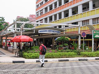
Hougang is a planning area and residential town located in the North-East Region of Singapore. The town is the second most populous in the region, being home to 222,310 residents. Hougang planning area is bordered by Sengkang to the north, Geylang and Serangoon to the south, Bedok to the southeast, Toa Payoh to the southwest, Paya Lebar to the east and Bishan and Ang Mo Kio to the west. It is a large planning area and is home to many residents in the northern region.
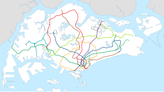
The Light Rail Transit (LRT), also known as the Light Rapid Transit, is a series of localised automated guideway transit systems acting as feeder services to the heavy rail Mass Rapid Transit, which together with the LRT forms the core of Singapore's rail transport services. The first LRT line was opened in 1999 and the system has since expanded to three lines, each serving a public housing estate, namely Bukit Panjang LRT Line, Sengkang LRT Line and Punggol LRT Line. Trains on these lines have at least one station linking it to the MRT and in turn the remainder of the LRT network.
The Ang Mo Kio Police Division is one of the seven land divisions of the Singapore Police Force. It was first established in 1965. It was previously located in Paya Lebar. In 1987, the division HQ migrated to its present location to better serve the public and meet its operational needs.
Ang Mo Kio Division serves a residential population of over 1.1 million residents. Ang Mo Kio Division’s area of coverage includes mature housing estates such as Ang Mo Kio, Hougang and Serangoon. It also oversees young but rapidly-developing residential estates like Sengkang and Punggol.
Punggol Temporary Bus Interchange is a temporary bus interchange in Punggol New Town, located adjacent to the Punggol MRT/LRT Station. It was built to allow for easy dismantling when the site is redeveloped as part of a major commercial development when Punggol New Town is more developed. The bus interchange was officially opened on November 30, 2003.

Fernvale is a neighbourhood of Sengkang New Town in Singapore. It is located between Sungei Punggol and the proposed Sengkang West Industrial Estate. The house numbers of the public apartment blocks in Fernvale begin with the number '4' (4xx). Fernvale is the newest neighbourhood in Sengkang Town to be completed by the Housing and Development Board (HDB). Seletar Mall, a new shopping amenity which houses Sengkang's first cineplex, is located within this neighbourhood. In 2017, A proposed community facility to be located next to Seletar Mall was announced, which houses a community club, childcare centre, hawker centre and wet market. The community facility is slated to be ready by the second half of 2020.

Ang Mo Kio Group Representation Constituency is a six-member Group Representation Constituency (GRC) in the north eastern region of Singapore. The constituency encompasses the majority of Ang Mo Kio, Jalan Kayu, the northern half of Serangoon North, a small portion of the western half of Sengkang (Fernvale), a portion of northern Hougang, and a small portion of Yishun.

Fernvale LRT station (SW5) is an LRT station on the Sengkang LRT Line West Loop in Fernvale, Singapore. It was opened in January 2005 together with the Punggol LRT East Loop. Like Dover MRT station on the East West Line, this station is one of few above ground stations that has two opposing side platforms. This station has a similar design to Sam Kee LRT Station as it is not built on a road median. A major mall beside the station, The Seletar Mall, opened its doors to the public on 28 November 2014.
Kadaloor LRT station (PE5) is an LRT station on the Punggol LRT Line East Loop in Singapore. It was opened in January 2005 together with the Sengkang LRT West Loop. Kadaloor was named after Cuddalore, an ancient town in the Indian state of Tamil Nadu.
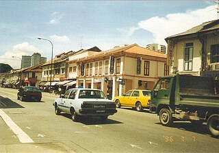
Serangoon Road is a major road in Singapore, running from Little India to Kallang. It is a one-way road, with Jalan Besar and Bendemeer Road running parallel to Serangoon Road in the other direction.

Buangkok is a neighbourhood located in north eastern Singapore. Whilst its boundaries are vague, the neighbourhood is roughly spread across the Trafalgar and Compassvale subzones of the Hougang and Sengkang Planning Areas respectively, as designated by the URA.

Sungei Punggol is a river located within the North-East Region in Singapore.

Sungei Serangoon is a river in the north-eastern part of Singapore. The 8-kilometre river starts as a canal near Tampines Road, and flows through Hougang, where it is joined by tributary Sungei Pinang just before Sengkang, before flowing towards Lorong Halus, where it is joined by another tributary Sungei Blukar, before emptying into the Serangoon Harbour. The river is also known as the Serangoon Estuary. Since 2011, the river has been converted into a reservoir - Serangoon Reservoir.
Upper Serangoon Viaduct, is a viaduct in Serangoon that was built on top of Upper Serangoon Road. Opened in 2002, the viaduct was built to allow residents living in the north-eastern part of Singapore, especially residents living in Hougang, Buangkok, Sengkang and Punggol, a high-speed access to the city centre. The viaduct starts south of the junction of Upper Serangoon Road, Bartley Road and Braddell Road and ends at the north of the junction of Upper Serangoon Road and Yio Chu Kang Road.

Kovan is a neighbourhood located within the town of Hougang, in the North-East Region of Singapore. Kovan was traditionally an area associated with the Teochew community. A number of road names at Kovan commemorate the more prominent members of this community. Kovan's Teochew name is "La gou jio", which means six miles from the Fullerton Hotel. The neighbourhood today, largely consists of private housing properties, where a majority of the residents live in terrace homes, semi-detached and bungalows.

The North East Community Development Council is one of five Community Development Councils (CDCs) set up across the Republic of Singapore to aid in local administration of governmental policies and schemes. They are funded in part by the government although they are free to engage in fund-raising activities.
Punggol Single Member Constituency was a former single member constituency in the undeveloped Punggol, from 1959 to 1991.
Yio Chu Kang Road is a major two-way road in Singapore that links Serangoon to Ang Mo Kio. At 9.4 km long, it is the longest non-expressway road in the country. En route, it passes through the junctions with Hougang Avenue 2, Ang Mo Kio Avenue 3, Ang Mo Kio Avenue 5, Buangkok Green, Sengkang West Road, Central Expressway and Lentor Avenue before concluding at Upper Thomson Road.


