
Geylang is a planning area and township located on the eastern fringe of the Central Region of Singapore, bordering Hougang and Toa Payoh in the north, Marine Parade in the south, Bedok in the east, and Kallang in the west.

The East Coast Parkway is an expressway that runs along the southeastern coast of Singapore. The expressway is approximately 20 kilometres (12 mi) in length, and connects Singapore Changi Airport in the east to the Benjamin Sheares Bridge in the south of the main island, and to the Marina Coastal Expressway. It has an interchange with the Pan Island Expressway at the Changi Flyover, about 1 kilometre (0.62 mi) from the eastern end of the expressway.

Tampines is a planning area and residential town in the East Region of Singapore. The planning area is bordered by Bedok and Paya Lebar to the west, Pasir Ris to the north, Changi to the east and the Singapore Straits to the south. Tampines New Town is located in the northern portion of Tampines planning area. Tampines is the third largest new town in Singapore by area, covering over 2089 hectares of land and also is the third most populated new town, following Bedok and Jurong West. It is the regional centre for the East Region.
Kembangan is a subzone and residential precinct located in the town of Bedok in the East Region of Singapore. It consists largely of private residential areas and a small public housing estate along Lengkong Tiga.

Bedok is a planning area and matured residential town located in the East Region of Singapore. Population wise, Bedok is the largest planning area in the Republic, being home to an estimated 289,000 residents. This high demographic is largely explained by the affordable public housing in Bedok New Town, due to its relatively distant location from the Central Area. Besides public housing developments, private residences are also prevalent in the area, most of which are found in the neighbourhoods of Bayshore, Frankel Avenue and Siglap, in western and southwestern Bedok. Apart from the maritime boundary that the area shares with the Singapore Strait to the south and southeast, Bedok is also bounded by five other planning areas: Paya Lebar to the north, Hougang to the northwest, Tampines to the northeast and east, Geylang to the west and Marine Parade to the southwest.
The Pan Island Expressway is the oldest and longest of Singapore's expressways. Currently, it is also Singapore's longest road. It extends along the length of the island, connecting Tuas in the west to Singapore Changi Airport in the east. Its length is 42.8 kilometres (26.6 mi).

Siglap is a neighbourhood located in Bedok in the East Region of Singapore. The area also encompasses the Frankel and Opera Estates and their names have sometimes been used interchangeably to refer to the approximate same area. The planning subzone area of Siglap as defined by the Urban Redevelopment Authority (URA) is confusingly and inaccurately referred to as the small strip of land between Victoria Junior College and Bedok South Avenue 1. It is a residential area where a majority live in landed homes such as freehold semi-detached houses and bungalows. Some of the land parcels near Siglap Centre have been redeveloped into serviced apartments and condominiums. The few Housing and Development Board flats in Siglap have been demolished in 2015 under the Selective En bloc Redevelopment Scheme. The East Coast Park is also located nearby, across the East Coast Parkway.
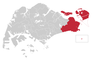
East Coast Group Representation Constituency is a four-member Group Representation Constituency in the eastern area of Singapore. The areas of the Group Representation Constituency consists of East Coast, Bedok, Changi-Simei, Siglap, Tampines, Pasir Ris, Kampong Chai Chee, Changi Airport and the offshore islands of Pulau Tekong, Pulau Ubin and Pedra Branca. The GRC also covers a large portion of Singapore's eastern territorial waters.
Tanah Merah, is a geographical region located along the south-eastern coast of the East Region of Singapore. Although its boundaries aren't exactly clear, it is often widely accepted that term "Tanah Merah", is used to refer to the southern coast of present-day Bedok, Tampines, Changi and Changi Bay.

Chai Chee, also known as Kampong Chai Chee, is a housing estate located in the town of Bedok in Singapore. The estate was named after a village known as Kampong Chai Chee which formerly occupied the vicinity. It is served by two major namesake roads, namely Chai Chee Street and Chai Chee Drive, with minor lanes of Chai Chee Road, Chai Chee Avenue and the original Jalan Chai Chee. Part of the estate today sits atop a hill that overlooks neighbouring Kembangan and Opera Estate.
Bartley Road is a major road in Singapore extending from Upper Serangoon Road to Tampines Avenue 10. The road has a distance of 5.8 km. En route, it passes through the areas of Serangoon, Bartley, Paya Lebar, Defu, Kaki Bukit and Bedok Reservoir. Bus services 28, 93 and 158 ply along the original Bartley Road from Upper Serangoon Road to Upper Paya Lebar Road.

Bedok Town Park is a community park located at Bedok North Ave 3 in Singapore. It is bounded by Bedok North Road, Bedok North Avenue 3 and the Pan Island Expressway.

The South East Community Development Council is one of five Community Development Councils (CDCs) set up across the Republic of Singapore to aid in local administration of governmental policies and schemes. They are funded in part by the government although they are free to engage in fund-raising activities.

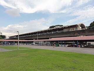
Bedok North MRT station (DT29) is an underground Mass Rapid Transit station on the Downtown Line in the northern part of Bedok, Singapore, located along Bedok North Road, near the Pan-Island Expressway flyover.

Kaki Bukit is an industrial area located in Bedok in the East Region of Singapore. It is home to many high tech industrial companies and warehouses. There used to be a prison complex called Kaki Bukit Centre, which was converted to a prison school in 2000, however it has since moved to Tanah Merah and the Acacia Welfare Home now stands in its place. On the south of Kaki Bukit is Jalan Tenaga and Jalan Damai neighbourhoods of Bedok Reservoir Road. Redevelopments are in the pipeline for Kaki Bukit beyond 2030 when Paya Lebar Airbase located just north of the estate relocates to Changi. Not only would land be freed up for use but building height restrictions, that are currently in place for safety reasons because the estate is directly aligned with the airbase runway, would also be lifted. Kaki Bukit is classified by Urban Redevelopment Authority (URA) as a subzone under the planning area of Bedok, its boundaries differ from the constituency boundaries used by the Singapore Parliament.
Tampines Single Member Constituency is a former single member constituency in Tampines, Singapore and is one of the oldest wards. It existed from 1959 to 1988.
Punggol-Tampines Single Member Constituency is a former short-lived single member constituency in Tampines and Punggol, Singapore that existed only from 1955 to 1959.
New Upper Changi Road is a major two-way road in Bedok, Singapore, serving as the boundary of Bedok North and Bedok South. The road begins in the west at its traffic junction with Sims Avenue East and Changi Road, and ends in the east at the junction of Simei Avenue and Xilin Avenue. The road continues in the northeastern direction as Upper Changi Road East.

