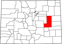
Punkin Center, Colorado | |
---|---|
Nickname: Pumpkin Center | |
Coordinates: 38°51′07″N103°42′02″W / 38.85194°N 103.70056°W Coordinates: 38°51′07″N103°42′02″W / 38.85194°N 103.70056°W | |
Country | United States |
State | Colorado |
Counties | Lincoln [1] |
Elevation | 5,364 ft (1,635 m) |
Time zone | UTC-7 (MST) |
• Summer (DST) | UTC-6 (MDT) |
ZIP codes | |
Area code | 719 |
Punkin Center is a small, rural unincorporated community in Lincoln County, Colorado, United States, located at the junction of State Highway 94 and State Highway 71. [3] [4]
John Stevens built the first store at the farmers crossroads in 1920. He painted each new building a pumpkin color, inspiring the name. Everything burned in the 1950s. [1] Its mostly white population was 4 according to a Denver Post article. [5] There is a communication tower near the intersection of the highways, and a larger communication tower about 3 miles (4.8 km) southwest of the intersection. The Post Offices at Hugo (ZIP Code 80821) and Ordway (ZIP 81063) serve Punkin Center postal addresses. [2]
A ZIP Code is a postal code used by the United States Postal Service (USPS). Introduced on July 1, 1963, the basic format consisted of five digits. In 1983, an extended ZIP+4 code was introduced; it included the five digits of the ZIP Code, followed by a hyphen and four digits that designated a more specific location.
Edwards is an unincorporated town, a post office, and a census-designated place (CDP) located in and governed by Eagle County, Colorado, United States. Edwards is the principal town of the Edwards, CO Micropolitan Statistical Area. The Edwards post office has the ZIP Code 81632. At the United States Census 2010, the population of the Edwards CDP was 10,266, while the population of the 81632 ZIP Code Tabulation Area was 10,267. The Edwards Metropolitan District provides services.
Kittredge is an unincorporated town, a post office, and a census-designated place (CDP) located in and governed by Jefferson County, Colorado, United States. The CDP is a part of the Denver–Aurora–Lakewood, CO Metropolitan Statistical Area. The Kittredge post office has the ZIP code 80457. At the United States Census 2010, the population of the Kittredge CDP was 1,304, while the population of the 80457 ZIP Code Tabulation Area was 612.
Atwood is an unincorporated town, a post office, and a census-designated place (CDP) located in and governed by Logan County, Colorado, United States. The CDP is a part of the Sterling, CO Micropolitan Statistical Area. The Atwood post office has the ZIP Code 80722. At the United States Census 2010, the population of the Atwood CDP was 133, while the population of the 80722 ZIP Code Tabulation Area was 349 including adjacent areas.
Wray is the home rule municipality that is the county seat of Yuma County, Colorado, United States. Located in the Colorado Plains, the city is 170 miles east of Denver, 9 miles west of the Nebraska state line, and 25 miles northwest of the Kansas state line. The population was 2,358 at the 2020 United States census.
Woody Creek is an unincorporated town, a post office, and a census-designated place (CDP) located in and governed by Pitkin County, Colorado, United States. The Woody Creek post office has the ZIP Code 81656. At the United States Census 2010, the population of the Woody Creek CDP was 263, while the population of the 81656 ZIP Code Tabulation Area was 242. The Woody Creek Metropolitan District provides services. The CDP is a part of the Glenwood Springs, CO Micropolitan Statistical Area.
Rollinsville is a census-designated place (CDP) and post office in and governed by Gilpin County, Colorado, United States. The CDP is a part of the Denver–Aurora–Lakewood, CO Metropolitan Statistical Area. The Rollinsville post office has the ZIP Code 80474. At the United States Census 2010, the population of the Rollinsville CDP was 181.
Divide is an unincorporated town, a post office, and a census-designated place (CDP) located in and governed by Teller County, Colorado, United States. The CDP is a part of the Colorado Springs, CO Metropolitan Statistical Area. The Divide post office has the ZIP Code 80814. At the United States Census 2010, the population of the Divide CDP was 127, while the population of the 80814 ZIP Code Tabulation Area was 4,023 including adjacent areas.
Elbert is an unincorporated town, a post office, and a census-designated place (CDP) located in and governed by Elbert County, Colorado, United States. The CDP is a part of the Denver–Aurora–Lakewood, CO Metropolitan Statistical Area. The Elbert post office has the ZIP Code 80106. At the United States Census 2010, the population of the Elbert CDP was 230, while the population of the 80106 ZIP Code Tabulation Area was 4,232 including adjacent areas.
Twin Lakes is a pair of glacier-carved alpine lakes about 15 miles (24 km) south of historic Leadville, Colorado. They are downstream along the Arkansas River, whose headwaters are by Leadville. The lakes, however, are on a tributary, Lake Creek, which joins the Arkansas just below the lakes. After dredging, the lakes now have a surface area of 2,700 acres (11 km2), and they serve as a reservoir to store water for use in the Front Range. Both east and west lakes are recreation areas for boating and fishing.
Hasty is an unincorporated town, a post office, and a census-designated place (CDP) located in and governed by Bent County, Colorado, United States. The Hasty post office has the ZIP code 81044. At the United States Census 2010, the population of the Hasty CDP was 144, while the population of the 81044 ZIP Code Tabulation Area was 224 including adjacent areas.
Idledale is an unincorporated town, a post office, and a census-designated place (CDP) located in and governed by Jefferson County, Colorado, United States. The CDP is a part of the Denver–Aurora–Lakewood, CO Metropolitan Statistical Area. The Idledale post office has the ZIP code 80453. At the United States Census 2020, the population of the Idledale CDP was 214.
Maybell is a census-designated place (CDP) and post office in and governed by Moffat County, Colorado, United States. The CDP is a part of the Craig, CO Micropolitan Statistical Area.
McCoy is an unincorporated town, a census-designated place (CDP), and a post office located in and governed by Eagle County, Colorado, United States. The CDP is a part of the Edwards, CO Micropolitan Statistical Area. The McCoy post office has the ZIP Code 80463. At the United States Census 2010, the population of the McCoy CDP was 24, while the population of the 80463 ZIP Code Tabulation Area was 136 including adjacent areas.
Weldona is an unincorporated town, a post office, and a census-designated place (CDP) located in and governed by Morgan County, Colorado, United States. The CDP is a part of the Fort Morgan, CO Micropolitan Statistical Area. The Weldona post office has the ZIP Code 80653. At the United States Census 2010, the population of the Weldona CDP was 139, while the population of the 791 ZIP Code Tabulation Area was 4,232 including adjacent areas.
Weston is an unincorporated town, a post office, and a census-designated place (CDP) located in and governed by Las Animas County, Colorado, United States. The Weston post office has the ZIP Code 81091. At the United States Census 2010, the population of the Weston CDP was 55, while the population of the 81091 ZIP Code Tabulation Area was 812 including adjacent areas.
Wolcott is an unincorporated town, a post office, and a census-designated place (CDP) located in and governed by Eagle County, Colorado, United States. The CDP is a part of the Edwards, CO Micropolitan Statistical Area. The Wolcott post office has the ZIP Code 81655. At the United States Census 2010, the population of the Wolcott CDP was 15, while the population of the 81655 ZIP Code Tabulation Area was 65 including adjacent areas.
Bovina is an unincorporated community in Lincoln County, Colorado, United States. The ZIP Code of Bovina (80818) is held at the Genoa Post Office.
Hall Station is a small rural locale in Lincoln County, Colorado, United States on the northeast corner of the intersection of State Highway 94 and County Road 11. Hall Station is a 101 by 211 ft grass/dirt area, suitable for parking, and fenced on three sides. Despite the name, the nearest railroad is 39 miles (62 km) east and 52 miles (84 km) west. Hall Station is located on Highway 94 two miles (3 km) south of the Elbert County line between the Highway 94 bridge crossings of Little Horse Creek and Horse Creek. The nearest U.S. Post Office is in Rush.
Taft is an unincorporated community in Lincoln County, Tennessee, United States. The community has a post office with ZIP code 38488. Taft is located at the intersection of State Route 110 and State Route 274.
Media related to Punkin Center, Colorado at Wikimedia Commons