Boyero, Colorado

Last updated
Boyero, Colorado
Usa edcp location map.svg
Red pog.svg
Boyero
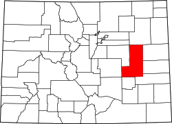
Location of Boyero, Colorado.
USA Colorado location map.svg
Red pog.svg
Boyero
Boyero (Colorado)
Coordinates: 38°56′34″N103°16′45″W / 38.9428°N 103.2791°W / 38.9428; -103.2791 (Boyero, Colorado) [1]
Country United States of America
State State of Colorado
County Lincoln County [2]
Government
  Type unincorporated community
  Body Lincoln County [2]
Elevation
[1]
4,721 ft (1,439 m)
Time zone UTC−07:00 (MST)
  Summer (DST) UTC−06:00 (MDT)
ZIP Code
80821 (Hugo) [3]
Area code 719
GNIS pop ID 195163

Boyero is an unincorporated community in Lincoln County, Colorado, United States. [1]

Contents

History

The Boyero, Colorado, post office operated from March 3, 1902, until July July 20, 1973, when it was converted to a contract post office of the Hugo, Colorado, post office (Zip code 80821). [4]

The community was named for the local cattle industry. "Boyero" means "drover" in the Spanish language. [5]

Geography

Boyero is located at coordinates 38°56′34″N103°16′45″W / 38.9428°N 103.2791°W / 38.9428; -103.2791 (Boyero, Colorado) at an elevation of 4,721 feet (1,439 m). [1]

See also

Related Research Articles

<span class="mw-page-title-main">Arboles, Colorado</span> Census Designated Place in State of Colorado, United States of America

Arboles is an unincorporated community and a census-designated place (CDP) on the Southern Ute Indian Reservation in southwestern Archuleta County, Colorado, United States. At the United States Census 2020, the population of the Arboles CDP was 308. The town's name means "trees" in Spanish. The Arboles post office has the ZIP code 81121.

<span class="mw-page-title-main">Olney Springs, Colorado</span> Town in Crowley County, Colorado, United States

Olney Springs is a statutory town in Crowley County, Colorado, United States. The population was 315 at the 2020 census.

<span class="mw-page-title-main">Ordway, Colorado</span> Town in and county seat of Crowley County, Colorado, United States

Ordway is a statutory town in and the county seat of Crowley County, Colorado, United States, that is also the most populous community in the county. The population was 1,066 at the 2020 census.

<span class="mw-page-title-main">Sugar City, Colorado</span> Town in Colorado, United States

Sugar City is a statutory town in Crowley County, Colorado, United States. The population was 259 at the 2020 census.

<span class="mw-page-title-main">Arriba, Colorado</span> Town in Lincoln County, Colorado, United States

Arriba is a Statutory Town located in Lincoln County, Colorado, United States. The town population was 202 at the 2020 United States census.

<span class="mw-page-title-main">Atwood, Colorado</span> Census Designated Place in State of Colorado, United States of America

Atwood is an unincorporated town, a post office, and a census-designated place (CDP) located in Logan County, Colorado, United States. The CDP is a part of the Sterling, CO Micropolitan Statistical Area. At the United States Census 2020, the population of the Atwood CDP was 138.

<span class="mw-page-title-main">Avondale, Colorado</span> Census-designated place in Pueblo County, Colorado, United States

Avondale is a census-designated place (CDP) and post office located in Pueblo County, Colorado, United States. The CDP is a part of the Pueblo, CO Metropolitan Statistical Area. The Avondale post office has the ZIP Code 81022. At the United States Census 2020, the population of the Avondale CDP was 594, while the population of the 81022 ZIP Code Tabulation Area was 1,624 including adjacent areas.

<span class="mw-page-title-main">Beulah Valley, Colorado</span> A Census Designated Place in Pueblo County, Colorado, United States

Beulah Valley is a census-designated place (CDP) in Pueblo County, Colorado, United States. The CDP is a part of the Pueblo, CO Metropolitan Statistical Area. The population of the Beulah Valley CDP was 518 at the United States Census 2020. The Beulah post office (Zip Code 81023) serves the area.

<span class="mw-page-title-main">Amherst, Colorado</span> Census-designated place in Phillips County, Colorado, United States

Amherst is a census-designated place (CDP) and a post office located in Phillips County, Colorado, United States. As of the United States Census 2020, the population of the Amherst CDP was 47.

<span class="mw-page-title-main">Anton, Colorado</span> An unincorporated community in Washington County, Colorado, United States

Anton is an unincorporated community and U.S. Post Office in Washington County, Colorado, United States.

Austin is a neighborhood within the boundaries of the incorporated Town of Orchard City in Delta County, Colorado, United States. There is a U.S. Post Office in Austin with the ZIP Code 81410.

<span class="mw-page-title-main">Bristol, Colorado</span> Unincorporated community in Prowers County, Colorado, United States

Bristol is an unincorporated community in Prowers County, Colorado, United States.

<span class="mw-page-title-main">Karval, Colorado</span> Unincorporated community in Lincoln County, Colorado, United States

Karval is an unincorporated community in Lincoln County, Colorado, United States.

<span class="mw-page-title-main">Vernon, Colorado</span> Unincorporated community in Colorado, United States

Vernon is an unincorporated town and census-designated place (CDP) in Yuma County, Colorado, United States. At the United States Census 2020, the population of the total Vernon CDP was 38.

<span class="mw-page-title-main">Wetmore, Colorado</span> Unincorporated community in Custer County, Colorado, United States

Wetmore is an unincorporated community and a U.S. Post Office located in Custer County, Colorado, United States.

<span class="mw-page-title-main">Wild Horse, Colorado</span> Unincorporated community in Colorado, United States

Wild Horse is an unincorporated community in Cheyenne County, Colorado, United States.

Woodrow is an unincorporated rural hamlet consisting of a U.S. Post Office, a church and 3 houses, located in Washington County, Colorado, United States. The Woodrow Post Office serves ZIP Code 80757.

<span class="mw-page-title-main">Timpas, Colorado</span> Unincorporated community in Colorado, United States

Timpas is an unincorporated community located in Otero County, Colorado, United States. The U.S. Post Office at La Junta now serves Timpas postal addresses.

Bovina is an unincorporated community in Lincoln County, Colorado, United States.

Antlers is an unincorporated community in Garfield County, Colorado, United States.

References

  1. 1 2 3 4 "Boyero, Colorado". Geographic Names Information System . United States Geological Survey, United States Department of the Interior . Retrieved January 30, 2025.
  2. 1 2 "Colorado Counties". Colorado Department of Local Affairs . Retrieved January 30, 2025.
  3. "ZIP Code Lookup". United States Postal Service. January 3, 2007. Archived from the original (JavaScript/HTML) on September 3, 2007. Retrieved January 3, 2007.
  4. Bauer, William H.; Ozment, James L.; Willard, John H. (1990). Colorado Post Offices 1859–1989. Golden, Colorado: Colorado Railroad Historical Foundation. ISBN   0-918654-42-4.
  5. Dawson, John Frank (1954). Place names in Colorado: why 700 communities were so named, 150 of Spanish or Indian origin. Denver, CO: The J. Frank Dawson Publishing Co. p. 10.