
The River Severn, at 220 miles (354 km) long, is the longest river in Great Britain. It is also the river with the most voluminous flow of water by far in all of England and Wales, with an average flow rate of 107 m3/s (3,800 cu ft/s) at Apperley, Gloucestershire. It rises in the Cambrian Mountains in mid Wales, at an altitude of 2,001 feet (610 m), on the Plynlimon massif, which lies close to the Ceredigion/Powys border near Llanidloes. The river then flows through Shropshire, Worcestershire and Gloucestershire. The county towns of Shrewsbury and Gloucester and the City of Worcester lie on its course.

Deerhurst is a village and civil parish in Gloucestershire, England, about 2 miles (3 km) southwest of Tewkesbury. The village is on the east bank of the River Severn. The parish includes the village of Apperley and the hamlet of Deerhurst Walton. The 2011 Census recorded the parish's population as 906, the majority of whom live in Apperley.
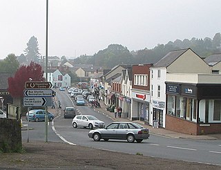
Lydney is a town and civil parish in Gloucestershire, England. It is on the west bank of the River Severn in the Forest of Dean District, and is 16 miles (25 km) southwest of Gloucester. The town has been bypassed by the A48 road since 1995. The population was about 8,960 in the 2001 census, reducing to 8,766 at the 2011 census. Increasing to 10,043 at the 2021 Census.

The Severn Railway Bridge was a bridge carrying the railway across the River Severn between Sharpness and Lydney in Gloucestershire, England. It was built in the 1870s by the Severn Bridge Railway Company, primarily to carry coal from the Forest of Dean to the docks at Sharpness; it was the furthest-downstream bridge over the Severn until the opening of the Severn road bridge in 1966. When the company got into financial difficulties in 1893, it was taken over jointly by the Great Western Railway and the Midland Railway companies. The bridge continued to be used for freight and passenger services until 1960, and saw temporary extra traffic on the occasions that the Severn Tunnel was closed for engineering work.

The River Frome, once also known as the Stroudwater, is a small river in Gloucestershire, England. It is to be distinguished from another River Frome in Gloucestershire, the Bristol Frome, and the nearby River Frome, Herefordshire. The river is approximately 25 miles (40 km) long.

Apperley is a village in Gloucestershire, England, about 3 miles (5 km) southwest of Tewkesbury, 1 mile (1.6 km) south of Deerhurst and 1⁄3 mile (0.5 km) east of the River Severn. It is the largest settlement in Deerhurst civil parish. In 2020 it had an estimated population of 625.

English Bicknor is a village and civil parish in the Forest of Dean district of west Gloucestershire, England. The 2011 Census recorded the population as 408. The village is near the county boundary with Herefordshire, opposite which is the village of Welsh Bicknor. The two villages are on opposite sides of the River Wye.

Stanton is a village and civil parish in Tewkesbury Borough, Gloucestershire, England. The village is a spring line settlement at the foot of the Cotswold escarpment, about 2+1⁄2 miles (4 km) southwest of Broadway in neighbouring Worcestershire. Broadway is Stanton's postal town. The 2011 Census recorded the parish's population as 198.

Frampton Mansell is a small English village 5 miles east-south-east of Stroud, Gloucestershire, in the parish of Sapperton. It lies off the A419 road between Stroud and Cirencester. It has a prominent mid-19th century, Grade II listed church with a set of five original stained-glass windows.

The Lydney Canal is a one-mile canal in Gloucestershire that runs inland from the River Severn to Lydney. It was opened in 1813 to trans-ship iron and coal from the Forest of Dean. It was once connected by a horse-drawn tramroad to Pidcock's Canal which brought materials down to the wharves by tub-boat.

Miserden is a village and civil parish in Stroud District, Gloucestershire, England, 4 miles north east of Stroud. The parish includes Whiteway Colony and the hamlets of Sudgrove and The Camp. In the 2001 census the parish had a population of 420, increasing to 449 at the 2011 census.

Purton is a village on the east bank of the River Severn, 3 miles north of Berkeley, in Gloucestershire, England. The village is in the civil parish of Hinton. It lies opposite the hamlet of Purton on the west bank of the river.

Forthampton is a village in Gloucestershire, England The village is located three miles from the market town of Tewkesbury and features "a great number of interesting buildings", fine views, several duck ponds, a church, a collection of thatched cottages and farmsteads, a village hall and a village club. Forthampton was designated a Conservation Area in 2003 due to its special architectural and historic interest, character and appearance which it was desirable to preserve and enhance. Notable features of the village include extensive historic buildings clustered around farm houses situated at the centre of the village, the many roadside ponds and grass verges around and between buildings and significant panoramic views.

Bledisloe was an ancient hundred of Gloucestershire, England. It comprised the ancient parishes of
Sidney Gambier-Parry was a British architect.
Albert Estcourt was a builder in Gloucestershire, England, in the 19th century who with his brother, and later on his own, constructed a number of notable buildings in the county and across southern England.
Taynton is a village and civil parish in the Forest of Dean district of Gloucestershire, England. It lies about 2.5 miles (4.0 km) south-east of Newent, about 2 miles (3.2 km) north-east of Mitcheldean and 7 miles (11 km) west of Gloucester. The parish covers 1,029 hectares (3.97 sq mi) At the time of the 2011 Census, the population of the parish was 438.

Lechlade Manor in Lechlade, Gloucestershire, England, is a Victorian country house built for George Milward, a lawyer, by John Loughborough Pearson. Primarily an ecclesiastical architect, working on over 200 church buildings in his fifty-year career, the manor represents one of Pearson's rare forays into secular building. Dating from 1872 to 1873, Lechlade was subsequently sold to the Sisters of St Clotilde and operated as a convent for much of the 20th century. In the 1990s, it was converted back to a private residence, with some enabling development in the grounds. Lechlade Manor is a Grade II listed building.

The Church of St Mary and St Peter, Tidenham, is a parish church of the Diocese of Gloucester, England. It dates from the 13th and 14th centuries, and was extensively restored by John Norton in 1858. It is a Grade II* listed building and remains an active parish church.
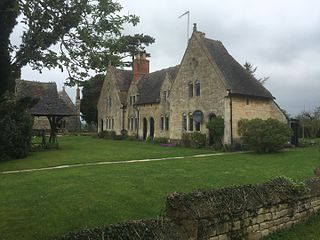
The Yorke Almshouses, Nos. 14–17 Church Row, Forthampton, Gloucestershire, England, are a range of four almshouses designed by the architect William Burges in 1865. The block is a Grade II listed building and the almshouses remain private residences.

