Queens is a borough of New York City, coextensive with Queens County, in the U.S. state of New York. It is the largest borough of New York City in area and is adjacent to the borough of Brooklyn at the western end of Long Island, with Nassau County to the east. Queens also shares water borders with the boroughs of Manhattan, the Bronx, and Staten Island.
Sunnyside and Sunny Side may refer to:

Emmons is an unincorporated community located on the Big Coal River in Boone and Kanawha counties in the U.S. state of West Virginia. Jay Rockefeller's political affiliation with West Virginia began in 1964-1965 while he served as a VISTA volunteer in Emmons.
Quick is a small unincorporated community in Kanawha County, West Virginia, United States. It is located along Indian Creek Road. The community is where Whitoak Fork and Blue Creek come together and meet. It is also where the abandoned railroad that follows Blue Creek joins the road, and follows it all the way to the community of Hitop, along Pond Fork. Its post office is closed.
Belva is an unincorporated community and census-designated place in west Nicholas County and north Fayette County, West Virginia, United States; while the CDP only includes the Nicholas County portion, the Fayette County portion is considered part of the community. The town is situated at the bottomland surrounding the convergence of Bells Creek with Twentymile Creek and, subsequently, Twenty Mile Creek with the Gauley River. Belva is also the location of the convergence of two state highways: West Virginia Route 16 and West Virginia Route 39.

Kiahsville is an unincorporated community in southern Wayne County, West Virginia, United States. It is a part of the Huntington-Ashland, WV-KY-OH, Metropolitan Statistical Area (MSA). As of the 2000 census, the MSA had a population of 288,649. Its sister town is nearby Cove Gap.
Dickinson, also known as Quincy, is an unincorporated community in Kanawha County, West Virginia, United States. Dickinson is located on the north bank of the Kanawha River, 3 miles (4.8 km) southeast of Belle. The community is served by U.S. Route 60.
Corton is an unincorporated community in Kanawha County, West Virginia, United States. Corton is located on the Elk River and West Virginia Route 4, 4 miles (6.4 km) east of Clendenin.
Sanger is an unincorporated community in Fayette County, West Virginia, United States.
Wriston is an unincorporated community in Fayette County, West Virginia, United States.
Olcott is an unincorporated community and coal town in Kanawha County, West Virginia, United States. Its post office is closed.
Boone was an unincorporated community in Fayette County, West Virginia, United States.
Weir is an unincorporated community in Kanawha County, West Virginia, United States. Its post office is called Falling Rock.
Legg is an unincorporated community in Kanawha County, West Virginia, United States. Its post office is closed.
Rensford is an unincorporated community in Kanawha County, West Virginia, United States. Its post office is closed. It was also known as Point Lick.
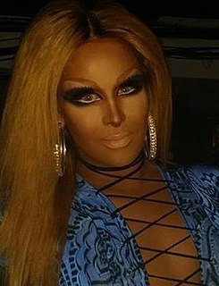
Michael Feliciano, known by his stage name Roxxxy Andrews, is an American drag performer who came to international attention on the fifth season of RuPaul's Drag Race and the second season of RuPaul's Drag Race All Stars.
Jenky is an unincorporated community in Fayette County, West Virginia, United States.
Grayden is an unincorporated community in Fayette County, West Virginia, United States. It was also known as Free Union.

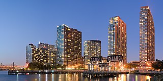
Queens West is a district and redevelopment project along the East River in Long Island City, Queens, New York City. The project, located on Hunter's Point south of the Anable Basin, is a joint project sponsored by the Port Authority of New York & New Jersey (PANYNJ) and the Empire State Development Corporation (ESD). The Queens West Development Corporation (QWDC), a subsidiary of ESD, was established in 1992 to facilitate implementation of the approved development plan.


