
Richmond is a city in the coastal Lower Mainland region of British Columbia, Canada. Mainly a suburban city, it occupies almost the entirety of Lulu Island, between the two estuarine distributaries of the Fraser River. Encompassing the adjacent Sea Island and several other smaller islands and uninhabited islets to its north and south, the suburb neighbours Vancouver and Burnaby on the Burrard Peninsula to the north, New Westminster and Annacis Island to the east, Delta to the south, and the Strait of Georgia to the west.

New Westminster is a city in the Lower Mainland region of British Columbia, Canada, and a member municipality of the Metro Vancouver Regional District. It was founded by Major-General Richard Moody as the capital of the Colony of British Columbia in 1858 and continued in that role until the Mainland and Island colonies were merged in 1866. It was the British Columbia Mainland's largest city from that year until it was passed in population by Vancouver during the first decade of the 20th century.
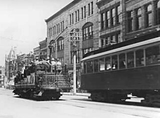
The British Columbia Electric Railway (BCER) was a historic railway which operated in southwestern British Columbia, Canada. Originally the parent company for, and later a division of, BC Electric Company, the BCER assumed control of existing streetcar and interurban lines in southwestern British Columbia in 1897, and operated the electric railway systems in the region until the last interurban service was discontinued in 1958. During and after the streetcar era, BC Electric also ran bus and trolleybus systems in Greater Vancouver and bus service in Greater Victoria; these systems subsequently became part of BC Transit, and the routes in Greater Vancouver eventually came under the control of TransLink. Trolley buses still run in the City of Vancouver with one line extending into Burnaby.

The Second Narrows Rail Bridge is a vertical-lift railway bridge that crosses the Burrard Inlet and connects Vancouver with the North Shore. The bridge's south end connects directly to the Thornton Tunnel, which connects it to the main Canadian rail network. As the name suggests, it is located at the second narrowing of the Burrard Inlet.
Highway 91A, or the Queensborough Connector, is a 3 km (2 mi) long spur off Highway 91. Highway 91A crosses the Queensborough Bridge and terminates at Marine Way, allowing traffic into New Westminster. Residents of New Westminster can use Highway 91A as a convenient route towards the Canada/U.S. border. Although the Queensborough Bridge has existed since 1960, the highway spur section was opened only in 1986, at the same time the first section of Highway 91 was completed.

The Island Corridor, previously the Esquimalt & Nanaimo Railway, is a railway operation on Vancouver Island. It is owned by the Island Corridor Foundation, a registered charity. The railway line is 225 kilometres (140 mi) in length from Victoria to Courtenay, known as the Victoria Subdivision, with a branch line from Parksville to Port Alberni, known as the Port Alberni Subdivision, of 64 kilometres (40 mi), for a total 289 kilometres (180 mi) of mainline track. In 2006, the Island Corridor Foundation acquired the railway's ownership from RailAmerica and Canadian Pacific Railway.

Queensborough Bridge is a highway bridge in New Westminster, British Columbia. It was built in 1960 by John Laing and Son (Canada) for the City of New Westminster and cost $4 million. The bridge spans the north arm of the Fraser River for road access from the main part of New Westminster to the suburb of Queensborough at the east end of Lulu Island, giving the bridge its name.

Scott Road is an elevated station on the Expo Line of Metro Vancouver's SkyTrain rapid transit system. The station is located near the south end of the Pattullo Bridge in the South Westminster neighbourhood of Surrey, British Columbia, Canada. It also serves the Bridgeview neighbourhood of Whalley, and the interchange between King George Boulevard and Scott Road is located to the north of the station. The station opened on March 16, 1990, and was renovated from 2013 to 2014.
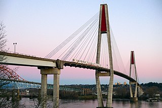
The SkyBridge is a cable-stayed railway bridge in Metro Vancouver, British Columbia, Canada. Built between 1987 and 1989, it carries trains of the Expo Line of TransLink's SkyTrain across the Fraser River between New Westminster and Surrey. The SkyBridge opened for revenue use on March 16, 1990, with the second half of the Phase II extension of SkyTrain to Scott Road station.
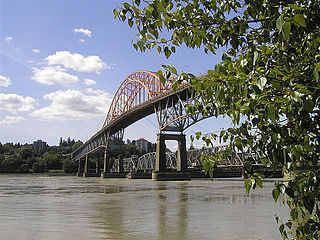
The Pattullo Bridge is a through arch bridge that crosses the Fraser River and links the cities of New Westminster and Surrey in Metro Vancouver, British Columbia. It was named in honour of Thomas Dufferin Pattullo, the 22nd Premier of British Columbia. A key link between Surrey and the rest of Greater Vancouver, the Pattullo Bridge handles an average of 75,700 cars and 3840 trucks daily, or roughly 20% of vehicle traffic across the Fraser River as of 2013. A replacement bridge began construction in 2021 and is scheduled to be completed in late 2025.

The New Westminster Bridge is a swing bridge that crosses the Fraser River and connects New Westminster with Surrey, British Columbia, Canada.

Lulu Island is the name of the largest island in the estuary of the Fraser River, located south of Vancouver, British Columbia, Canada, and the second-most populous island in British Columbia, after Vancouver Island. The city of Richmond occupies most of the island, while a small section at the eastern tip, known as Queensborough, is part of the city of New Westminster.
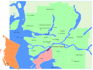
Annacis Island is a narrow island under the jurisdiction of City of Delta in Lower Mainland, British Columbia, located just downstream of the south arm of the Fraser River bifurcation between Lulu Island to the north and the Delta peninsula to the south. The island is now mostly an industrial zone, and contains one of Metro Vancouver's secondary wastewater treatment plants, the Annacis Island Wastewater Treatment Plant. The island is also home to the British Columbia Institute of Technology's Annacis Island campus.

The Annacis Island Swing Bridge, built in 1986, is a road and rail swing bridge over the Annacis Channel of the Fraser River in the Lower Mainland of British Columbia, Canada. The bridge connects the community of Queensborough, part of New Westminster on Lulu Island, to Annacis Island in Delta.

Queensborough is a neighbourhood in the city of New Westminster, British Columbia, Canada. It is on the eastern tip of Lulu Island on the Fraser River.

Opened in 1931, the Canadian National Railway (CNR) steel truss swing span railway bridge over the north arm of the Fraser River in Metro Vancouver links Burnaby with Richmond and the south arm Vancouver Fraser Port Authority facilities on Lulu Island.

The Marpole CP Rail Bridge was a partially dismantled crossing over the north arm of the Fraser River, and River Dr., in Metro Vancouver.
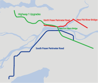
The Gateway Program is a C$3.0 billion regional transportation project for Metro Vancouver and surrounding areas that is being managed by the British Columbia Ministry of Transportation. The ministry introduced the Gateway Program on January 31, 2006, as a means to address growing congestion and reduce travel times. The bulk of the construction took place from 2006 to 2014 and saw the completion of the Pitt River Bridge, the Port Mann Bridge, improvements to Highway 1 and construction of the South Fraser Perimeter Road.
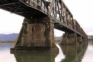
The Mission Railway Bridge is a Canadian Pacific Railway bridge spanning the Fraser River between Mission, and Abbotsford, British Columbia, Canada.
Marine Drive is the name for three major roadways in Greater Vancouver, British Columbia, Canada. The roads are known for running parallel to major bodies of water, with some sections being a major arterial road, while other serve local traffic. Marine Way is the name applied to a section of Marine Drive that was bypassed in the early 1980s.


